Geolocate

Suwon-si topographic map

Click on the map to display elevation.

Suwon-si

Since 2013, Suwon has been home to KT Wiz. The team played at Sungkyunkwan University till Suwon Baseball Stadium remodelling was completed in time for their elevation to the KBO League in 2015. The stadium was previously the home of the Hyundai Unicorns, but this team folded after the 2007 season.

Wikipedia (CC-BY-SA 3.0)

About this map

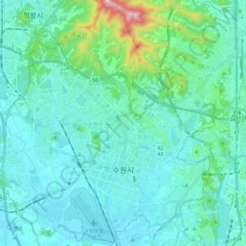
Name: Suwon-si topographic map, elevation, terrain.

Location: Suwon-si, Gyeonggi, South Korea (37.22453 126.92697 37.35105 127.08987)

Average elevation: 289 ft

Minimum elevation: 52 ft

Maximum elevation: 1,818 ft

Other topographic maps

Click on a map to view its topography, its elevation and its terrain.

Udu-ri

South Korea > Yeosu-si

Average elevation: 52 ft

Soseong-ri

South Korea > Seongju-gun > Chojeon-myeon

Average elevation: 1,086 ft

Bugyang-ri

South Korea > Hwaseong-si

Average elevation: 203 ft

Seattle Park

South Korea > Daejeon

Average elevation: 167 ft

Deogyang-gu

South Korea > Goyang-si

Average elevation: 75 ft

Daebeop-ri

South Korea > Goseong-gun

Average elevation: 591 ft

Austrailia Pavilion

South Korea > Gwacheon-si

Average elevation: 472 ft

평택상하수도사업소

South Korea

Average elevation: 210 ft

Obong-ri

South Korea > Naju-si

Average elevation: 279 ft

Yeongsong-ri

South Korea > Pocheon-si

Average elevation: 381 ft

Hongwon-ri

South Korea > Cheorwon-gun

Average elevation: 856 ft

Hoamsan Mountain

South Korea > Yeosu-si

Average elevation: 325 ft

Ssangji-ri

South Korea > Suncheon-si

Average elevation: 591 ft

Sin-gok-ri

South Korea > Miryang-si

Average elevation: 978 ft

Gapyeong

South Korea > Gapyeong-gun

Average elevation: 515 ft

Bugam-ri

South Korea > Boeun-gun

Average elevation: 1,342 ft

Punggye-ri

South Korea > Icheon-si

Average elevation: 243 ft

Muan-eup

South Korea > Muan-gun

Average elevation: 141 ft

Daehoesan-ri

South Korea > Pocheon-si

Average elevation: 705 ft

우도

South Korea > Ganghwa-gun > Incheon > Seodo-myeon

Average elevation: 3 ft

Udo-myeon

South Korea

Average elevation: 7 ft

Panmunjeom

South Korea > Paju-si

Average elevation: 89 ft

Sonyang-myeon

South Korea > Sonyang-myeon

Average elevation: 157 ft

1156

South Korea > Pyeongchang-gun

Average elevation: 3,330 ft

Bukhan River

South Korea > Chuncheon-si

Average elevation: 486 ft

Hwapo-ri

South Korea > Goseong-gun > Geojin-eup > Hwapo-ri

Average elevation: 49 ft

Mangyeong-eup

South Korea > Gimje-si > Mangyeong-eup

Average elevation: 30 ft

Gapa Island

South Korea > Seogwipo-si > Gapa-ri

Average elevation: 3 ft

Susong-dong

South Korea > Seoul > Susong-dong

Average elevation: 223 ft

Haui-myeon

South Korea > Sinan-gun > Haui-myeon

Average elevation: 30 ft

Seoraksan National Park

South Korea > Goseong-gun

Average elevation: 2,037 ft

Songgok-ri

South Korea > Hwaseong-si

Average elevation: 180 ft

Oji-ri

South Korea > Gokseong-gun > Ogok-myeon > Oji-ri

Average elevation: 358 ft

Sijeon-dong

South Korea > Yeosu-si > Sijeon-dong

Average elevation: 262 ft

Gye-dong

South Korea > Seoul

Average elevation: 249 ft

Inwangsan (Mt.)

South Korea > Seoul

Average elevation: 371 ft

Gear up for your next adventure:

🔌Solar Panel Charger - Charge gear sustainably outdoors
🧭Outdoor Navigation Book - Learn advanced navigation skills
🔥Fast-Boil Camping Stoves - Efficient cooking systems for quick trail meals
📚Navigation Handbooks - Master the art of reading topographic maps and using a compass
🦺Reflective Outdoor Gear - Safety gear for low‑light conditions

As an Amazon Associate, this site earns from qualifying purchases at no extra cost to you.