
Make a donation
Gear up for your next adventure:
As an Amazon Associate, this site earns from qualifying purchases at no extra cost to you.
Bidar topographic map
Click on the map to display elevation.
Make a donation
Gear up for your next adventure:
As an Amazon Associate, this site earns from qualifying purchases at no extra cost to you.
Bidar
Physiographically, the district can be divided into two regions, the northern low lands and southern high lands. The southern high lands are popularly known as Bidar plateau, which is made up of laterite. The ground altitudes are varying from 420 to 684 m (1,378 to 2,244 ft) above sea level. Bidar plateau has an elevation range from 640 to 684 m (2,100 to 2,244 ft) above sea level. The ground surface is flat, gently sloping forming broad valleys and flat topped hills. Flat topped hills with step-like sides exhibit the terraced landscape. The southern half of the district is a high plateau about 715 m (2,346 ft) above mean sea level and are well drained.
Make a donation
Gear up for your next adventure:
As an Amazon Associate, this site earns from qualifying purchases at no extra cost to you.
About this map
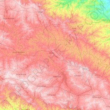
Name: Bidar topographic map, elevation, terrain.
Location: Bidar, Karnataka, India (17.58297 76.68988 18.47665 77.65591)
Average elevation: 1,890 ft
Minimum elevation: 1,181 ft
Maximum elevation: 2,254 ft
Make a donation
Gear up for your next adventure:
As an Amazon Associate, this site earns from qualifying purchases at no extra cost to you.
Other topographic maps
Click on a map to view its topography, its elevation and its terrain.
Hunsur
India > Karnataka > Hunasuru taluk
Hunsur is located at 12°19′N 76°17′E / 12.31°N 76.29°E / 12.31; 76.29. It is located at an elevation of 805 metres (2,641 ft) above mean sea level. The river Lakshmana Tirtha flows through the town and two bridges are built across the river. The town is the administrative center of Hunsur…
Average elevation: 2,598 ft
Make a donation
Gear up for your next adventure:
As an Amazon Associate, this site earns from qualifying purchases at no extra cost to you.
Make a donation
Gear up for your next adventure:
As an Amazon Associate, this site earns from qualifying purchases at no extra cost to you.
Dakshina Kannada
The topography of the district is plain up to 30 km (18.64 mi) inside the coast and changes to undulating hilly terrain sharply towards the east in the Western Ghats. Teak, bamboo and rosewood trees are found in the hilly areas towards the east. The Geological Survey of India has identified this district as a…
Average elevation: 358 ft
Make a donation
Gear up for your next adventure:
As an Amazon Associate, this site earns from qualifying purchases at no extra cost to you.
Mangaluru
India > Karnataka > Mangaluru taluk
Mangalore is also the administrative headquarters of the Dakshina Kannada district; it is a commercial, industrial, educational, healthcare, and startup hub. The city's international airport is the second-largest and second-busiest airport in Karnataka. Mangalore City Corporation is responsible for the civic…
Average elevation: 82 ft
Mysuru
India > Karnataka > Mysuru taluk
Mysore (/maɪˈsɔːr/ (listen)), officially Mysuru ([ˈmaɪˈsuːɾu] (listen)), is a city in the southern part of the state of Karnataka, India. Mysore city is geographically located between 12° 18′ 26″ north latitude and 76° 38′ 59″ east longitude. It is located at an altitude of 770 m (2,530 ft)…
Average elevation: 2,385 ft
Make a donation
Gear up for your next adventure:
As an Amazon Associate, this site earns from qualifying purchases at no extra cost to you.
Manipal
India > Karnataka > Udupi taluku
Manipal is a suburb and university town within Udupi, in coastal Karnataka, India. Manipal is located five kilometres away from the centre of Udupi City, in Udupi District, Karnataka (state) in south western India. It is administered by the Udupi City Municipality. The suburb is located in coastal Karnataka,…
Average elevation: 105 ft
Karkala
India > Karnataka > Karkala taluk
Karla is located at 13°12′N 74°59′E / 13.2°N 74.98°E / 13.2; 74.98. It has an average elevation of 81 metres (265 feet).
Average elevation: 262 ft
Make a donation
Gear up for your next adventure:
As an Amazon Associate, this site earns from qualifying purchases at no extra cost to you.
AdiYogi Viewpoint
India > Karnataka > Chikkaballapura taluk > Hanumanthapura
Average elevation: 3,225 ft
Make a donation
Gear up for your next adventure:
As an Amazon Associate, this site earns from qualifying purchases at no extra cost to you.
Sahakarnagar C Block Park
India > Karnataka > Yelahanka taluku > Bengaluru
Average elevation: 2,995 ft
Belagavi
India > Karnataka > Belagavi taluku
Belgaum is located at 15°52′N 74°30′E / 15.87°N 74.5°E / 15.87; 74.5. It has an average elevation of 751 metres (2,464 feet). The city is in the northwestern parts of Karnataka and lies at the border of two states, Maharashtra and Goa on the western ghats (50 km (31 mi) from the Goa state…
Average elevation: 2,493 ft
Make a donation
Gear up for your next adventure:
As an Amazon Associate, this site earns from qualifying purchases at no extra cost to you.
Haveri
India > Karnataka > Haveri taluku
Haveri is located at 14°48′N 75°24′E / 14.8°N 75.4°E / 14.8; 75.4. It has an average elevation of 572 metres (1876 feet).
Average elevation: 1,850 ft
Madikeri
India > Karnataka > Madikeri taluku
Madikeri features a tropical highland climate as it has an elevation of 1,170 m (3,840 ft). Madikeri is located at 12°25′N 75°44′E / 12.42°N 75.73°E / 12.42; 75.73. Madikeri lies in the Western Ghats and is a popular hill station. The nearest cities are Hassan to the north, Mangaluru to the…
Average elevation: 3,458 ft
Kolar
India > Karnataka > Kolar taluk
Kolar is located at 13°08′N 78°08′E / 13.13°N 78.13°E / 13.13; 78.13. with an average elevation of 849 metres (2,785 ft).
Average elevation: 2,779 ft
Make a donation
Gear up for your next adventure:
As an Amazon Associate, this site earns from qualifying purchases at no extra cost to you.
Mandya
India > Karnataka > Mandya taluk
Mandya is located at 12°31′N 76°54′E / 12.52°N 76.9°E / 12.52; 76.9. It has an average elevation of 678 metres (2,224 ft).
Average elevation: 2,274 ft
Nelamangala
India > Karnataka > Nelamangala taluk
{{Infobox settlement | name = Nelamangala | native_name = ನೆಲಮಂಗಲ | native_name_lang = kn | other_name = | nickname = | settlement_type = City | image_skyline = | image_alt = | image_caption = | pushpin_map = India Karnataka#India#Asia | pushpin_label_position = right | pushpin_map_alt = |…
Average elevation: 2,900 ft
Ranebennur
India > Karnataka > Ranebennuru taluk
Ranebennuru is at the geographical center of Karnataka. 14°37′N 75°37′E / 14.62°N 75.62°E / 14.62; 75.62. It has an average elevation of 605 metres (1,985 ft). One of Karnataka's most important rivers – the Tungabhadra – flows along the southern border of Ranebennur taluk. Another river,…
Average elevation: 1,883 ft
Sakleshpur
India > Karnataka > Sakaleshapura taluk
Sakleshpur is located at 12°53′35″N 75°43′30″E / 12.893°N 75.725°E / 12.893; 75.725. It has an average elevation of 932 m (3,058 ft) above mean sea level.
Average elevation: 3,031 ft
Make a donation
Gear up for your next adventure:
As an Amazon Associate, this site earns from qualifying purchases at no extra cost to you.
Make a donation
Gear up for your next adventure:
As an Amazon Associate, this site earns from qualifying purchases at no extra cost to you.
Make a donation
Gear up for your next adventure:
As an Amazon Associate, this site earns from qualifying purchases at no extra cost to you.
Make a donation
Gear up for your next adventure:
As an Amazon Associate, this site earns from qualifying purchases at no extra cost to you.
Kalaburagi
India > Karnataka > Kalaburagi taluku
The entire district is on the Deccan Plateau, and the elevation ranges from 300 to 750 m above MSL. Two main rivers, the Krishna and Bhima, flow through the district. The predominant soil type is black soil. The district has many tanks, which irrigate the land along with the river. The Upper Krishna Project is…
Average elevation: 1,526 ft
Badami
India > Karnataka > Badami taluku
Badami is located at 15°55′N 75°41′E / 15.92°N 75.68°E / 15.92; 75.68. It has an average elevation of 586 metres (1922 ft). It is located at the mouth of a ravine between two rocky hills and surrounds Agastya tirtha water reservoir on the three other sides. The total area of the town is 10.3…
Average elevation: 1,926 ft
Make a donation
Gear up for your next adventure:
As an Amazon Associate, this site earns from qualifying purchases at no extra cost to you.
Belagavi
India > Karnataka > Belagavi taluku
Belgaum is located at 15°52′N 74°30′E / 15.87°N 74.5°E / 15.87; 74.5. It has an average elevation of 751 metres (2,464 feet). The city is in the northwestern parts of Karnataka and lies at the border of two states, Maharashtra and Goa on the western ghats (50 km (31 mi) from the Goa state…
Average elevation: 2,493 ft
Make a donation
Gear up for your next adventure:
As an Amazon Associate, this site earns from qualifying purchases at no extra cost to you.
Sirsi
India > Karnataka > Shirasi taluk
Sirsi is located at 14°37′N 74°51′E / 14.62°N 74.85°E / 14.62; 74.85 (Grid Square MK74).[3] It has an elevation ranging between 1860 feet to 2600 feet above sea level, and is situated in the heart of the Western Ghats. Sirsi is about 399 kilometres (248 mi) from Bangalore. The nearest airport…
Average elevation: 1,824 ft
Udupi
India > Karnataka > Udupi taluku
Udupi has an elevation of 27 m (89 ft) above mean sea level. The climate in Udupi is hot in summers and pleasant in winter. During summers (from March to May) the temperature reaches up to 38 °C (100 °F) and in winters (from December to February) it is usually between 32 and 20 °C (90 and 68 °F). As it is…
Average elevation: 56 ft
Kanakapura
India > Karnataka > Kanakapura taluk
Kanakapura is located at 12°33′N 77°25′E / 12.55°N 77.42°E / 12.55; 77.42. It has an average elevation of 638 metres (2093 feet).
Average elevation: 2,175 ft
Make a donation
Gear up for your next adventure:
As an Amazon Associate, this site earns from qualifying purchases at no extra cost to you.
Make a donation
Gear up for your next adventure:
As an Amazon Associate, this site earns from qualifying purchases at no extra cost to you.
Make a donation
Gear up for your next adventure:
As an Amazon Associate, this site earns from qualifying purchases at no extra cost to you.
Make a donation
Gear up for your next adventure:
As an Amazon Associate, this site earns from qualifying purchases at no extra cost to you.
Make a donation
Gear up for your next adventure:
As an Amazon Associate, this site earns from qualifying purchases at no extra cost to you.
Make a donation
Gear up for your next adventure:
As an Amazon Associate, this site earns from qualifying purchases at no extra cost to you.
Chintamani
India > Karnataka > Chintamani taluk
Chintamani lies in the southeast of the South Indian state of Karnataka. It is in the heart of the Mysore Plateau at an average elevation of 865 m (2,838 ft). The Taluk geographically lies between 78°12′36″N 13°16′38″E / 78.21000°N 13.27722°E / 78.21000; 13.27722 and 77°51′39″N…
Average elevation: 2,907 ft
Make a donation
Gear up for your next adventure:
As an Amazon Associate, this site earns from qualifying purchases at no extra cost to you.
Make a donation
Gear up for your next adventure:
As an Amazon Associate, this site earns from qualifying purchases at no extra cost to you.
Make a donation
Gear up for your next adventure:
As an Amazon Associate, this site earns from qualifying purchases at no extra cost to you.
Nanjanagudu
India > Karnataka > Nanjanagudu taluk
Nanjangud is located at 15°07′N 76°41′E / 15.12°N 76.68°E / 15.12; 76.68. It has an average elevation of 657 metres (2155 ft). The taluk borders Mysore taluk of Mysore district to the north, T Narsipur taluk of Mysore district to the east, H D Kote taluk of Mysore district to the west and…
Average elevation: 2,188 ft
Navalagunda
India > Karnataka > Navalagunda taluku
Navalgund is located at 15°34′N 75°22′E / 15.57°N 75.37°E / 15.57; 75.37. It has an average elevation of 578 metres (1896 feet). It is situated 35 km from Hubli and is famous as the birth place of 'Jamkhanas', the floor covering woven using cotton ropes, a kind of flat & thin carpet. Locally…
Average elevation: 1,900 ft
Make a donation
Gear up for your next adventure:
As an Amazon Associate, this site earns from qualifying purchases at no extra cost to you.
Make a donation
Gear up for your next adventure:
As an Amazon Associate, this site earns from qualifying purchases at no extra cost to you.