
Make a donation
Gear up for your next adventure:
As an Amazon Associate, this site earns from qualifying purchases at no extra cost to you.
Wiesbaden topographic map
Click on the map to display elevation.
Make a donation
Gear up for your next adventure:
As an Amazon Associate, this site earns from qualifying purchases at no extra cost to you.
Wiesbaden
The highest point of the Wiesbaden municipality is located northwest of the city center near the summit of the Hohe Wurzel, with an elevation of 608 metres (1,995 ft) above sea level. The lowest point is the harbour entrance of Schierstein at 83 metres (272 ft) above sea level. The central square (the Schlossplatz, or palace square) is at an elevation of 115 metres (377 ft).
Make a donation
Gear up for your next adventure:
As an Amazon Associate, this site earns from qualifying purchases at no extra cost to you.
About this map
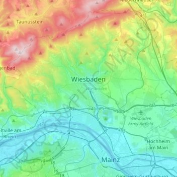
Name: Wiesbaden topographic map, elevation, terrain.
Location: Wiesbaden, Hesse, Germany (49.99324 8.11067 50.15181 8.38616)
Average elevation: 725 ft
Minimum elevation: 259 ft
Maximum elevation: 2,037 ft
Make a donation
Gear up for your next adventure:
As an Amazon Associate, this site earns from qualifying purchases at no extra cost to you.
Other topographic maps
Click on a map to view its topography, its elevation and its terrain.
Bad Hersfeld
Germany > Hesse > Landkreis Hersfeld-Rotenburg
The Flugplatz Johannesberg has the status of Special Airfield. The runway, some 671 m long and 18 m wide, is paved with asphalt and oriented in a north–south direction. The airfield lies on the Johannesberg in the like-named outlying centre at an elevation of 284 m above sea level.
Average elevation: 922 ft
Make a donation
Gear up for your next adventure:
As an Amazon Associate, this site earns from qualifying purchases at no extra cost to you.
Wiesbaden
The highest point of the Wiesbaden municipality is located northwest of the city center near the summit of the Hohe Wurzel, with an elevation of 608 metres (1,995 ft) above sea level. The lowest point is the harbour entrance of Schierstein at 83 metres (272 ft) above sea level. The central square (the…
Average elevation: 846 ft
Make a donation
Gear up for your next adventure:
As an Amazon Associate, this site earns from qualifying purchases at no extra cost to you.
Make a donation
Gear up for your next adventure:
As an Amazon Associate, this site earns from qualifying purchases at no extra cost to you.
Aurorahütte
Germany > Hesse > Landkreis Marburg-Biedenkopf > Gladenbach > Erdhausen
Average elevation: 978 ft
Make a donation
Gear up for your next adventure:
As an Amazon Associate, this site earns from qualifying purchases at no extra cost to you.
Make a donation
Gear up for your next adventure:
As an Amazon Associate, this site earns from qualifying purchases at no extra cost to you.
Wehener Wand und Rentmauer Wiesbaden
Germany > Hesse > Rheingau-Taunus-Kreis > Wiesbaden
Average elevation: 1,237 ft
Großer Feldberg
Germany > Hesse > Hochtaunuskreis > Schmitten im Taunus
The Großer Feldberg ('Great Field Mountain') is, at a height of 879.5 metres, the highest elevation of the Taunus mountains, and of the entire Rhenish Massif. It is situated in the Hochtaunuskreis district in Hesse, Germany.
Average elevation: 2,349 ft
Milseburg
Germany > Hesse > Landkreis Fulda
The Milseburg is an extinct volcano and at 835 metres (2,740 ft) above sea level the second highest elevation in the Hessian part of the Rhön Mountains, Germany. The hill is located east of Fulda, near the villages of Kleinsassen and Danzwiesen. It is a popular destination for hikers and bikers.…
Average elevation: 2,031 ft
Make a donation
Gear up for your next adventure:
As an Amazon Associate, this site earns from qualifying purchases at no extra cost to you.
Make a donation
Gear up for your next adventure:
As an Amazon Associate, this site earns from qualifying purchases at no extra cost to you.
Saubach und Niedgesbach bei Schmitten
Germany > Hesse > Hochtaunuskreis > Finsternthal
Average elevation: 1,801 ft
Make a donation
Gear up for your next adventure:
As an Amazon Associate, this site earns from qualifying purchases at no extra cost to you.
Wald-Michelbach
Germany > Hesse > Kreis Bergstraße > Wald-Michelbach > Wald-Michelbach
Average elevation: 1,299 ft
Make a donation
Gear up for your next adventure:
As an Amazon Associate, this site earns from qualifying purchases at no extra cost to you.
Frankershausen
Germany > Hesse > Werra-Meißner-Kreis > Berkatal > Frankershausen
Average elevation: 955 ft
Seeheim-Jugenheim
Germany > Hesse > Landkreis Darmstadt-Dieburg > Seeheim-Jugenheim > Seeheim-Jugenheim
Average elevation: 699 ft
Make a donation
Gear up for your next adventure:
As an Amazon Associate, this site earns from qualifying purchases at no extra cost to you.
Teufelskadrich bei Lorch
Germany > Hesse > Rheingau-Taunus-Kreis > Rüdesheim am Rhein > Assmannshausen
Average elevation: 830 ft