
Make a donation
Gear up for your next adventure:
As an Amazon Associate, this site earns from qualifying purchases at no extra cost to you.
Kimberley topographic map
Click on the map to display elevation.
Make a donation
Gear up for your next adventure:
As an Amazon Associate, this site earns from qualifying purchases at no extra cost to you.
Kimberley
Kimberley has a continental climate with semi-arid influences and heavy moderation from the nearby mountains which tend to block arctic air masses, and produce a rain shadow. Its fairly high elevation counters this effect slightly, as temperatures are somewhat cooler and the town slightly more rainy than it would otherwise be.
Make a donation
Gear up for your next adventure:
As an Amazon Associate, this site earns from qualifying purchases at no extra cost to you.
About this map
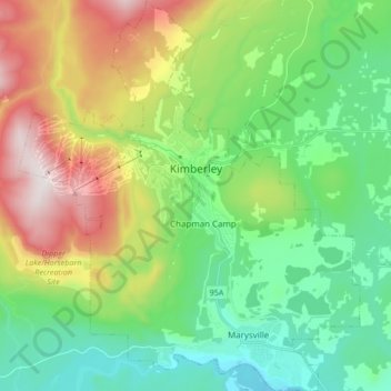
Name: Kimberley topographic map, elevation, terrain.
Average elevation: 3,990 ft
Minimum elevation: 2,884 ft
Maximum elevation: 6,250 ft
Make a donation
Gear up for your next adventure:
As an Amazon Associate, this site earns from qualifying purchases at no extra cost to you.
Other topographic maps
Click on a map to view its topography, its elevation and its terrain.
Fairmont Hot Springs
Canada > British Columbia > Regional District of East Kootenay > Area F (Columbia Lake/Windermere Lake)
Average elevation: 3,018 ft
Shuswap
Canada > British Columbia > Regional District of East Kootenay > Area F (Columbia Lake/Windermere Lake)
Average elevation: 3,038 ft
Wardner
Canada > British Columbia > Regional District of East Kootenay > Area C (Moyie/Bull River)
Average elevation: 2,674 ft
Bull Mountain
Canada > British Columbia > Regional District of East Kootenay > Area C (Moyie/Bull River)
Average elevation: 6,785 ft
Make a donation
Gear up for your next adventure:
As an Amazon Associate, this site earns from qualifying purchases at no extra cost to you.
Spillimacheen
Canada > British Columbia > Regional District of East Kootenay > Area G (Forster Creek/Mount Assiniboine)
Average elevation: 3,186 ft
The Nublet
Canada > British Columbia > Regional District of East Kootenay > Area G (Forster Creek/Mount Assiniboine)
Average elevation: 7,549 ft
Fort Steele
Canada > British Columbia > Regional District of East Kootenay > Area C (Moyie/Bull River)
Average elevation: 2,615 ft
Fording River
Canada > British Columbia > Regional District of East Kootenay > Elkford
Average elevation: 5,863 ft
Make a donation
Gear up for your next adventure:
As an Amazon Associate, this site earns from qualifying purchases at no extra cost to you.
Upper Elk Lake
Canada > British Columbia > Regional District of East Kootenay > Area A (Upper Flathead/Elk Valley)
Average elevation: 6,503 ft
Wasa Lake
Canada > British Columbia > Regional District of East Kootenay > Area E (Saint Mary/Skookumchuck) > Wasa
Average elevation: 2,602 ft
Whiteswan Lake
Canada > British Columbia > Regional District of East Kootenay > Area F (Columbia Lake/Windermere Lake)
Average elevation: 4,567 ft
Kootenay National Park
Canada > British Columbia > Regional District of East Kootenay
Kootenay National Park is a national park located in southeastern British Columbia, Canada, and is one component of the Canadian Rocky Mountain Parks World Heritage Site. The park consists of 1,406 km2 (543 sq mi) of the Canadian Rockies, including parts of the Kootenay and Park mountain ranges, the Kootenay…
Average elevation: 6,010 ft
Make a donation
Gear up for your next adventure:
As an Amazon Associate, this site earns from qualifying purchases at no extra cost to you.
Lazy Lake
Canada > British Columbia > Regional District of East Kootenay > Area E (Saint Mary/Skookumchuck)
Average elevation: 3,543 ft
Kragmont
Canada > British Columbia > Regional District of East Kootenay > Area B (Lake Koocanusa)
Average elevation: 2,585 ft
Tumbling NE5
Canada > British Columbia > Regional District of East Kootenay > Area G (Forster Creek/Mount Assiniboine)
Average elevation: 7,041 ft
Monroe Lake
Canada > British Columbia > Regional District of East Kootenay > Area C (Moyie/Bull River)
Average elevation: 3,625 ft
Make a donation
Gear up for your next adventure:
As an Amazon Associate, this site earns from qualifying purchases at no extra cost to you.
The Bugaboos
Canada > British Columbia > Regional District of East Kootenay > Area G (Forster Creek/Mount Assiniboine)
Average elevation: 7,913 ft
Purcell Mountains
Canada > British Columbia > Regional District of East Kootenay > Area G (Forster Creek/Mount Assiniboine)
Average elevation: 8,891 ft
Grizzly Peak
Canada > British Columbia > Regional District of East Kootenay > Area A (Upper Flathead/Elk Valley)
Average elevation: 6,437 ft
Morrissey Provincial Park
Canada > British Columbia > Regional District of East Kootenay > Area A (Upper Flathead/Elk Valley)
Average elevation: 3,412 ft
Make a donation
Gear up for your next adventure:
As an Amazon Associate, this site earns from qualifying purchases at no extra cost to you.
Findlay Creek
Canada > British Columbia > Regional District of East Kootenay > Area F (Columbia Lake/Windermere Lake)
Average elevation: 4,167 ft
Ta Ta Creek
Canada > British Columbia > Regional District of East Kootenay > Area E (Saint Mary/Skookumchuck)
Average elevation: 2,802 ft
Maiden Lake
Canada > British Columbia > Regional District of East Kootenay > Fernie
Average elevation: 3,428 ft
Big White Peak
Canada > British Columbia > Regional District of East Kootenay > Area B (Lake Koocanusa)
Average elevation: 6,102 ft
Make a donation
Gear up for your next adventure:
As an Amazon Associate, this site earns from qualifying purchases at no extra cost to you.
Jim Smith Lake
Canada > British Columbia > Regional District of East Kootenay > Area C (Moyie/Bull River)
Average elevation: 3,579 ft
Baynes Lake
Canada > British Columbia > Regional District of East Kootenay > Area B (Lake Koocanusa)
Average elevation: 2,612 ft
Gold Creek
Canada > British Columbia > Regional District of East Kootenay > Area B (Lake Koocanusa)
Average elevation: 2,700 ft
Barnes Lake
Canada > British Columbia > Regional District of East Kootenay > Area A (Upper Flathead/Elk Valley)
Average elevation: 6,801 ft
Make a donation
Gear up for your next adventure:
As an Amazon Associate, this site earns from qualifying purchases at no extra cost to you.
Elk River
Canada > British Columbia > Regional District of East Kootenay > Fernie
Average elevation: 3,720 ft
Moyie
Canada > British Columbia > Regional District of East Kootenay > Area C (Moyie/Bull River)
Average elevation: 3,819 ft
Tent Mountain
Canada > British Columbia > Regional District of East Kootenay > Area A (Upper Flathead/Elk Valley)
Average elevation: 6,145 ft
Rocky Mountains
Canada > British Columbia > Regional District of East Kootenay > Area A (Upper Flathead/Elk Valley)
Average elevation: 7,083 ft
Make a donation
Gear up for your next adventure:
As an Amazon Associate, this site earns from qualifying purchases at no extra cost to you.
Mount Fernie
Canada > British Columbia > Regional District of East Kootenay > Area A (Upper Flathead/Elk Valley)
Average elevation: 5,919 ft
Grave Lake
Canada > British Columbia > Regional District of East Kootenay > Area A (Upper Flathead/Elk Valley)
Average elevation: 4,678 ft
Mount Farnham
Canada > British Columbia > Regional District of East Kootenay > Area G (Forster Creek/Mount Assiniboine)
Average elevation: 9,157 ft
Mount Strachan
Canada > British Columbia > Regional District of East Kootenay > Area A (Upper Flathead/Elk Valley)
Average elevation: 7,211 ft
Make a donation
Gear up for your next adventure:
As an Amazon Associate, this site earns from qualifying purchases at no extra cost to you.
Mount Worthington
Canada > British Columbia > Regional District of East Kootenay > Area F (Columbia Lake/Windermere Lake)
Average elevation: 7,943 ft
Steeples
Canada > British Columbia > Regional District of East Kootenay > Cranbrook
Average elevation: 3,084 ft
Mount Bisaro
Canada > British Columbia > Regional District of East Kootenay > Area C (Moyie/Bull River)
Average elevation: 6,939 ft
Baptiste Lake
Canada > British Columbia > Regional District of East Kootenay > Area G (Forster Creek/Mount Assiniboine)
Average elevation: 3,501 ft
Make a donation
Gear up for your next adventure:
As an Amazon Associate, this site earns from qualifying purchases at no extra cost to you.
Elko
Canada > British Columbia > Regional District of East Kootenay > Area B (Lake Koocanusa)
Average elevation: 3,333 ft
Fernie
Canada > British Columbia > Regional District of East Kootenay > Fernie
Average elevation: 5,089 ft
Elkford
Canada > British Columbia > Regional District of East Kootenay > Elkford > Elkford
Average elevation: 5,066 ft
Mount Erickson
Canada > British Columbia > Regional District of East Kootenay > Area A (Upper Flathead/Elk Valley)
Average elevation: 6,358 ft
Make a donation
Gear up for your next adventure:
As an Amazon Associate, this site earns from qualifying purchases at no extra cost to you.
Caribou Park
Canada > British Columbia > Regional District of East Kootenay > Elkford
Average elevation: 4,341 ft
Cobb Lake
Canada > British Columbia > Regional District of East Kootenay > Area G (Forster Creek/Mount Assiniboine)
Average elevation: 4,482 ft
Redding Creek
Canada > British Columbia > Regional District of East Kootenay > Area E (Saint Mary/Skookumchuck)
Average elevation: 5,781 ft
Lockwood Peak
Canada > British Columbia > Regional District of East Kootenay > Area F (Columbia Lake/Windermere Lake)
Average elevation: 7,300 ft
Make a donation
Gear up for your next adventure:
As an Amazon Associate, this site earns from qualifying purchases at no extra cost to you.
Purcell Mountains
Canada > British Columbia > Regional District of East Kootenay > Area G (Forster Creek/Mount Assiniboine)
Average elevation: 8,891 ft
Panorama Mountain Village
Canada > British Columbia > Regional District of East Kootenay > Area F (Columbia Lake/Windermere Lake)
Average elevation: 4,633 ft
Grasmere
Canada > British Columbia > Regional District of East Kootenay > Area B (Lake Koocanusa)
Average elevation: 3,501 ft
Rocky Mountains
Canada > British Columbia > Regional District of East Kootenay > Area A (Upper Flathead/Elk Valley)
Average elevation: 7,083 ft
Make a donation
Gear up for your next adventure:
As an Amazon Associate, this site earns from qualifying purchases at no extra cost to you.
Valley of the Rocks
Canada > British Columbia > Regional District of East Kootenay > Area G (Forster Creek/Mount Assiniboine)
Average elevation: 7,211 ft
Mount Allen
Canada > British Columbia > Regional District of East Kootenay > Area G (Forster Creek/Mount Assiniboine)
Average elevation: 8,773 ft
Mount Strachan
Canada > British Columbia > Regional District of East Kootenay > Area A (Upper Flathead/Elk Valley)
Average elevation: 7,211 ft
Wilmer
Canada > British Columbia > Regional District of East Kootenay > Area G (Forster Creek/Mount Assiniboine)
Average elevation: 2,890 ft
Make a donation
Gear up for your next adventure:
As an Amazon Associate, this site earns from qualifying purchases at no extra cost to you.
Windermere
Canada > British Columbia > Regional District of East Kootenay > Area F (Columbia Lake/Windermere Lake)
Average elevation: 2,762 ft