
Make a donation
Gear up for your next adventure:
As an Amazon Associate, this site earns from qualifying purchases at no extra cost to you.
Cotahuasi topographic map
Click on the map to display elevation.
Make a donation
Gear up for your next adventure:
As an Amazon Associate, this site earns from qualifying purchases at no extra cost to you.
Cotahuasi
Tiene como capital a la Villa de Cotahuasi, que es también capital de la Provincia de La Unión. La Villa se encuentra a una altitud de 2680 m s. n. m.]] y a 379 km de la ciudad de Arequipa. El camino se encuentra cargado de una gran variedad de paisajes con la presencia de los Nevados: Coropuna, Solimana y Sara Sara.
Make a donation
Gear up for your next adventure:
As an Amazon Associate, this site earns from qualifying purchases at no extra cost to you.
About this map
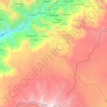
Name: Cotahuasi topographic map, elevation, terrain.
Location: Cotahuasi, La Unión, Arequipa, Perú (-15.40633 -72.94180 -15.18048 -72.78667)
Average elevation: 13,474 ft
Minimum elevation: 5,909 ft
Maximum elevation: 19,688 ft
Make a donation
Gear up for your next adventure:
As an Amazon Associate, this site earns from qualifying purchases at no extra cost to you.
Other topographic maps
Click on a map to view its topography, its elevation and its terrain.
Valle del Colca
Perú > Arequipa > Choco > Soro
El Altiplano en el Colca está representado por una extensa meseta que se desarrolla a altitudes entre 4000 y 4500 m s. n. m.. Ésta es una superficie casi llana o suavemente ondulada, sobre la cual destacan cerros y volcanes que sobrepasan los 5000 m s. n. m.. Es en estas superficies donde sobresalen volcanes…
Average elevation: 10,397 ft
Make a donation
Gear up for your next adventure:
As an Amazon Associate, this site earns from qualifying purchases at no extra cost to you.
Make a donation
Gear up for your next adventure:
As an Amazon Associate, this site earns from qualifying purchases at no extra cost to you.
Make a donation
Gear up for your next adventure:
As an Amazon Associate, this site earns from qualifying purchases at no extra cost to you.
El Pedregal
El Pedregal es una localidad peruana, capital del distrito de Majes, ubicado en la provincia de Caylloma, en el departamento de Arequipa. Se encuentra a una altitud de 1410 m s. n. m. Tenía una población de 2573 hab. en 1993.
Average elevation: 4,554 ft
Make a donation
Gear up for your next adventure:
As an Amazon Associate, this site earns from qualifying purchases at no extra cost to you.
Make a donation
Gear up for your next adventure:
As an Amazon Associate, this site earns from qualifying purchases at no extra cost to you.
Make a donation
Gear up for your next adventure:
As an Amazon Associate, this site earns from qualifying purchases at no extra cost to you.
Make a donation
Gear up for your next adventure:
As an Amazon Associate, this site earns from qualifying purchases at no extra cost to you.
Make a donation
Gear up for your next adventure:
As an Amazon Associate, this site earns from qualifying purchases at no extra cost to you.
Ampato
El Ampato (del aimara jamp'atu, 'sapo') es un volcán inactivo localizado en la Cordillera de Ampato al sur del Perú, en el distrito de Lluta. Tiene una altitud de 6.290 m s. n. m. Cerca de la cumbre de este nevado fue descubierto un cadáver congelado en septiembre de 1995 por el arqueólogo de montaña…
Average elevation: 18,976 ft
Make a donation
Gear up for your next adventure:
As an Amazon Associate, this site earns from qualifying purchases at no extra cost to you.
Make a donation
Gear up for your next adventure:
As an Amazon Associate, this site earns from qualifying purchases at no extra cost to you.
Make a donation
Gear up for your next adventure:
As an Amazon Associate, this site earns from qualifying purchases at no extra cost to you.
Make a donation
Gear up for your next adventure:
As an Amazon Associate, this site earns from qualifying purchases at no extra cost to you.
Make a donation
Gear up for your next adventure:
As an Amazon Associate, this site earns from qualifying purchases at no extra cost to you.
Make a donation
Gear up for your next adventure:
As an Amazon Associate, this site earns from qualifying purchases at no extra cost to you.
Make a donation
Gear up for your next adventure:
As an Amazon Associate, this site earns from qualifying purchases at no extra cost to you.
Mirador Cruz del Condor
Perú > Arequipa > Cabanaconde > Cabanaconde > San Miguel
Average elevation: 11,657 ft
Make a donation
Gear up for your next adventure:
As an Amazon Associate, this site earns from qualifying purchases at no extra cost to you.
Make a donation
Gear up for your next adventure:
As an Amazon Associate, this site earns from qualifying purchases at no extra cost to you.
Make a donation
Gear up for your next adventure:
As an Amazon Associate, this site earns from qualifying purchases at no extra cost to you.
Ciudad Satélite
Perú > Arequipa > José Luis Bustamante y Rivero > Ciudad Satélite
Average elevation: 7,785 ft
Make a donation
Gear up for your next adventure:
As an Amazon Associate, this site earns from qualifying purchases at no extra cost to you.
Make a donation
Gear up for your next adventure:
As an Amazon Associate, this site earns from qualifying purchases at no extra cost to you.
Make a donation
Gear up for your next adventure:
As an Amazon Associate, this site earns from qualifying purchases at no extra cost to you.
Make a donation
Gear up for your next adventure:
As an Amazon Associate, this site earns from qualifying purchases at no extra cost to you.
Make a donation
Gear up for your next adventure:
As an Amazon Associate, this site earns from qualifying purchases at no extra cost to you.
Make a donation
Gear up for your next adventure:
As an Amazon Associate, this site earns from qualifying purchases at no extra cost to you.
Make a donation
Gear up for your next adventure:
As an Amazon Associate, this site earns from qualifying purchases at no extra cost to you.