
Mesopotamia topographic map
Interactive map
Click on the map to display elevation.
About this map
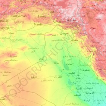
Name: Mesopotamia topographic map, elevation, terrain.
Location: Mesopotamia, Iraq (30.91048 37.83444 38.89591 47.45340)
Average elevation: 2,375 ft
Minimum elevation: 3 ft
Maximum elevation: 11,942 ft
Other topographic maps
Click on a map to view its topography, its elevation and its terrain.
Nimrud
Iraq > Nineveh Governorate > Qaryat an Namaniyah
Subsequent work was by the Directorate of Antiquities of the Republic of Iraq (1956, 1959–60, 1969–78 and 1982–92), the Polish Centre of Mediterranean Archaeology University of Warsaw directed by Janusz Meuszyński (1974–76), Paolo Fiorina (1987–89) with the Centro Ricerche Archeologiche e Scavi di…
Average elevation: 666 ft
Halabja
Halabja is located in the Shahrizor plain, a fertile valley nestled in the foothills of the Zagros Mountains in the Kurdistan Region of Iraq. The city's elevation is around 700 meters above sea level. The surrounding area is characterized by mountainous terrain, with the Hawraman Mountain range to the east,…
Average elevation: 2,956 ft
Al Mawsil al Jadidah
Iraq > Nineveh Governorate > Mosul > Al Mawsil al Jadidah
Average elevation: 843 ft
Babylon
Iraq > Babil Governorate > Qaryat Annan
A topographical survey at the site was conducted in 1974, followed in 1977 by a review of the stratigraphical position of the main monuments and reconsideration of ancient water levels, by the Turin Centre for Archaeological Research and Excavations in the Middle East and Asia, and the Iraqi-Italian Institute…
Average elevation: 105 ft