
Make a donation
Gear up for your next adventure:
As an Amazon Associate, this site earns from qualifying purchases at no extra cost to you.
Ebracher Forst topographic map
Click on the map to display elevation.
Make a donation
Gear up for your next adventure:
As an Amazon Associate, this site earns from qualifying purchases at no extra cost to you.
About this map
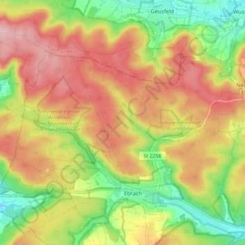
Name: Ebracher Forst topographic map, elevation, terrain.
Location: Ebracher Forst, Landkreis Bamberg, Bayern, Deutschland (49.84725 10.44439 49.87877 10.52696)
Average elevation: 1,293 ft
Minimum elevation: 1,001 ft
Maximum elevation: 1,562 ft
Make a donation
Gear up for your next adventure:
As an Amazon Associate, this site earns from qualifying purchases at no extra cost to you.
Other topographic maps
Click on a map to view its topography, its elevation and its terrain.
Make a donation
Gear up for your next adventure:
As an Amazon Associate, this site earns from qualifying purchases at no extra cost to you.
Ludwag
Deutschland > Bayern > Landkreis Bamberg > Scheßlitz
Ludwag liegt auf einer Anhöhe an der Straße, die von Scheßlitz nach Heiligenstadt führt. Unterhalb der Ortschaft liegt ein ausgedehnter stillgelegter Kalksteinbruch. Auf einem Berg in der Nähe von Ludwag befindet sich die Wallfahrtskirche Gügel. Benachbarte Ortschaften sind Neudorf, Poxdorf, Kübelstein…
Average elevation: 1,677 ft
Make a donation
Gear up for your next adventure:
As an Amazon Associate, this site earns from qualifying purchases at no extra cost to you.
Mürsbach
Deutschland > Bayern > Landkreis Bamberg > Mürsbach
Mürsbach liegt im oberfränkischen Itzgrund ca. 20 km nordwestlich von Bamberg am Rand des Naturparks Haßberge. Der lang gestreckte Höhenrücken der Zeilberge trennt hier die eigentlichen Haßberge vom Itzgrund. Die Siedlung wurde am Fuß des Bergzuges im Tälchen des Mürsbachs und in der Itzaue angelegt,…
Average elevation: 997 ft
Teuchatz
Deutschland > Bayern > Landkreis Bamberg > Heiligenstadt i. OFr.
Teuchatz hat 221 Einwohner, liegt auf 545 m ü. NN und ist damit eine der am höchsten gelegenen Ortschaften im Landkreis Bamberg. Die Ortschaft liegt in einer kleinen Senke (545 Meter über Normalnull) am Rande des westlichen Höhenzugs der Fränkischen Alb. Am Ortsrand steigt das Gelände mit dem Veitsknock…
Average elevation: 1,657 ft
Make a donation
Gear up for your next adventure:
As an Amazon Associate, this site earns from qualifying purchases at no extra cost to you.
Demmelsdorf
Deutschland > Bayern > Landkreis Bamberg > Scheßlitz > Demmelsdorf
Das Dorf hatte bis zur Zeit des Nationalsozialismus eine starke jüdische Bevölkerung. Auf einer Anhöhe über Demmelsdorf befindet sich noch ein gut erhaltener Judenfriedhof.
Average elevation: 1,306 ft
Neumühle
Deutschland > Bayern > Landkreis Bamberg > Heiligenstadt i. OFr. > Heiligenstadt i.OFr.
Neumühle liegt auf etwa 370 Meter Höhe am Volletsbach. Oberhalb der Ortschaft steht das Schloss Greifenstein. Nachbarorte sind im Norden Reckendorf, im Nordosten Schloss Greifenstein, im Süden Heiligenstadt und im Südwesten Zoggendorf.
Average elevation: 1,486 ft
Pausdorf
Deutschland > Bayern > Landkreis Bamberg > Scheßlitz
Das Dorf liegt in der Fränkischen Alb, etwa vier Kilometer nördlich von Scheßlitz im Tal des Krebsbaches auf einer Höhe von 392 m ü. NN.
Average elevation: 1,339 ft
Make a donation
Gear up for your next adventure:
As an Amazon Associate, this site earns from qualifying purchases at no extra cost to you.
Bischberg
Deutschland > Bayern > Landkreis Bamberg
Bischberg wurde 1013 durch König Heinrich II. erstmals urkundlich als „Biscoffesberge“ erwähnt. Die erste Siedlung wurde wohl auf einer Anhöhe errichtet, wovon sich der Ortsname ableitet.
Average elevation: 843 ft
Veilbronn
Deutschland > Bayern > Landkreis Bamberg > Heiligenstadt i. OFr.
Average elevation: 1,391 ft
Make a donation
Gear up for your next adventure:
As an Amazon Associate, this site earns from qualifying purchases at no extra cost to you.
Make a donation
Gear up for your next adventure:
As an Amazon Associate, this site earns from qualifying purchases at no extra cost to you.
Hohenpölz
Deutschland > Bayern > Landkreis Bamberg > Heiligenstadt i. OFr.
Der 30 Meter hohe, massiv wirkende Glockenturm der Kirche mit seiner Zwiebelhaube ist fast von überall auf den Höhen des Fränkischen Juras als Orientierung zu sehen. Hohenpölz liegt am nördlichen Ende des Markts Heiligenstadt. Nachbarorte sind (im Uhrzeigersinn) Laibarös, Huppendorf, Voitmannsdorf,…
Average elevation: 1,565 ft
Make a donation
Gear up for your next adventure:
As an Amazon Associate, this site earns from qualifying purchases at no extra cost to you.
Make a donation
Gear up for your next adventure:
As an Amazon Associate, this site earns from qualifying purchases at no extra cost to you.
Make a donation
Gear up for your next adventure:
As an Amazon Associate, this site earns from qualifying purchases at no extra cost to you.
Make a donation
Gear up for your next adventure:
As an Amazon Associate, this site earns from qualifying purchases at no extra cost to you.
Steppach
Deutschland > Bayern > Landkreis Bamberg
Die als Naturdenkmal geschützte Stieleiche – mit einem Brusthöhenumfang von 7,50 m (2016) – steht direkt über einem von A. Volland im 19. Jahrhundert erbauten Bierkeller.
Average elevation: 955 ft
Make a donation
Gear up for your next adventure:
As an Amazon Associate, this site earns from qualifying purchases at no extra cost to you.
Make a donation
Gear up for your next adventure:
As an Amazon Associate, this site earns from qualifying purchases at no extra cost to you.
Make a donation
Gear up for your next adventure:
As an Amazon Associate, this site earns from qualifying purchases at no extra cost to you.
Thüngbach
Deutschland > Bayern > Landkreis Bamberg > Thüngbach
Das Dorf liegt am Rande des Mittleren Steigerwaldes. Im Norden grenzen bewaldete Anhöhen an, im Süden fällt die aus Acker- und Grünland bestehende Gegend flach ab. Durch den Ort fließt der Thüngbach, ein linker Zufluss der Reichen Ebrach. Die Staatsstraße 2262 verläuft nach Schlüsselfeld (2,3 km…
Average elevation: 1,165 ft
Obermelsendorf
Deutschland > Bayern > Landkreis Bamberg > Schlüsselfeld > Obermelsendorf
Average elevation: 1,165 ft
Make a donation
Gear up for your next adventure:
As an Amazon Associate, this site earns from qualifying purchases at no extra cost to you.
Kleingressingen
Deutschland > Bayern > Landkreis Bamberg > Kleingressingen
Average elevation: 1,322 ft
Make a donation
Gear up for your next adventure:
As an Amazon Associate, this site earns from qualifying purchases at no extra cost to you.
Priegendorf
Deutschland > Bayern > Landkreis Bamberg > Baunach > Priegendorf
Average elevation: 1,099 ft
Seigendorf
Deutschland > Bayern > Landkreis Bamberg > Hirschaid
Es liegt östlich von Hirschaid. Über die Kreisstraße BA 27 erreicht man nach einem Kilometer die Einfahrt Hirschaid der A 73. Durch den östlichen Ortsbereich verläuft die Staatsstraße 2210. Seigendorf liegt auf einer durchschnittlichen Höhe von 273 Metern über dem Meeresspiegel.
Average elevation: 1,047 ft
Hartlanden
Deutschland > Bayern > Landkreis Bamberg > Hartlanden
Auf einer kleinen Anhöhe des Aurachtals, etwa sechs Kilometer südwestlich der Domstadt Bamberg, liegt abseits belebter Straßen die Ortschaft Hartlanden. Der Birkacher Wald und das Spitalholz grenzen als Ausläufer des Steigerwalds an die Hartlandener Flur. Ein namenloser Bach entspringt im Südwesten,…
Average elevation: 974 ft
Make a donation
Gear up for your next adventure:
As an Amazon Associate, this site earns from qualifying purchases at no extra cost to you.
Heroldsmühle
Deutschland > Bayern > Landkreis Bamberg > Oberleinleiter > Heroldsmühle
Average elevation: 1,519 ft
Leesten
Deutschland > Bayern > Landkreis Bamberg > Leesten
Leesten hat eine Höhe von ungefähr 300 m ü. NN. und liegt an den Staatsstraßen 2188 und 2210. 2010 wurden in Leesten 259 Einwohner gezählt.
Average elevation: 1,178 ft
Siegritz
Deutschland > Bayern > Landkreis Bamberg
Siegritz liegt in der Nähe des Werntals auf der Albhochfläche auf etwa 456 Meter Höhe im äußersten Südosten des Landkreises Bamberg.
Average elevation: 1,447 ft
Make a donation
Gear up for your next adventure:
As an Amazon Associate, this site earns from qualifying purchases at no extra cost to you.
Güntersdorf
Deutschland > Bayern > Landkreis Bamberg > Schlüsselfeld > Lach
Average elevation: 1,043 ft
Make a donation
Gear up for your next adventure:
As an Amazon Associate, this site earns from qualifying purchases at no extra cost to you.