
牡丹江市 topographic map
Interactive map
Click on the map to display elevation.
About this map
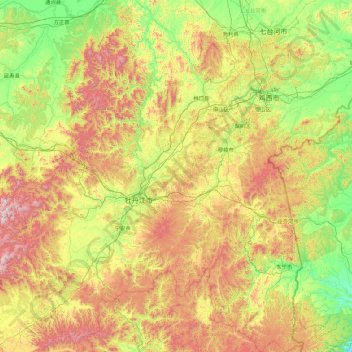
Name: 牡丹江市 topographic map, elevation, terrain.
Location: 牡丹江市, 黑龙江省, 中国 (43.42323 128.22440 45.98582 131.31383)
Average elevation: 1,467 ft
Minimum elevation: 3 ft
Maximum elevation: 5,436 ft
全市平均海拔230米,地形則是以山地,丘陵爲主,呈現出中山、低山、丘陵、河谷盆地四種地質形態,城市東部爲屬于長白山系的老爺嶺和張廣才岭,中部是牡丹江河谷盆地,整個地區凸現山勢幷且連綿起伏,亦縱橫河流,被稱爲「九分山水一分田」。
Other topographic maps
Click on a map to view its topography, its elevation and its terrain.