
讷河市 topographic map
Interactive map
Click on the map to display elevation.
About this map
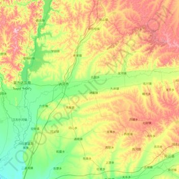
Name: 讷河市 topographic map, elevation, terrain.
Location: 讷河市, 齐齐哈尔市, 黑龙江省, 161000, 中国 (47.96285 124.30997 48.92159 125.98072)
Average elevation: 856 ft
Minimum elevation: 528 ft
Maximum elevation: 1,575 ft
Other topographic maps
Click on a map to view its topography, its elevation and its terrain.