
新平彝族傣族自治县 topographic map
Interactive map
Click on the map to display elevation.
About this map
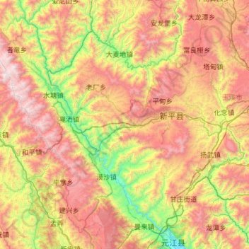
Name: 新平彝族傣族自治县 topographic map, elevation, terrain.
Location: 新平彝族傣族自治县, 玉溪市, 云南省, 中国 (23.63533 101.27532 24.43172 102.28219)
Average elevation: 4,928 ft
Minimum elevation: 1,237 ft
Maximum elevation: 10,262 ft
地处哀牢山脉中段,海拔2500~3000米的山峰有81座,海拔高于3000米的山峰有11座。境内有戛洒江和平甸河。
Other topographic maps
Click on a map to view its topography, its elevation and its terrain.