
Dang topographic map
Interactive map
Click on the map to display elevation.
About this map
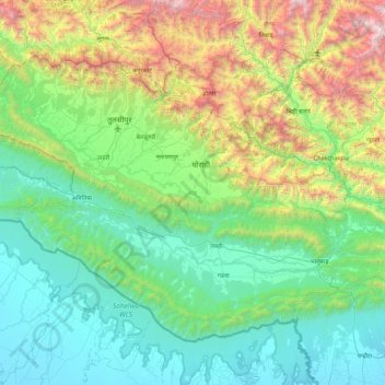
Name: Dang topographic map, elevation, terrain.
Location: Dang, Lumbini Province, Nepal (27.67644 81.92083 28.28303 82.81032)
Average elevation: 2,448 ft
Minimum elevation: 358 ft
Maximum elevation: 9,560 ft
The Dudhwas rise steeply to a crest at about 700 meters, then slope more gradually into the Deukhuri Valley, down to 250 meters elevation at the Rapti River. The Dudhwas extend more than 100 km, causing the Rapti to detour west around them before turning southeast down the main trend of the plains into India. Deukhuri's climate is nearly tropical and it is well watered by the river, as well as possessing abundant groundwater. North of Deukhuri Valley, the Dang Range rises as high as 1,000 meters with passes at about 700 meters. The Dang Valley lies north of these hills, drained by the Babai River tributary to the Ghaghara (Karnali). Valley elevations range from 600 meters along the Babai with alluvial slopes gradually rising northward to 700 meters along the base of the Mahabharat Range. The district then extends upslope to the crest of the Mahabharats at 1,500 to 1,700 meters elevation. The bordering districts to the north are Pyuthan, Rolpa, and Salyan. The Rapti River of Western Nepal traverses through most of the lower Dang valley. It flows beneath the Churia range first on the northern side of the hills and then leaves the hills on the southern side. Nepal's second-longest bridge over Rapti river in Dang district connects Sisahaniya of Rapti Rural Municipality with Mahadeva of Gadawa Rural Municipality in the district.
Other topographic maps
Click on a map to view its topography, its elevation and its terrain.
Mount Everest
Nepal > Eastern Development Region > Khumjung
Mount Everest, Khumjung, Solukhumbu, Sagarmatha, Eastern Development Region, Nepal
Average elevation: 25,725 ft
Himalayas
Nepal > Koshi Province > Solukhumbu
Himalayas, Khumbupasanglahmu, Solukhumbu, Koshi Province, Nepal
Average elevation: 24,787 ft
Pokhara
Nepal > Gandaki Province > Kaski
Pokhara, Kaski, Gandaki Province, Nepal
Average elevation: 3,947 ft
Kathmandu
Nepal > Bagmati Province > Kathmandu
Kathmandu, Kathmandu Metropolitan City, Kathmandu, Bagmati Province, 46000, Nepal
Average elevation: 5,046 ft
Mount Everest
Nepal > Koshi Province > Solukhumbu
Mount Everest, Khumbupasanglahmu, Solukhumbu, Koshi Province, Nepal
Average elevation: 25,755 ft
Kāgbeni
Nepal > Gandaki Province > Mustang
Kāgbeni, Barhagaun Muktikhsetra, Mustang, Gandaki Province, Nepal
Average elevation: 10,174 ft
Chure
Nepal > Sudurpashchim Province > Kailali
Chure, Kailali, Sudurpashchim Province, Nepal
Average elevation: 3,081 ft
Pokhariya
Nepal > Madhesh Province > Parsa
Pokhariya, Parsa, Madhesh Province, Nepal
Average elevation: 285 ft
singdi village
Nepal > Gandaki Province > Kaski > Bhachok
singdi village, Bhachok to Nagidhar, Madi-08, Bhachok, Madi, Kaski, Gandaki Province, Nepal
Average elevation: 4,587 ft
Panauti
Nepal > Bagmati Province > Kavrepalanchok
Panauti, Paunauti, Kavrepalanchok, Bagmati Province, 45209, Nepal
Average elevation: 5,177 ft
Arun River
Nepal > Koshi Province > Sankhuwasabha > Num
Arun River, Makalu-02, Num, Makalu, Sankhuwasabha, Koshi Province, Nepal
Average elevation: 3,783 ft
Mount Everest
Nepal > Koshi Province > Solukhumbu
Mount Everest, Khumbupasanglahmu, Solukhumbu, Koshi Province, Nepal
Average elevation: 25,745 ft
Chitrey
Nepal > Koshi Province > Ilam
Chitrey, 03DR021, Suryodaya-01, Suryodaya, Ilam, Koshi Province, 57303, Nepal
Average elevation: 6,893 ft
Triveni-01
Nepal > Lumbini Province > Rolpa
Triveni-01, Tribeni, Rolpa, Lumbini Province, Nepal
Average elevation: 4,662 ft
Patahrishanishchare
Nepal > Koshi Province > Morang
Patahrishanishchare, Morang, Koshi Province, Nepal
Average elevation: 361 ft
Seram
Nepal > Lumbini Province > Rolpa
Seram, Sunchhahari-01, Sunchhahari, Rolpa, Lumbini Province, Nepal
Average elevation: 5,653 ft
Bat Cave
Nepal > Gandaki Province > Kaski > Pokhara
Bat Cave, Pokhara-19, Pokhara, Kaski, Gandaki Province, Nepal
Average elevation: 3,350 ft
Itahari
Nepal > Koshi Province > Sunsari
Itahari, Sunsari, Koshi Province, 56705, Nepal
Average elevation: 525 ft
Sundarharaicha
Nepal > Koshi Province > Morang
Sundarharaicha, Morang, Koshi Province, 56611, Nepal
Average elevation: 413 ft
Tarakeshwar
Nepal > Bagmati Province > Kathmandu
Tarakeshwar, Tarakeshwar Municipality, Kathmandu, Bagmati Province, 44610, Nepal
Average elevation: 4,583 ft
Uwa
Nepal > Lumbini Province > Rolpa
Uwa, Thabang-05, Thawang, Rolpa, Lumbini Province, Nepal
Average elevation: 7,093 ft
Tilottama
Nepal > Lumbini Province > Rupandehi
Tilottama, Rupandehi, Lumbini Province, Nepal
Average elevation: 410 ft
Kapuche Glacier Lake
Nepal > Gandaki Province > Kaski
Kapuche Glacier Lake, Parche - Namarjung, Madi-02, Madi, Kaski, Gandaki Province, Nepal
Average elevation: 9,541 ft
Nepalgunj
Nepal > Lumbini Province > Banke
Nepalgunj, NSMC-24 | Khas Karkando, Banke, Lumbini Province, 22010, Nepal
Average elevation: 492 ft
Rupa Lake
Nepal > Gandaki Province > Kaski > Pokhara
Rupa Lake, Rupa-06, Pokhara, Rupa, Kaski, Gandaki Province, Nepal
Average elevation: 2,411 ft
Banke National Park
Nepal > Lumbini Province > Banke
Banke National Park, Banke, Lumbini Province, Nepal
Average elevation: 1,627 ft
Kapilbastu
Nepal > Lumbini Province > Kapilvastu
Kapilbastu, Kapilvastu, Lumbini Province, Nepal
Average elevation: 344 ft
Parche - Namarjung
Nepal > Gandaki Province > Kaski
Parche - Namarjung, Madi-02, Madi, Kaski, Gandaki Province, Nepal
Average elevation: 13,829 ft
Halesi
Nepal > Koshi Province > Khotang
Halesi, Halesi Tuwachung, Khotang, Koshi Province, Nepal
Average elevation: 3,855 ft
Jiri
Nepal > Bagmati Province > Dolakha
Jiri, Dolakha, Bagmati Province, 45503, Nepal
Average elevation: 8,189 ft
Gaurishankar
Nepal > Bagmati Province > Dolakha
Gaurishankar, Dolakha, Bagmati Province, Nepal
Average elevation: 11,883 ft
Butwal
Nepal > Lumbini Province > Rupandehi
Butwal, Rupandehi, Lumbini Province, 32907, Nepal
Average elevation: 919 ft
Hetauda
Nepal > Bagmati Province > Makwanpur
Hetauda, Makwanpur, Bagmati Province, 40400, Nepal
Average elevation: 2,589 ft
Kanchan
Nepal > Lumbini Province > Rupandehi
Kanchan, Rupandehi, Lumbini Province, Nepal
Average elevation: 407 ft
Dogahara
Nepal > Lumbini Province > Rupandehi > Siddhartanagar
Dogahara, Siddharthanagar-04, Siddhartanagar, Siddharthanagar, Rupandehi, Lumbini Province, 32900, Nepal
Average elevation: 348 ft
Putha Uttarganga
Nepal > Lumbini Province > Eastern Rukum
Putha Uttarganga, Eastern Rukum, Lumbini Province, Nepal
Average elevation: 9,511 ft
Dharapani
Nepal > Gandaki Province > Manang
Dharapani, Nashong, Manang, Gandaki Province, 33500, Nepal
Average elevation: 8,284 ft
Dumre
Nepal > Gandaki Province > Tanahun
Dumre, Bhanu, Tanahun, Gandaki Province, Nepal
Average elevation: 2,031 ft
Diktel
Nepal > Koshi Province > Khotang
Diktel, Rupakot Majhuwagadhi, Khotang, Koshi Province, Nepal
Average elevation: 4,895 ft
Kohalpur
Nepal > Lumbini Province > Banke
Kohalpur, Banke, Lumbini Province, 21904, Nepal
Average elevation: 846 ft
Hiunchuli
Nepal > Gandaki Province > Kaski
Hiunchuli, Annapurna, Kaski, Gandaki Province, Nepal
Average elevation: 17,913 ft
Pathari
Nepal > Koshi Province > Morang
Pathari, Patahrishanishchare, Morang, Koshi Province, 56600, Nepal
Average elevation: 456 ft