Geolocate

Paint Lake topographic map

Click on the map to display elevation.

About this map

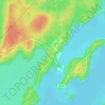
Name: Paint Lake topographic map, elevation, terrain.

Location: Paint Lake, Manitoba, Canada (55.48614 -98.03971 55.50614 -98.01971)

Average elevation: 650 ft

Minimum elevation: 597 ft

Maximum elevation: 741 ft

Other topographic maps

Click on a map to view its topography, its elevation and its terrain.

Winnipeg

Canada > Manitoba

Winnipeg lies at the bottom of the Red River Valley, a flood plain with an extremely flat topography. It is on the eastern edge of the Canadian Prairies in Western Canada and is known as the "Gateway to the West". Winnipeg is bordered by tallgrass prairie to the west and south and the aspen parkland to the…

Average elevation: 774 ft

Assiniboine River

Canada > Manitoba

Average elevation: 1,578 ft

Lake Manitoba

Canada > Manitoba

Average elevation: 978 ft

Lake Winnipeg

Canada > Manitoba

Average elevation: 902 ft

Brandon

Canada > Manitoba > Brandon

Average elevation: 1,289 ft

Rural Municipality of Stuartburn

Canada > Manitoba

Average elevation: 1,004 ft

Neepawa

Canada > Manitoba

Average elevation: 1,214 ft

Rural Municipality of Lakeshore

Canada > Manitoba

Average elevation: 971 ft

Cartwright – Roblin Municipality

Canada > Manitoba

Average elevation: 1,519 ft

Rural Municipality of Dauphin

Canada > Manitoba

Average elevation: 1,053 ft

St. François Xavier

Canada > Manitoba

Average elevation: 797 ft

Municipality of Rhineland

Canada > Manitoba

Average elevation: 833 ft

Winnipeg River

Canada > Manitoba

Average elevation: 1,014 ft

Riding Mountain National Park

Canada > Manitoba > Dauphin

The climate in the Riding Mountain region is similar to that of other regions of southwestern Manitoba. Under the Köppen classification it has a continental climate. It includes grasslands, upland boreal and eastern deciduous forest ecosystems. The park has hot summers and cold winters, with annual rainfall…

Average elevation: 1,601 ft

Rural Municipality of Mountain

Canada > Manitoba

Average elevation: 1,102 ft

Hayes River

Canada > Manitoba

Average elevation: 535 ft

Unorganized Division No. 19

Canada > Manitoba

Average elevation: 955 ft

Turtle Mountain Provincial Park

Canada > Manitoba > Municipality of Boissevain – Morton

Turtle Mountain Provincial Park is situated on the Turtle Mountain (plateau), one of a number of significant geographic features located along the Manitoba Escarpment, the Canadian portion of the Pembina Escarpment. It is located in the Southwest Manitoba Uplands Ecoregion, within the Canadian Prairies. The…

Average elevation: 2,172 ft

Lake of the Prairies

Canada > Manitoba

Average elevation: 1,647 ft

Aikens Lake

Canada > Manitoba > Unorganized Division No. 19

Average elevation: 1,037 ft

York Factory First Nation

Canada > Manitoba > York Landing

Average elevation: 610 ft

Athapapuskow Lake

Canada > Manitoba

Average elevation: 1,004 ft

Melita

Canada > Manitoba

Average elevation: 1,444 ft

Gilbert Plains Municipality

Canada > Manitoba

Average elevation: 1,352 ft

Carberry

Canada > Manitoba

Average elevation: 1,263 ft

Grandview Municipality

Canada > Manitoba

Average elevation: 1,686 ft

Powerview-Pine Falls

Canada > Manitoba

Average elevation: 745 ft

Stonewall

Canada > Manitoba

When the last ice age retreated, as well as the prairies, escarpments such as Riding Mountain were left behind. In addition to these, smaller elevations were left behind such as Stony Mountain and Stonewall. It is believed that these escarpments were used as look-outs by early hunters approximately 4,000 to…

Average elevation: 823 ft

Riding Mountain National Park

Canada > Manitoba > Municipality of Harrison Park > Wasagaming

Riding Mountain Biosphere Reserve covers 15,000 square kilometers of land in South-western Manitoba, with the core area, Riding Mountain National Park (RMNP), covering nearly 3,000 square kilometers. It is some 300 km northwest of Winnipeg, Manitoba. The local climate is cool and moist due to a higher…

Average elevation: 2,044 ft

Mink Lake

Canada > Manitoba > Unorganized Division No. 19

Average elevation: 1,070 ft

Lynn Lake

Canada > Manitoba

Average elevation: 1,158 ft

Flin Flon

Canada > Manitoba

Average elevation: 1,056 ft

Rural Municipality of Ste. Anne

Canada > Manitoba

Average elevation: 889 ft

Unorganized Division No. 19

Canada > Manitoba

Average elevation: 955 ft

Flin Flon

Canada > Manitoba

Average elevation: 1,060 ft

Rural Municipality of Reynolds

Canada > Manitoba

Average elevation: 994 ft

Leaf Rapids

Canada > Manitoba

Average elevation: 955 ft

Carberry

Canada > Manitoba

Average elevation: 1,263 ft

Dodds Lake

Canada > Manitoba > Unorganized Division No. 21

Average elevation: 1,020 ft

Rural Municipality of Alexander

Canada > Manitoba

Average elevation: 863 ft

Morden

Canada > Manitoba

Average elevation: 1,010 ft

Valley River

Canada > Manitoba

Average elevation: 1,627 ft

Carman

Canada > Manitoba

Average elevation: 869 ft

Rural Municipality of Coldwell

Canada > Manitoba

Average elevation: 853 ft

Municipality of North Norfolk

Canada > Manitoba

Average elevation: 1,037 ft

Toilers Memorial Park

Canada > Manitoba > Winnipeg

Average elevation: 768 ft

Beaumont

Canada > Manitoba > Winnipeg

Average elevation: 768 ft

Wallace Lake

Canada > Manitoba > Unorganized Division No. 19

Average elevation: 1,030 ft

Swan Lake

Canada > Manitoba > Unorganized Division No. 19

The Swan Lake drainage basin covers 3,880 square miles (10,000 km2) and extends into the province of Saskatchewan. It is located between the Duck Mountains and the Porcupine Hills. Two major rivers discharge into Swan Lake from the basin, the Swan River and the Woody River. Other topographic features include…

Average elevation: 883 ft

McKittrick Park

Canada > Manitoba > Winnipeg

Average elevation: 768 ft

Brandon

Canada > Manitoba

Average elevation: 1,293 ft

Rock Lake

Canada > Manitoba > Unorganized Division No. 1

Average elevation: 1,109 ft

Pelican Lake

Canada > Manitoba > Municipality of Killarney-Turtle Mountain

The lake is normally maintained at elevations between 411.5 and 412 metres (1,350 and 1,352 ft) above sea level during summer months. During the spring period, the lake may be raised temporarily to an elevation of 412.2 metres (1,352 ft). When the lake is low, water may be diverted from the Pembina River into…

Average elevation: 1,506 ft

Louise Lake

Canada > Manitoba > Lynn Lake

Average elevation: 1,253 ft

Swan Lake

Canada > Manitoba > Unorganized Division No. 19

Average elevation: 883 ft

Municipality of Roblin

Canada > Manitoba

Average elevation: 1,949 ft

Edgewood Park

Canada > Manitoba > Winnipeg

Average elevation: 768 ft

Municipality of Louise

Canada > Manitoba

Average elevation: 1,516 ft

Bison Run

Canada > Manitoba > Winnipeg

Average elevation: 768 ft

Municipality of Lorne

Canada > Manitoba

Average elevation: 1,444 ft

Yukon Lake

Canada > Manitoba > Unorganized Division No. 21

Average elevation: 945 ft

Churchill

Canada > Manitoba

Average elevation: 16 ft

Rural Municipality of Rosser

Canada > Manitoba

Average elevation: 791 ft

Morden

Canada > Manitoba > Morden

Average elevation: 958 ft

Sandy Lake

Canada > Manitoba

Average elevation: 2,034 ft

Caddy Lake

Canada > Manitoba > Unorganized Division No. 1

Average elevation: 1,096 ft

Gear up for your next adventure:

🥾Women's Hiking Boots - Top-rated trail boots with ankle support and superior grip
GPS Sports Watch - GPS watch for running, hiking and training
🔭Stargazing Telescopes - Perfect for camping in low-light pollution areas shown on maps
🪑Ultralight Camp Chairs - Portable seating for resting after a long day of mapping
🥘Titanium Cookware - Durable, featherlight pots and pans for backpacking

As an Amazon Associate, this site earns from qualifying purchases at no extra cost to you.