
Brandon topographic map
Click on the map to display elevation.
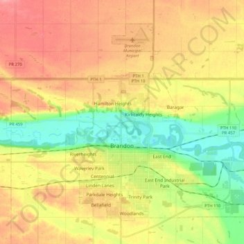
About this map
Name: Brandon topographic map, elevation, terrain.
Location: Brandon, Manitoba, Canada (49.80536 -100.00764 49.91596 -99.80605)
Average elevation: 1,293 ft
Minimum elevation: 1,165 ft
Maximum elevation: 1,394 ft
Other topographic maps
Click on a map to view its topography, its elevation and its terrain.
West Hawk Lake
Canada > Manitoba > Division No. 1 > Unorganized Division No. 1
Average elevation: 1,145 ft
Onanole
Canada > Manitoba > Division No. 15 > Municipality of Harrison Park
Average elevation: 2,057 ft
Clear Lake
Canada > Manitoba > Division No. 18 > Rural Municipality of Grahamdale
Average elevation: 823 ft
Easterville
Canada > Manitoba > Division No. 21 > Unorganized Division No. 21
Average elevation: 853 ft
Riding Mountain National Park
The climate in the Riding Mountain region is similar to that of other regions of southwestern Manitoba. Under the Köppen classification it has a continental climate. It includes grasslands, upland boreal and eastern deciduous forest ecosystems. The park has hot summers and cold winters, with annual rainfall…
Average elevation: 1,601 ft
Rowland Lake
Canada > Manitoba > Division No. 15 > Rural Municipality of Rosedale
Average elevation: 2,270 ft
Bakers Narrows
Canada > Manitoba > Division No. 21 > Unorganized Division No. 21
Average elevation: 974 ft
Elphinstone
Canada > Manitoba > Division No. 15 > Rural Municipality of Yellowhead
Average elevation: 1,913 ft
Wasagaming
Canada > Manitoba > Unorganized Division No. 17
Wasagaming has a subarctic climate (Dfc) due to its northerly location and high elevation. Winters are extremely cold and relatively dry with little chance of a mid-winter thaw. The average annual temperature is 0.7 °C (33.3 °F). Annual precipitation is 488 mm (19.2 in).
Average elevation: 2,067 ft
Red River Floodway
Canada > Manitoba > Rural Municipality of Springfield > Winnipeg
Average elevation: 774 ft