
Thompson topographic map
Click on the map to display elevation.
About this map
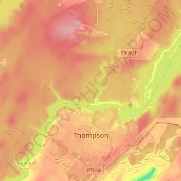
Name: Thompson topographic map, elevation, terrain.
Location: Thompson, Manitoba, Canada (55.72571 -97.89803 55.79495 -97.79272)
Average elevation: 682 ft
Minimum elevation: 449 ft
Maximum elevation: 797 ft
Other topographic maps
Click on a map to view its topography, its elevation and its terrain.
Riding Mountain National Park
The climate in the Riding Mountain region is similar to that of other regions of southwestern Manitoba. Under the Köppen classification it has a continental climate. It includes grasslands, upland boreal and eastern deciduous forest ecosystems. The park has hot summers and cold winters, with annual rainfall…
Average elevation: 1,601 ft
West Hawk Lake
Canada > Manitoba > Division No. 1 > Unorganized Division No. 1
Average elevation: 1,145 ft
Onanole
Canada > Manitoba > Division No. 15 > Municipality of Harrison Park
Average elevation: 2,057 ft
Red River Floodway
Canada > Manitoba > Rural Municipality of Springfield > Winnipeg
Average elevation: 774 ft
Clear Lake
Canada > Manitoba > Division No. 18 > Rural Municipality of Grahamdale
Average elevation: 823 ft
Easterville
Canada > Manitoba > Division No. 21 > Unorganized Division No. 21
Average elevation: 853 ft
Rowland Lake
Canada > Manitoba > Division No. 15 > Rural Municipality of Rosedale
Average elevation: 2,270 ft
Bakers Narrows
Canada > Manitoba > Division No. 21 > Unorganized Division No. 21
Average elevation: 974 ft
Elphinstone
Canada > Manitoba > Division No. 15 > Rural Municipality of Yellowhead
Average elevation: 1,913 ft
Wasagaming
Canada > Manitoba > Unorganized Division No. 17
Wasagaming has a subarctic climate (Dfc) due to its northerly location and high elevation. Winters are extremely cold and relatively dry with little chance of a mid-winter thaw. The average annual temperature is 0.7 °C (33.3 °F). Annual precipitation is 488 mm (19.2 in).
Average elevation: 2,067 ft