
Make a donation
Gear up for your next adventure:
As an Amazon Associate, this site earns from qualifying purchases at no extra cost to you.
Dundigal mandal topographic map
Click on the map to display elevation.
Make a donation
Gear up for your next adventure:
As an Amazon Associate, this site earns from qualifying purchases at no extra cost to you.
About this map
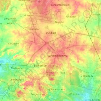
Name: Dundigal mandal topographic map, elevation, terrain.
Location: Dundigal mandal, Medchal–Malkajgiri District, Telangana, India (17.52501 78.35550 17.63962 78.50711)
Average elevation: 1,952 ft
Minimum elevation: 1,814 ft
Maximum elevation: 2,080 ft
Make a donation
Gear up for your next adventure:
As an Amazon Associate, this site earns from qualifying purchases at no extra cost to you.
Other topographic maps
Click on a map to view its topography, its elevation and its terrain.
Make a donation
Gear up for your next adventure:
As an Amazon Associate, this site earns from qualifying purchases at no extra cost to you.
Make a donation
Gear up for your next adventure:
As an Amazon Associate, this site earns from qualifying purchases at no extra cost to you.
Make a donation
Gear up for your next adventure:
As an Amazon Associate, this site earns from qualifying purchases at no extra cost to you.
Nakrekal
India > Telangana > Nakrekal mandal
Nakrekal is located at 17°09′53″N 79°25′39″E / 17.16469834°N 79.42747827°E / 17.16469834; 79.42747827. It has an average elevation of 240 metres (790 ft).
Average elevation: 679 ft
Make a donation
Gear up for your next adventure:
As an Amazon Associate, this site earns from qualifying purchases at no extra cost to you.
Make a donation
Gear up for your next adventure:
As an Amazon Associate, this site earns from qualifying purchases at no extra cost to you.
Make a donation
Gear up for your next adventure:
As an Amazon Associate, this site earns from qualifying purchases at no extra cost to you.
Make a donation
Gear up for your next adventure:
As an Amazon Associate, this site earns from qualifying purchases at no extra cost to you.
Jadcherla
India > Telangana > Jadcherla mandal
Jadcherla is located at 16°46′26″N 78°08′12″E / 16.7738°N 78.1367°E / 16.7738; 78.1367 and at an altitude of 14 m (46 ft). The town is spread over an area of 550 km2 (210 sq mi). Jadcherla is located 86 km from Hyderabad 130km from Kurnool and 21 km from Mahabubnagar.
Average elevation: 1,811 ft
Make a donation
Gear up for your next adventure:
As an Amazon Associate, this site earns from qualifying purchases at no extra cost to you.
Jagdevpur
India > Telangana > Jagdevpur mandal
Located at 17°46′05″N 78°48′29″E / 17.768°N 78.808°E / 17.768; 78.808, Jagadevpur has an average elevation of 568 metres (1,864 ft). It is the fourth-largest mandal of the Siddipet district. Jagadevpur is 70 km north of Hyderabad and 30 km each from Bhongir and the famous Yadagirigutta (Temple).
Average elevation: 1,791 ft
Make a donation
Gear up for your next adventure:
As an Amazon Associate, this site earns from qualifying purchases at no extra cost to you.
Gajwel
India > Telangana > Gajwel mandal
The town is located on the Deccan Plateau and is surrounded by agricultural lands. It lies at an average elevation of around 540 meters (1,770 feet) above sea level. The area is characterized by undulating terrain with scattered hills and valleys.
Average elevation: 1,864 ft
Make a donation
Gear up for your next adventure:
As an Amazon Associate, this site earns from qualifying purchases at no extra cost to you.
Make a donation
Gear up for your next adventure:
As an Amazon Associate, this site earns from qualifying purchases at no extra cost to you.
Make a donation
Gear up for your next adventure:
As an Amazon Associate, this site earns from qualifying purchases at no extra cost to you.
Make a donation
Gear up for your next adventure:
As an Amazon Associate, this site earns from qualifying purchases at no extra cost to you.
Make a donation
Gear up for your next adventure:
As an Amazon Associate, this site earns from qualifying purchases at no extra cost to you.
Munugode
India > Telangana > Munugode mandal
Munungode is located at 17°04′00″N 79°04′00″E / 17.0667°N 79.0667°E / 17.0667; 79.0667.[2] It has an average elevation of 241 metres (793 ft).
Average elevation: 823 ft
Kothagudem
India > Telangana > Kothagudem mandal
Kothagudem is located at 17°33′00″N 80°37′05″E / 17.55°N 80.618°E / 17.55; 80.618. It has an average elevation of 89 metres (295 ft) above sea level. The North of Kothagudem borders Chhattisgarh state which is approximately 120 km from the town.
Average elevation: 358 ft
Make a donation
Gear up for your next adventure:
As an Amazon Associate, this site earns from qualifying purchases at no extra cost to you.