
Gjøvik topographic map
Interactive map
Click on the map to display elevation.
About this map
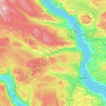
Name: Gjøvik topographic map, elevation, terrain.
Location: Gjøvik, Innlandet, Norvège (60.70747 10.16766 61.03683 10.74476)
Average elevation: 1,385 ft
Minimum elevation: 394 ft
Maximum elevation: 3,091 ft
Hovdetoppen (258 m) surplombe l'embouchure de l'Hunnselva, Bergstoppen (436 m) domine Nordbyen et Bratenghøgda (485 m) se dresse à l'est de Hunndalen. La gare de Gjøvik est située à une altitude de 129,2 mètres.
Other topographic maps
Click on a map to view its topography, its elevation and its terrain.
Trollstigen
Trollstigen, Søndre Land, Innlandet, Norvège
Average elevation: 1,506 ft
Viewpoint Snøhetta
Viewpoint Snøhetta, Vålåsjøhøvegen, Dovre, Innlandet, 2661, Norvège
Average elevation: 3,796 ft