
Vestre Slidre topographic map
Interactive map
Click on the map to display elevation.
About this map
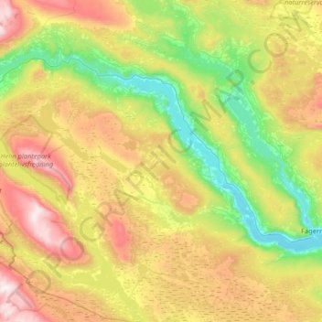
Name: Vestre Slidre topographic map, elevation, terrain.
Location: Vestre Slidre, Innlandet, Norvège (60.89663 8.65405 61.20964 9.17874)
Average elevation: 2,881 ft
Minimum elevation: 1,155 ft
Maximum elevation: 5,801 ft
Other topographic maps
Click on a map to view its topography, its elevation and its terrain.
Trollstigen
Trollstigen, Søndre Land, Innlandet, Norvège
Average elevation: 1,506 ft
Viewpoint Snøhetta
Viewpoint Snøhetta, Vålåsjøhøvegen, Dovre, Innlandet, 2661, Norvège
Average elevation: 3,796 ft