
Trysil topographic map
Interactive map
Click on the map to display elevation.
About this map
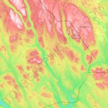
Name: Trysil topographic map, elevation, terrain.
Location: Trysil, Innlandet, Norvège (61.01308 11.73716 61.69914 12.87086)
Average elevation: 2,070 ft
Minimum elevation: 925 ft
Maximum elevation: 3,934 ft
Other topographic maps
Click on a map to view its topography, its elevation and its terrain.
Trollstigen
Trollstigen, Søndre Land, Innlandet, Norvège
Average elevation: 1,506 ft
Viewpoint Snøhetta
Viewpoint Snøhetta, Vålåsjøhøvegen, Dovre, Innlandet, 2661, Norvège
Average elevation: 3,796 ft