
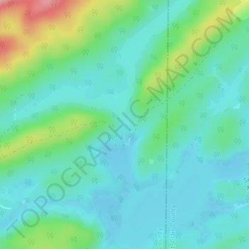
Birmingham Saw Works Lake Dam topographic map
Interactive map
Click on the map to display elevation.
About this map
Name: Birmingham Saw Works Lake Dam topographic map, elevation, terrain.
Average elevation: 636 ft
Minimum elevation: 535 ft
Maximum elevation: 961 ft
Other topographic maps
Click on a map to view its topography, its elevation and its terrain.
Pelham
United States > Alabama > Shelby County
Pelham, Shelby County, Alabama, 35124, United States
Average elevation: 568 ft
Helena
United States > Alabama > Shelby County
Helena, Shelby County, Alabama, 35080, United States
Average elevation: 535 ft
Chelsea
United States > Alabama > Shelby County
Chelsea, Shelby County, Alabama, 35050, United States
Average elevation: 587 ft
Vincent
United States > Alabama > Shelby County
Vincent, Shelby County, Alabama, 35178, United States
Average elevation: 482 ft
Harpersville
United States > Alabama > Shelby County
Harpersville, Shelby County, Alabama, 35078, United States
Average elevation: 456 ft
Wilsonville
United States > Alabama > Shelby County
Wilsonville, Shelby County, Alabama, United States
Average elevation: 456 ft
Lay lake
United States > Alabama > Shelby County
Lay lake, Shelby County, Alabama, United States
Average elevation: 492 ft
Calera
United States > Alabama > Shelby County
Calera, Shelby County, Alabama, United States
Average elevation: 568 ft
Alabaster
United States > Alabama > Shelby County
Alabaster, Shelby County, Alabama, 35007, United States
Average elevation: 568 ft
Oak Mountain State Park
United States > Alabama > Shelby County > Pelham > Indian Springs Village
Oak Mountain State Park, Indian Springs Village, Pelham, Shelby County, Alabama, United States
Average elevation: 673 ft
Pine Grove Village
United States > Alabama > Shelby County
Pine Grove Village, Shelby County, Alabama, 35143, United States
Average elevation: 440 ft
Deer Springs Estates
United States > Alabama > Shelby County > Pelham
Deer Springs Estates, Pelham, Shelby County, Alabama, 35124, United States
Average elevation: 623 ft
Helena
United States > Alabama > Shelby County
Helena, Shelby County, Alabama, United States
Average elevation: 512 ft
Chelsea
United States > Alabama > Shelby County > Chelsea
Chelsea, Shelby County, Alabama, United States
Average elevation: 699 ft
Arkwright
United States > Alabama > Shelby County > Vincent
Arkwright, Vincent, Shelby County, Alabama, 35178, United States
Average elevation: 449 ft
Inverness
United States > Alabama > Shelby County > Meadowbrook > Inverness
Inverness, Meadowbrook, Shelby County, Alabama, 35242, United States
Average elevation: 584 ft
Montevallo
United States > Alabama > Shelby County
Montevallo, Shelby County, Alabama, 35115, United States
Average elevation: 531 ft
Pelham
United States > Alabama > Shelby County > Pelham > Pelham
Pelham, Shelby County, Alabama, 35124, United States
Average elevation: 538 ft
Lawley
United States > Alabama > Shelby County > Lawley
Lawley, Shelby County, Alabama, United States
Average elevation: 551 ft
Calera
United States > Alabama > Shelby County > Calera > Calera
Calera, Shelby County, Alabama, 35040, United States
Average elevation: 551 ft
Chelsea
United States > Alabama > Shelby County
Chelsea, Shelby County, Alabama, United States
Average elevation: 561 ft
Hoover
United States > Alabama > Shelby County > Hoover
Hoover, Shelby County, Alabama, United States
Average elevation: 781 ft
Columbiana
United States > Alabama > Shelby County > Columbiana
Columbiana, Shelby County, Alabama, 35051, United States
Average elevation: 554 ft
Helena
United States > Alabama > Shelby County > Helena > Helena
Helena, Shelby County, Alabama, 35080, United States
Average elevation: 512 ft
Westover
United States > Alabama > Shelby County
Westover, Shelby County, Alabama, 35185, United States
Average elevation: 502 ft
Calera
United States > Alabama > Shelby County
Calera, Shelby County, Alabama, 35040, United States
Average elevation: 551 ft