
Make a donation
Gear up for your next adventure:
As an Amazon Associate, this site earns from qualifying purchases at no extra cost to you.
Chaudfontaine topographic map
Click on the map to display elevation.
Make a donation
Gear up for your next adventure:
As an Amazon Associate, this site earns from qualifying purchases at no extra cost to you.
About this map
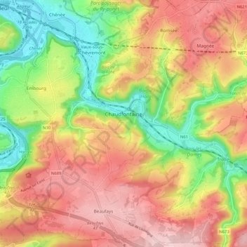
Name: Chaudfontaine topographic map, elevation, terrain.
Location: Chaudfontaine, Liège, Wallonie, 4050, Belgique (50.54959 5.58889 50.61490 5.68029)
Average elevation: 617 ft
Minimum elevation: 203 ft
Maximum elevation: 988 ft
Make a donation
Gear up for your next adventure:
As an Amazon Associate, this site earns from qualifying purchases at no extra cost to you.
Other topographic maps
Click on a map to view its topography, its elevation and its terrain.
Citadelle de Liège
Belgique > Liège > Liège > Liège
La citadelle de Liège est une ancienne citadelle de la ville belge de Liège. Elle était située sur une colline surplombant le Nord de la ville dans le quartier de Sainte-Walburge, à une altitude moyenne de 111 m par rapport à la Meuse et de 170 m par rapport au niveau de la mer.
Average elevation: 381 ft
Bombaye
Bombaye (en wallon Boûbåye, en néerlandais Bolbeek) est une section de la commune belge de Dalhem située en Région wallonne dans la province de Liège. Le village se situe dans l'ouest du Pays de Herve, à une altitude d'environ 125 mètres. Le paysage est caractérisé par des prairies et des vergers.
Average elevation: 377 ft
Make a donation
Gear up for your next adventure:
As an Amazon Associate, this site earns from qualifying purchases at no extra cost to you.
Make a donation
Gear up for your next adventure:
As an Amazon Associate, this site earns from qualifying purchases at no extra cost to you.
Make a donation
Gear up for your next adventure:
As an Amazon Associate, this site earns from qualifying purchases at no extra cost to you.
Make a donation
Gear up for your next adventure:
As an Amazon Associate, this site earns from qualifying purchases at no extra cost to you.
Make a donation
Gear up for your next adventure:
As an Amazon Associate, this site earns from qualifying purchases at no extra cost to you.
Make a donation
Gear up for your next adventure:
As an Amazon Associate, this site earns from qualifying purchases at no extra cost to you.
Make a donation
Gear up for your next adventure:
As an Amazon Associate, this site earns from qualifying purchases at no extra cost to you.
Make a donation
Gear up for your next adventure:
As an Amazon Associate, this site earns from qualifying purchases at no extra cost to you.
Make a donation
Gear up for your next adventure:
As an Amazon Associate, this site earns from qualifying purchases at no extra cost to you.
Make a donation
Gear up for your next adventure:
As an Amazon Associate, this site earns from qualifying purchases at no extra cost to you.
Make a donation
Gear up for your next adventure:
As an Amazon Associate, this site earns from qualifying purchases at no extra cost to you.
Chambralles
Belgique > Liège > Liège > Aywaille
La côte de Chambralles a déjà été gravie lors de la course cycliste Liège-Bastogne-Liège ou lors de l'Eneco Tour ou du Tour de Wallonie. Elle débute au bord de l'Amblève au pont de Martinrive à une altitude de 117 m, traverse les anciennes carrières puis le hameau pour se terminer après 1 600 m à…
Average elevation: 705 ft
Make a donation
Gear up for your next adventure:
As an Amazon Associate, this site earns from qualifying purchases at no extra cost to you.
Make a donation
Gear up for your next adventure:
As an Amazon Associate, this site earns from qualifying purchases at no extra cost to you.
Make a donation
Gear up for your next adventure:
As an Amazon Associate, this site earns from qualifying purchases at no extra cost to you.
Seraing
Belgique > Liège > Liège > Seraing
L'altitude de la commune de Seraing varie entre 59 mètres (au bord de la Meuse, du côté du Val Saint-Lambert) à 273 mètres (à l’est de Boncelles). Il n'est donc pas rare de retrouver plus de neige sur les hauteurs de Seraing en période hivernale.
Average elevation: 459 ft
Flémalle
Belgique > Liège > Liège > Flémalle
La faille marque le relief de la commune, au-dessus des falaises créées par la faille, on a de fortes zones d'urbanisations, comme Les Trixhes, et en dessous également, avec le centre de Flémalle. Cette faille fut longtemps exploitée par différentes carrières. Celles situées derrière le village de…
Average elevation: 499 ft
Make a donation
Gear up for your next adventure:
As an Amazon Associate, this site earns from qualifying purchases at no extra cost to you.
Domaine provincial de Wégimont
Belgique > Liège > Liège > Soumagne > Ayeneux > Basse-Rafhay
Average elevation: 741 ft
Make a donation
Gear up for your next adventure:
As an Amazon Associate, this site earns from qualifying purchases at no extra cost to you.
Make a donation
Gear up for your next adventure:
As an Amazon Associate, this site earns from qualifying purchases at no extra cost to you.
Make a donation
Gear up for your next adventure:
As an Amazon Associate, this site earns from qualifying purchases at no extra cost to you.
Make a donation
Gear up for your next adventure:
As an Amazon Associate, this site earns from qualifying purchases at no extra cost to you.
Val-Benoît
Belgique > Liège > Liège > Liège
Après la Première Guerre mondiale, l'université de Liège, qui depuis sa fondation en 1817 avait établi ses activités dans le centre historique de la ville de Liège, est à la recherche de nouveaux espaces afin de faire face au développement important de l'enseignement des sciences et des techniques. En…
Average elevation: 305 ft
Make a donation
Gear up for your next adventure:
As an Amazon Associate, this site earns from qualifying purchases at no extra cost to you.
Make a donation
Gear up for your next adventure:
As an Amazon Associate, this site earns from qualifying purchases at no extra cost to you.
Make a donation
Gear up for your next adventure:
As an Amazon Associate, this site earns from qualifying purchases at no extra cost to you.
Make a donation
Gear up for your next adventure:
As an Amazon Associate, this site earns from qualifying purchases at no extra cost to you.
Make a donation
Gear up for your next adventure:
As an Amazon Associate, this site earns from qualifying purchases at no extra cost to you.
Make a donation
Gear up for your next adventure:
As an Amazon Associate, this site earns from qualifying purchases at no extra cost to you.