
Make a donation
Gear up for your next adventure:
As an Amazon Associate, this site earns from qualifying purchases at no extra cost to you.
Joly Township topographic map
Click on the map to display elevation.
Make a donation
Gear up for your next adventure:
As an Amazon Associate, this site earns from qualifying purchases at no extra cost to you.
About this map
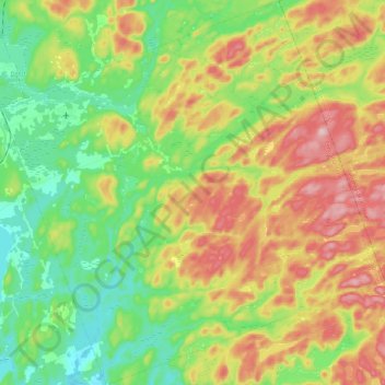
Name: Joly Township topographic map, elevation, terrain.
Average elevation: 1,335 ft
Minimum elevation: 1,056 ft
Maximum elevation: 1,736 ft
Make a donation
Gear up for your next adventure:
As an Amazon Associate, this site earns from qualifying purchases at no extra cost to you.
Other topographic maps
Click on a map to view its topography, its elevation and its terrain.
Moon River
Canada > Ontario > Parry Sound District > The Archipelago Township
Average elevation: 607 ft
Pickerel River
Canada > Ontario > Parry Sound District > Unorganized Centre Parry Sound
Average elevation: 656 ft
Make a donation
Gear up for your next adventure:
As an Amazon Associate, this site earns from qualifying purchases at no extra cost to you.
Dokis Island
Canada > Ontario > Parry Sound District > Unorganized Centre Parry Sound
Average elevation: 643 ft
Port Loring
Canada > Ontario > Parry Sound District > Unorganized Centre Parry Sound
Average elevation: 745 ft
Restoule
Canada > Ontario > Parry Sound District > Unorganized Centre Parry Sound
Average elevation: 778 ft
Pointe au Baril
Canada > Ontario > Parry Sound District > The Archipelago Township
Average elevation: 581 ft
Make a donation
Gear up for your next adventure:
As an Amazon Associate, this site earns from qualifying purchases at no extra cost to you.
Dollars Lake
Canada > Ontario > Parry Sound District > Unorganized Centre Parry Sound
Average elevation: 705 ft
Diamond Lake
Canada > Ontario > Parry Sound District > Seguin Township > Orrville
Average elevation: 896 ft
Make a donation
Gear up for your next adventure:
As an Amazon Associate, this site earns from qualifying purchases at no extra cost to you.
Lake Bernard
Canada > Ontario > Parry Sound District > Strong Township > Sundridge
Average elevation: 1,138 ft
Make a donation
Gear up for your next adventure:
As an Amazon Associate, this site earns from qualifying purchases at no extra cost to you.
Stormy Lake
Canada > Ontario > Parry Sound District > Unorganized Centre Parry Sound
Average elevation: 745 ft
Arnstein
Canada > Ontario > Parry Sound District > Unorganized Centre Parry Sound
Average elevation: 764 ft
Make a donation
Gear up for your next adventure:
As an Amazon Associate, this site earns from qualifying purchases at no extra cost to you.
Ferguson Island
Canada > Ontario > Parry Sound District > Unorganized Centre Parry Sound
Average elevation: 676 ft
Make a donation
Gear up for your next adventure:
As an Amazon Associate, this site earns from qualifying purchases at no extra cost to you.
Manitouwabing Lake
Canada > Ontario > Parry Sound District > McKellar Township > McKellar
Average elevation: 817 ft
Whistler Bay
Canada > Ontario > Parry Sound District > Unorganized Centre Parry Sound
Average elevation: 584 ft
Make a donation
Gear up for your next adventure:
As an Amazon Associate, this site earns from qualifying purchases at no extra cost to you.
Moon River
Canada > Ontario > Parry Sound District > The Archipelago Township
Average elevation: 607 ft
Orrville
Canada > Ontario > Parry Sound District > Seguin Township > Orrville
Average elevation: 860 ft
Make a donation
Gear up for your next adventure:
As an Amazon Associate, this site earns from qualifying purchases at no extra cost to you.
Magnetawan River
Canada > Ontario > Parry Sound District > Unorganized Centre Parry Sound
Average elevation: 650 ft
Make a donation
Gear up for your next adventure:
As an Amazon Associate, this site earns from qualifying purchases at no extra cost to you.
Cole Lake
Canada > Ontario > Parry Sound District > Unorganized Centre Parry Sound
Average elevation: 709 ft
Conger Lake
Canada > Ontario > Parry Sound District > The Archipelago Township
Average elevation: 656 ft
Deer Horn Island
Canada > Ontario > Parry Sound District > The Archipelago Township
Average elevation: 653 ft
Make a donation
Gear up for your next adventure:
As an Amazon Associate, this site earns from qualifying purchases at no extra cost to you.
Richardson Island
Canada > Ontario > Parry Sound District > Nipissing Township
Average elevation: 636 ft
Key River
Canada > Ontario > Parry Sound District > Unorganized Centre Parry Sound
Average elevation: 636 ft
Bosworth Island
Canada > Ontario > Parry Sound District > Unorganized Centre Parry Sound
Average elevation: 735 ft
Doe Lake
Canada > Ontario > Parry Sound District > McMurrich/Monteith Township
Average elevation: 994 ft
Make a donation
Gear up for your next adventure:
As an Amazon Associate, this site earns from qualifying purchases at no extra cost to you.
Culin Lake
Canada > Ontario > Parry Sound District > Unorganized Centre Parry Sound > Arnstein
Average elevation: 755 ft
Make a donation
Gear up for your next adventure:
As an Amazon Associate, this site earns from qualifying purchases at no extra cost to you.
Bob's Lake
Canada > Ontario > Parry Sound District > Unorganized Centre Parry Sound
Average elevation: 837 ft
Make a donation
Gear up for your next adventure:
As an Amazon Associate, this site earns from qualifying purchases at no extra cost to you.
Memesagamesing Lake Dam
Canada > Ontario > Parry Sound District > Unorganized Centre Parry Sound
Average elevation: 745 ft
Make a donation
Gear up for your next adventure:
As an Amazon Associate, this site earns from qualifying purchases at no extra cost to you.
Dollars Lake
Canada > Ontario > Parry Sound District > Unorganized Centre Parry Sound
Average elevation: 705 ft
Jack's Ridge
Canada > Ontario > Parry Sound District > Unorganized Centre Parry Sound
Average elevation: 833 ft
Make a donation
Gear up for your next adventure:
As an Amazon Associate, this site earns from qualifying purchases at no extra cost to you.
Oastler Lake Provincial Park
Canada > Ontario > Parry Sound District > Seguin Township
Average elevation: 715 ft
Make a donation
Gear up for your next adventure:
As an Amazon Associate, this site earns from qualifying purchases at no extra cost to you.
Make a donation
Gear up for your next adventure:
As an Amazon Associate, this site earns from qualifying purchases at no extra cost to you.
Key River
Canada > Ontario > Parry Sound District > Unorganized Centre Parry Sound
Average elevation: 633 ft
Smith Bay
Canada > Ontario > Parry Sound District > Unorganized Centre Parry Sound
Average elevation: 712 ft
Sundridge
Canada > Ontario > Parry Sound District > Strong Township > Sundridge
Average elevation: 1,165 ft
Make a donation
Gear up for your next adventure:
As an Amazon Associate, this site earns from qualifying purchases at no extra cost to you.
Watt Island
Canada > Ontario > Parry Sound District > The Archipelago Township
Average elevation: 640 ft
Nipissing
Canada > Ontario > Parry Sound District > Nipissing Township > Nipissing
Average elevation: 745 ft
Make a donation
Gear up for your next adventure:
As an Amazon Associate, this site earns from qualifying purchases at no extra cost to you.
Recollet Falls
Canada > Ontario > Parry Sound District > Unorganized Centre Parry Sound
Average elevation: 676 ft
Loring
Canada > Ontario > Parry Sound District > Unorganized Centre Parry Sound
Average elevation: 791 ft
Make a donation
Gear up for your next adventure:
As an Amazon Associate, this site earns from qualifying purchases at no extra cost to you.
Magnetawan
Canada > Ontario > Parry Sound District > Magnetawan > Magnetawan
Average elevation: 971 ft
Key Harbour
Canada > Ontario > Parry Sound District > Unorganized Centre Parry Sound
Average elevation: 584 ft
Clear Lake
Canada > Ontario > Parry Sound District > Unorganized Centre Parry Sound
Average elevation: 728 ft
Make a donation
Gear up for your next adventure:
As an Amazon Associate, this site earns from qualifying purchases at no extra cost to you.
Skye Island
Canada > Ontario > Parry Sound District > The Archipelago Township
Average elevation: 627 ft
Magee Island
Canada > Ontario > Parry Sound District > Unorganized Centre Parry Sound
Average elevation: 643 ft
Make a donation
Gear up for your next adventure:
As an Amazon Associate, this site earns from qualifying purchases at no extra cost to you.
Rye
Canada > Ontario > Parry Sound District > Unorganized Centre Parry Sound
Average elevation: 1,129 ft
Sprucedale
Canada > Ontario > Parry Sound District > McMurrich/Monteith Township
Average elevation: 1,083 ft
Jack's Ridge
Canada > Ontario > Parry Sound District > Unorganized Centre Parry Sound
Average elevation: 833 ft
Make a donation
Gear up for your next adventure:
As an Amazon Associate, this site earns from qualifying purchases at no extra cost to you.
Jack's Ridge
Canada > Ontario > Parry Sound District > Unorganized Centre Parry Sound
Average elevation: 833 ft
Make a donation
Gear up for your next adventure:
As an Amazon Associate, this site earns from qualifying purchases at no extra cost to you.