
Make a donation
Gear up for your next adventure:
As an Amazon Associate, this site earns from qualifying purchases at no extra cost to you.
Vratsa topographic map
Click on the map to display elevation.
Make a donation
Gear up for your next adventure:
As an Amazon Associate, this site earns from qualifying purchases at no extra cost to you.
About this map
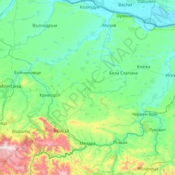
Name: Vratsa topographic map, elevation, terrain.
Location: Vratsa, Bulgaria (42.99391 23.31658 43.80580 24.32427)
Average elevation: 922 ft
Minimum elevation: 72 ft
Maximum elevation: 5,833 ft
Make a donation
Gear up for your next adventure:
As an Amazon Associate, this site earns from qualifying purchases at no extra cost to you.
Other topographic maps
Click on a map to view its topography, its elevation and its terrain.
Make a donation
Gear up for your next adventure:
As an Amazon Associate, this site earns from qualifying purchases at no extra cost to you.
Vitosha
Due to a great variability in elevation, a rich diversity of climates, flora and fauna can be found within the park. Research has revealed that on the comparatively small area of the mountain there are 1,500 species of higher plants, 500 species of fungi, 500 species of algae, 326 species of mosses, and 200…
Average elevation: 6,906 ft
Make a donation
Gear up for your next adventure:
As an Amazon Associate, this site earns from qualifying purchases at no extra cost to you.
Dospat
The town was probably founded by Despot Alexius Slav in the 12th or 13th century, from whose title (despot) its name is very likely derived. Dospat Dam is the highest dam in Bulgaria by altitude and, with its 22 km2 of water area, the second largest in capacity. It is fed by the River Dospat. At the bottom of…
Average elevation: 4,278 ft
Make a donation
Gear up for your next adventure:
As an Amazon Associate, this site earns from qualifying purchases at no extra cost to you.
Make a donation
Gear up for your next adventure:
As an Amazon Associate, this site earns from qualifying purchases at no extra cost to you.
Make a donation
Gear up for your next adventure:
As an Amazon Associate, this site earns from qualifying purchases at no extra cost to you.
Make a donation
Gear up for your next adventure:
As an Amazon Associate, this site earns from qualifying purchases at no extra cost to you.
Make a donation
Gear up for your next adventure:
As an Amazon Associate, this site earns from qualifying purchases at no extra cost to you.
Make a donation
Gear up for your next adventure:
As an Amazon Associate, this site earns from qualifying purchases at no extra cost to you.