
Make a donation
Gear up for your next adventure:
As an Amazon Associate, this site earns from qualifying purchases at no extra cost to you.
Umbertide topographic map
Click on the map to display elevation.
Make a donation
Gear up for your next adventure:
As an Amazon Associate, this site earns from qualifying purchases at no extra cost to you.
About this map
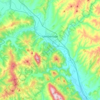
Name: Umbertide topographic map, elevation, terrain.
Location: Umbertide, Perugia, Umbria, 06019, Italia (43.19948 12.16796 43.36269 12.41475)
Average elevation: 1,348 ft
Minimum elevation: 692 ft
Maximum elevation: 3,140 ft
Make a donation
Gear up for your next adventure:
As an Amazon Associate, this site earns from qualifying purchases at no extra cost to you.
Other topographic maps
Click on a map to view its topography, its elevation and its terrain.
Make a donation
Gear up for your next adventure:
As an Amazon Associate, this site earns from qualifying purchases at no extra cost to you.
Make a donation
Gear up for your next adventure:
As an Amazon Associate, this site earns from qualifying purchases at no extra cost to you.
Make a donation
Gear up for your next adventure:
As an Amazon Associate, this site earns from qualifying purchases at no extra cost to you.
Rancolfo
Italia > Umbria > Perugia > Perugia
L'abitato propriamente detto, senza cioè considerare le case sparse presenti in zona, si sviluppa per quasi un chilometro lungo la strada comunale che porta il suo nome (Strada per Rancolfo), a un'altitudine compresa fra i 290 e i 345 m.s.l.m. circa, sul crinale di un sistema collinare che si estende tra il…
Average elevation: 1,079 ft
San Marco
Italia > Umbria > Perugia > Norcia
Il paese si trova ad un'altitudine di 1.125 m s.l.m., su un colle che domina da un lato la piana di Santa Scolastica e, dall'altro, il corso della via Salaria. Secondo i dati del censimento Istat del 2001, i residenti sono 18 (sammarcani).
Average elevation: 3,451 ft
Make a donation
Gear up for your next adventure:
As an Amazon Associate, this site earns from qualifying purchases at no extra cost to you.
Make a donation
Gear up for your next adventure:
As an Amazon Associate, this site earns from qualifying purchases at no extra cost to you.
Montesanto
Italia > Umbria > Perugia > Sellano
Montesanto è una frazione del comune di Sellano, in provincia di Perugia, situata a 8 km dal capoluogo e ad un'altitudine di 743 m s.l.m..
Average elevation: 2,405 ft
Castel San Felice
Italia > Umbria > Perugia > Sant'Anatolia di Narco
L'abitato sorge lungo la strada che collega S. Anatolia (da cui dista 1 km a nord) con Piedipaterno (da cui dista circa 4 km a sud), ad un'altitudine di 334 m s.l.m.. Da Spoleto dista circa 15 km e da Norcia circa 30 km.
Average elevation: 1,827 ft
Make a donation
Gear up for your next adventure:
As an Amazon Associate, this site earns from qualifying purchases at no extra cost to you.
Make a donation
Gear up for your next adventure:
As an Amazon Associate, this site earns from qualifying purchases at no extra cost to you.
Make a donation
Gear up for your next adventure:
As an Amazon Associate, this site earns from qualifying purchases at no extra cost to you.
Make a donation
Gear up for your next adventure:
As an Amazon Associate, this site earns from qualifying purchases at no extra cost to you.
Petrignano
Italia > Umbria > Perugia > Castiglione del Lago
L'abitato si è sviluppato lungo la strada che collega Pozzuolo a Valiano, posta su un crinale che divide il versante della Val di Chiana dal versante della Valle del Trasimeno. Il sistema, in altitudine, oscilla intorno ai 350 metri s.l.m, con punto di apogeo posto in loc. Villa a 378 metri s.l.m.
Average elevation: 991 ft
Make a donation
Gear up for your next adventure:
As an Amazon Associate, this site earns from qualifying purchases at no extra cost to you.
Foligno
Italia > Umbria > Perugia > Foligno > Foligno
Il centro abitato più elevato in altitudine è la frazione di Curasci, che si trova a 1.018 m s.l.m., mentre il più basso è la frazione di Budino, posto a 196 m s.l.m. Da un punto di vista idrografico la maggior parte del territorio comunale è nel bacino del Tevere, quindi sul versante tirrenico della…
Average elevation: 896 ft
Viepri
Italia > Umbria > Perugia > Massa Martana
Viepri è una frazione del comune di Massa Martana (PG), situata a circa 7 km a nord di Massa, 7 km a sud-ovest di Bastardo, ed a 13 km da Todi. Si trova ad un'altitudine di 478 m s.l.m. ed è occupato da 143 abitanti (dati Istat, 2001).
Average elevation: 1,722 ft
Make a donation
Gear up for your next adventure:
As an Amazon Associate, this site earns from qualifying purchases at no extra cost to you.
Make a donation
Gear up for your next adventure:
As an Amazon Associate, this site earns from qualifying purchases at no extra cost to you.
Make a donation
Gear up for your next adventure:
As an Amazon Associate, this site earns from qualifying purchases at no extra cost to you.
Castelluccio
Italia > Umbria > Perugia > Norcia
Il paese si trova sull'Appennino umbro-marchigiano, a circa 28 km da Norcia, ad una altitudine di 1452 m s.l.m. che ne fanno uno dei centri abitati più elevati degli Appennini, posto in cima ad un colle che si eleva sull'omonimo altopiano (Piani di Castelluccio) tra i più vasti dell'Italia Centrale ed…
Average elevation: 4,623 ft
Make a donation
Gear up for your next adventure:
As an Amazon Associate, this site earns from qualifying purchases at no extra cost to you.
Make a donation
Gear up for your next adventure:
As an Amazon Associate, this site earns from qualifying purchases at no extra cost to you.
Make a donation
Gear up for your next adventure:
As an Amazon Associate, this site earns from qualifying purchases at no extra cost to you.
Make a donation
Gear up for your next adventure:
As an Amazon Associate, this site earns from qualifying purchases at no extra cost to you.
Make a donation
Gear up for your next adventure:
As an Amazon Associate, this site earns from qualifying purchases at no extra cost to you.
Leggiana
Italia > Umbria > Perugia > Foligno > Barri
Il centro si trova ad un'altitudine di 546 m s.l.m., a breve distanza dalla Strada statale 77 della Val di Chienti (l'antica via Plestina), che congiunge Foligno a Colfiorito ed alle Marche; adagiato lungo la media valle del Menotre, dista circa 14 km da Foligno e conta 60 abitanti (dati Istat, censimento…
Average elevation: 2,303 ft
Make a donation
Gear up for your next adventure:
As an Amazon Associate, this site earns from qualifying purchases at no extra cost to you.
Make a donation
Gear up for your next adventure:
As an Amazon Associate, this site earns from qualifying purchases at no extra cost to you.
Make a donation
Gear up for your next adventure:
As an Amazon Associate, this site earns from qualifying purchases at no extra cost to you.
Make a donation
Gear up for your next adventure:
As an Amazon Associate, this site earns from qualifying purchases at no extra cost to you.
Make a donation
Gear up for your next adventure:
As an Amazon Associate, this site earns from qualifying purchases at no extra cost to you.
Make a donation
Gear up for your next adventure:
As an Amazon Associate, this site earns from qualifying purchases at no extra cost to you.
Make a donation
Gear up for your next adventure:
As an Amazon Associate, this site earns from qualifying purchases at no extra cost to you.