
West Lakeland topographic map
Interactive map
Click on the map to display elevation.
About this map
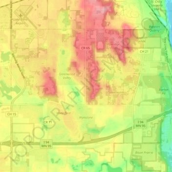
Name: West Lakeland topographic map, elevation, terrain.
Location: West Lakeland, Washington County, Minnesota, United States (44.94881 -92.86284 44.99261 -92.76948)
Average elevation: 902 ft
Minimum elevation: 669 ft
Maximum elevation: 1,093 ft
Other topographic maps
Click on a map to view its topography, its elevation and its terrain.
Stillwater
United States > Minnesota > Washington County
Stillwater, Washington County, Minnesota, United States
Average elevation: 850 ft
Grey Cloud Island
United States > Minnesota > Washington County > Grey Cloud Island Township
Grey Cloud Island, Grey Cloud Island Township, Washington County, Minnesota, 55071, United States
Average elevation: 738 ft
Forest Lake
United States > Minnesota > Washington County
Forest Lake, Washington County, Minnesota, 55025, United States
Average elevation: 915 ft
Saint Paul Park
United States > Minnesota > Washington County
Saint Paul Park, Washington County, Minnesota, 55071, United States
Average elevation: 787 ft
Newport
United States > Minnesota > Washington County
Newport, Washington County, Minnesota, 55055, United States
Average elevation: 817 ft
Afton State Park
United States > Minnesota > Washington County > Afton
Afton State Park, Afton, Denmark Township, Washington County, Minnesota, United States
Average elevation: 850 ft
Cottage Grove
United States > Minnesota > Washington County
Cottage Grove, Washington County, Minnesota, 55016, United States
Average elevation: 817 ft
Lakeland
United States > Minnesota > Washington County
Lakeland, Washington County, Minnesota, 55043, United States
Average elevation: 774 ft
Afton
United States > Minnesota > Washington County
Afton, Washington County, Minnesota, 55001, United States
Average elevation: 850 ft
Mahtomedi
United States > Minnesota > Washington County
Mahtomedi, Washington County, Minnesota, 55115, United States
Average elevation: 984 ft
Scandia
United States > Minnesota > Washington County
Scandia, Washington County, Minnesota, 55073, United States
Average elevation: 932 ft
Oak Park Heights
United States > Minnesota > Washington County
Oak Park Heights, Washington County, Minnesota, United States
Average elevation: 843 ft
Woodbury
United States > Minnesota > Washington County
Woodbury, Washington County, Minnesota, United States
Average elevation: 974 ft
Baytown Township
United States > Minnesota > Washington County
Baytown Township, Washington County, Minnesota, 55082, United States
Average elevation: 915 ft
Pondview Park
United States > Minnesota > Washington County > Woodbury > Oakbury
Pondview Park, Oakbury, Woodbury, Washington County, Minnesota, United States
Average elevation: 1,014 ft
Cottage Grove
United States > Minnesota > Washington County > Cottage Grove > Cottage Grove
Cottage Grove, Washington County, Minnesota, 55016, United States
Average elevation: 850 ft
Scandia
United States > Minnesota > Washington County > Scandia > Scandia
Scandia, Washington County, Minnesota, 55073, United States
Average elevation: 1,010 ft
Hugo
United States > Minnesota > Washington County > Hugo > Hugo
Hugo, Washington County, Minnesota, 55038, United States
Average elevation: 935 ft
Oakdale
United States > Minnesota > Washington County > Oakdale > Oakdale
Oakdale, Washington County, Minnesota, 55128, United States
Average elevation: 994 ft
Afton
United States > Minnesota > Washington County > Afton > Afton
Afton, Washington County, Minnesota, 55001, United States
Average elevation: 804 ft
Hugo
United States > Minnesota > Washington County
Hugo, Washington County, Minnesota, 55038, United States
Average elevation: 932 ft
Lake Elmo
United States > Minnesota > Washington County
Lake Elmo, Washington County, Minnesota, 55042, United States
Average elevation: 942 ft