
Newfoundland and Labrador topographic map
Interactive map
Click on the map to display elevation.
About this map
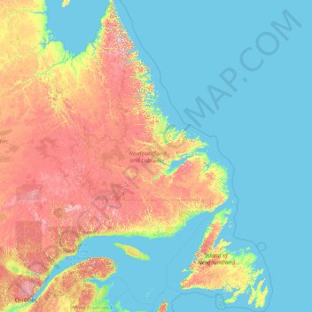
Name: Newfoundland and Labrador topographic map, elevation, terrain.
Location: Newfoundland and Labrador, Canada (46.41019 -67.82169 60.47703 -52.32377)
Average elevation: 630 ft
Minimum elevation: -3 ft
Maximum elevation: 4,488 ft
In 1496, John Cabot obtained a charter from English King Henry VII to "sail to all parts, countries and seas of the East, the West and of the North, under our banner and ensign and to set up our banner on any new-found-land" and on June 24, 1497, landed in Cape Bonavista. Historians disagree on whether Cabot landed in Nova Scotia in 1497 or in Newfoundland, or possibly Maine, if he landed at all, but the governments of Canada and the United Kingdom recognise Bonavista as being Cabot's "official" landing place. In 1499 and 1500, Portuguese mariners João Fernandes Lavrador and Pêro de Barcelos explored and mapped the coast, the former's name appearing as "Labrador" on topographical maps of the period.
Other topographic maps
Click on a map to view its topography, its elevation and its terrain.
Charlottetown
Canada > Prince Edward Island > Queens County
Charlottetown, Queens County, Prince Edward Island, Canada
Average elevation: 62 ft
Halifax
Canada > Nova Scotia > Halifax County
Halifax, Halifax Regional Municipality, Halifax County, Nova Scotia, Canada
Average elevation: 151 ft
Root River
Canada > Northwest Territories
Root River, Northwest Territories, Canada
Average elevation: 2,579 ft
Metro Vancouver Regional District
Metro Vancouver Regional District, British Columbia, Canada
Average elevation: 1,125 ft
Quebec
Canada > Quebec > Urban agglomeration of Québec
Quebec, Urban agglomeration of Québec, Capitale-Nationale, Quebec, Canada
Average elevation: 384 ft
Uxbridge
Canada > Ontario > Durham Region
Uxbridge, Durham Region, Golden Horseshoe, Ontario, Canada
Average elevation: 932 ft
Val-d'Or
Canada > Quebec > La Vallée-de-l'Or
Val-d'Or, La Vallée-de-l'Or, Abitibi-Témiscamingue, Quebec, Canada
Average elevation: 1,086 ft
Fairmont Hot Springs
Canada > British Columbia > Regional District of East Kootenay > Area F (Columbia Lake/Windermere Lake)
Fairmont Hot Springs, Area F (Columbia Lake/Windermere Lake), Regional District of East Kootenay, British Columbia, V0B 1L0, Canada
Average elevation: 3,018 ft
Vancouver Island
Vancouver Island, British Columbia, Canada
Average elevation: 1,348 ft
Area I (Blue Sky Country)
Canada > British Columbia > Thompson-Nicola Regional District
Area I (Blue Sky Country), Thompson-Nicola Regional District, British Columbia, Canada
Average elevation: 4,301 ft
Beach Mountain
Canada > British Columbia > Squamish-Lillooet Regional District > Area C (Pemberton Valley/Mount Currie/D'Arcy)
Beach Mountain, Area C (Pemberton Valley/Mount Currie/D'Arcy), Squamish-Lillooet Regional District, British Columbia, Canada
Average elevation: 6,768 ft
Town of Kensington
Canada > Prince Edward Island > Prince County
Town of Kensington, Prince County, Prince Edward Island, Canada
Average elevation: 118 ft
Calm Lake
Canada > Ontario > Rainy River District > Unorganized Rainy River
Calm Lake, Unorganized Rainy River, Rainy River District, Northwestern Ontario, Ontario, Canada
Average elevation: 1,283 ft
Ruby Creek
Canada > British Columbia > Fraser Valley Regional District > Skawahlook > Ruby Creek
Ruby Creek, Skawahlook, Fraser Valley Regional District, British Columbia, Canada
Average elevation: 554 ft
Gibson Island
Canada > British Columbia > North Coast Regional District > Area C (South Skeena)
Gibson Island, Area C (South Skeena), North Coast Regional District, British Columbia, Canada
Average elevation: 26 ft
The Channel
Canada > Nova Scotia > Yarmouth County > Tusket Islands
The Channel, Tusket Islands, Argyle Municipal District, Yarmouth County, Nova Scotia, Canada
Average elevation: 10 ft
Aberdeen
Canada > Saskatchewan > Division No. 15
Aberdeen, Division No. 15, Saskatchewan, S0K 0A0, Canada
Average elevation: 1,699 ft
Oak Island
Canada > Nova Scotia > Avonport
Oak Island, Avonport, Municipality of the County of Kings, Kings County, Nova Scotia, B0P 1M0, Canada
Average elevation: 272 ft
Tsawwassen First Nation
Canada > British Columbia > Metro Vancouver Regional District
Tsawwassen First Nation, Tsawwassen, Metro Vancouver Regional District, British Columbia, Canada
Average elevation: 16 ft
Brooks
Canada > Alberta > City of Brooks
Brooks, City of Brooks, Alberta, Canada
Average elevation: 2,487 ft
Area D (Lardeau Valley/Duncan Lake)
Canada > British Columbia > Regional District of Central Kootenay
Area D (Lardeau Valley/Duncan Lake), Regional District of Central Kootenay, British Columbia, Canada
Average elevation: 5,446 ft
Nejanilini Lake
Canada > Manitoba > Division No. 23 > Unorganized Division No. 23
Nejanilini Lake, Unorganized Division No. 23, Division No. 23, Manitoba, Canada
Average elevation: 919 ft
Alberton
Canada > Prince Edward Island > Town of Alberton
Alberton, Town of Alberton, Prince County, Prince Edward Island, C0B 1B0, Canada
Average elevation: 23 ft
Balmoral
Canada > Nova Scotia > Municipality of the County of Richmond
Balmoral, Grande Anse, Municipality of the County of Richmond, Richmond County, Nova Scotia, B0E 3K0, Canada
Average elevation: 180 ft
Vancouver
Canada > British Columbia > Metro Vancouver Regional District
Vancouver, Metro Vancouver Regional District, British Columbia, Canada
Average elevation: 112 ft
Tumbler Ridge
Canada > British Columbia > Peace River Regional District
Tumbler Ridge, Peace River Regional District, British Columbia, V0C 2W0, Canada
Average elevation: 3,783 ft
Niagara Falls
Canada > Ontario > Niagara Region
Niagara Falls, Niagara Region, Golden Horseshoe, Ontario, Canada
Average elevation: 587 ft
King Edward Park
Canada > Alberta > Division No. 11 > Edmonton
King Edward Park, Mill Creek South, Edmonton, Division No. 11, Alberta, Canada
Average elevation: 2,201 ft
Cumberland County
Cumberland County, Nova Scotia, Canada
Average elevation: 207 ft
Flat Rock
Canada > Nova Scotia > Municipality of the County of Richmond > Grand River
Flat Rock, Grand River, Municipality of the County of Richmond, Richmond County, Nova Scotia, Canada
Average elevation: 16 ft
Garden River No. 490
Canada > Saskatchewan > Division No. 15
Garden River No. 490, Division No. 15, Saskatchewan, Canada
Average elevation: 1,532 ft
Brigham
Canada > Quebec > Brome-Missisquoi
Brigham, Brome-Missisquoi, Estrie, Quebec, J2K 4V6, Canada
Average elevation: 315 ft
Yellowknife
Canada > Northwest Territories > North Slave Region
Yellowknife, North Slave Region, Northwest Territories, Canada
Average elevation: 607 ft
Nobleton
Canada > Ontario > York Region > King
Nobleton, King, York Region, Golden Horseshoe, Ontario, L0G 1N0, Canada
Average elevation: 866 ft
Summerland
Canada > British Columbia > Regional District of Okanagan-Similkameen
Summerland, Regional District of Okanagan-Similkameen, British Columbia, Canada
Average elevation: 2,283 ft
Mount Sylvia
Canada > British Columbia > Northern Rockies Regional Municipality
Mount Sylvia, Northern Rockies Regional Municipality, British Columbia, Canada
Average elevation: 7,507 ft
York
Canada > Ontario > Haldimand County
York, Haldimand County, Ontario, Canada
Average elevation: 646 ft
The Blue Mountains
Canada > Ontario > Grey County
The Blue Mountains, Grey County, Ontario, N0H 2P0, Canada
Average elevation: 869 ft
Oakland Lake
Canada > Nova Scotia > Digby County
Oakland Lake, Digby Municipal District, Digby County, Nova Scotia, Canada
Average elevation: 509 ft
Cookville
Canada > Nova Scotia > Lunenburg County
Cookville, Municipality of the District of Lunenburg, Lunenburg County, Nova Scotia, Canada
Average elevation: 217 ft
Caribou River
Canada > Nova Scotia > Municipality of Pictou County
Caribou River, Municipality of Pictou County, Pictou County, Nova Scotia, Canada
Average elevation: 39 ft
Town of Mayerthorpe
Canada > Alberta > Division No. 13
Town of Mayerthorpe, Division No. 13, Alberta, T0E 1N0, Canada
Average elevation: 2,333 ft