
Ontario topographic map
Click on the map to display elevation.
Ontario
Ontario's topography is a diverse tapestry shaped by its vast expanse and geological history. The Canadian Shield dominates the northern and central regions, characterized by ancient Precambrian rock formations, rugged terrain, and numerous lakes and rivers. In contrast, the Hudson Bay Lowlands in the far north are flat, swampy areas with sparse vegetation. Southern Ontario features the fertile Great Lakes–St. Lawrence Lowlands, where rolling hills and plains support agriculture and urban development. Prominent features like the Niagara Escarpment add to the province's varied landscape, offering cliffs and slopes that contrast with the surrounding lowlands. The highest elevation point is Ishpatina Ridge in the Temagami area, reaching 693 meters (2,274 feet) above sea level. Overall, Ontario's terrain ranges from flat plains to rolling hills and rugged highlands, reflecting its complex geological past.
About this map
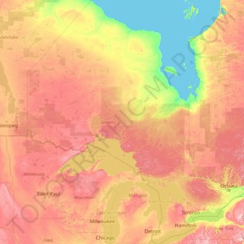
Name: Ontario topographic map, elevation, terrain.
Location: Ontario, Canada (41.67656 -95.15602 56.86135 -74.32011)
Average elevation: 804 ft
Minimum elevation: -7 ft
Maximum elevation: 3,268 ft
Other topographic maps
Click on a map to view its topography, its elevation and its terrain.
Toronto
Despite its deep ravines, Toronto is not remarkably hilly, but its elevation does increase steadily away from the lake. Elevation differences range from 76.5 metres (251 ft) above sea level at the Lake Ontario shore to 209 m (686 ft) ASL near the York University grounds in the city's north end at the…
Average elevation: 371 ft
London
Canada > Ontario > London > London
London has a humid continental climate (Köppen Dfb), though due to its downwind location relative to Lake Huron and elevation changes across the city, it is virtually on the Dfa/Dfb (hot summer) boundary favouring the former climate zone to the southwest of the confluence of the South and North Thames Rivers,…
Average elevation: 879 ft
Banff
Canada > Alberta > Banff > Banff
Banff is a town within Banff National Park in Alberta, Canada. It is located in Alberta's Rockies along the Trans-Canada Highway, approximately 126 km (78 mi) west of Calgary and 58 km (36 mi) east of Lake Louise. At 1,400 to 1,630 m (4,590 to 5,350 ft) above sea level, Banff is the community with the second…
Average elevation: 5,299 ft
70 Mile House
Canada > British Columbia > Thompson-Nicola Regional District > Area E (Bonaparte Plateau)
Average elevation: 3,566 ft
Peterborough
Canada > Ontario > Peterborough
Peterborough's topography is largely defined by land formations created by the receding Wisconsian glaciers 10,000–15,000 years ago. The South End and Downtown portions of the City sit on what was the bottom of the glacial Lake Peterborough—part of a glacial spillway created when glacial meltwaters from…
Average elevation: 771 ft
Upsala
Canada > Ontario > Thunder Bay District > Unorganized Thunder Bay District
Average elevation: 1,598 ft
Vedder River
Canada > British Columbia > Fraser Valley Regional District > Chilliwack
Average elevation: 361 ft
Langley Township
Canada > British Columbia > Metro Vancouver Regional District > Township of Langley > Langley Township
Average elevation: 121 ft
Guelph
This region of Ontario has cold winters and warm, humid summers, falling into the Köppen climate classification Dfb zone, with moderately high rainfall and snowfall. It is generally a couple of degrees cooler than lower elevation regions on the Great Lakes shorelines, especially so in winter, the exception…
Average elevation: 1,129 ft
Ara Lake
Canada > Ontario > Thunder Bay District > Unorganized Thunder Bay District
Average elevation: 1,010 ft
Limerick Lake
Canada > Ontario > Algoma District > Unorganized North Algoma
Average elevation: 1,657 ft
Kamloops
Canada > British Columbia > Thompson-Nicola Regional District > Kamloops
Average elevation: 2,871 ft
Madawaska Highlands
Canada > Ontario > Nipissing District > South Algonquin Township
Average elevation: 1,450 ft
Salmon Arm
Canada > British Columbia > Columbia-Shuswap Regional District > Salmon Arm > Salmon Arm
Average elevation: 1,572 ft
Gaspereau Mountain
Canada > Nova Scotia > Municipality of the County of Kings > Forest Hill
Average elevation: 607 ft
Grouse Mountain
Canada > British Columbia > Metro Vancouver Regional District
Grouse Mountain is one of the North Shore Mountains of the Pacific Ranges in the District Municipality of North Vancouver, British Columbia, Canada. With a maximum elevation of over 1,200 m (4,100 feet) at its peak, the mountain is the site of an alpine ski area, Grouse Mountain Resort, which overlooks Greater…
Average elevation: 3,176 ft
Mount Farnham
Canada > British Columbia > Regional District of East Kootenay > Area G (Forster Creek/Mount Assiniboine)
Average elevation: 9,157 ft
Chute Lake
Canada > British Columbia > Regional District of Okanagan-Similkameen > Area E (Naramata/Greyback)
Average elevation: 4,177 ft
Deroche
Canada > British Columbia > Fraser Valley Regional District > Area G (Deroche/Dewdney/Sumas Mountain)
Average elevation: 377 ft
Aldergrove Regional Park
Canada > British Columbia > Metro Vancouver Regional District > Township of Langley
Average elevation: 210 ft
Burnaby
Canada > British Columbia > Metro Vancouver Regional District > Burnaby
Burnaby occupies 98.60 square kilometres (38.07 sq mi) and is located at the geographic centre of the Metro Vancouver area and home to the Metro Vancouver regional government in Metrotown. Situated between the city of Vancouver on the west and Port Moody, Coquitlam, and New Westminster on the east, Burnaby is…
Average elevation: 472 ft
Crawford Bay
Canada > British Columbia > Regional District of Central Kootenay > Area A (Wynndel/Crawford Bay/Riondel)
Average elevation: 2,188 ft
Tulameen
Canada > British Columbia > Regional District of Okanagan-Similkameen > Area H (Manning Park/Tulameen/Siwash)
Average elevation: 3,028 ft
Fort Steele
Canada > British Columbia > Regional District of East Kootenay > Area C (Moyie/Bull River)
Average elevation: 2,615 ft
Whistler
Canada > British Columbia > Squamish-Lillooet Regional District > Whistler Resort Municipality > Whistler
Average elevation: 3,268 ft
Laurentian Mountains
One of Quebec's official regions is called Laurentides. The mountain range runs through four other regions; Capitale-Nationale, Outaouais, Lanaudière, and Mauricie. The elevation generally ranges from around 500 m (1,640 ft) to 1,000 m (3,280 ft) with Mont Raoul-Blanchard being its highest peak, at 1,166 m…
Average elevation: 1,142 ft
5040 Peak
Canada > British Columbia > Alberni-Clayoquot Regional District > Area D (Sproat Lake)
Average elevation: 3,583 ft
Anahim Lake
Canada > British Columbia > Cariboo Regional District > Area J (West Chilcotin)
Average elevation: 3,612 ft
Surrey
Canada > British Columbia > Metro Vancouver Regional District > Surrey
Average elevation: 213 ft
Port Loring
Canada > Ontario > Parry Sound District > Unorganized Centre Parry Sound
Average elevation: 745 ft
Burditt Lake
Canada > Ontario > Kenora District > Unorganized Kenora District
Average elevation: 1,204 ft
Mount Royal
Canada > Quebec > Urban agglomeration of Montreal > Montreal
The hill is part of the Monteregian Hills situated between the Laurentians and the Appalachian Mountains. It gave its Latin name, Mons Regius, to the Monteregian chain. The hill consists of three peaks: Colline de la Croix (or Mont Royal proper) at 233 m (764 ft), Colline d'Outremont (or Mount Murray, in the…
Average elevation: 364 ft
Grande Prairie
Canada > Alberta > Grande Prairie
Grande Prairie is located just north of the 55th parallel north, and is 465 km (289 mi) northwest of Edmonton, lying at an elevation of 669 m (2,195 ft) above sea level. The city is surrounded by farmland to the north, east, and west. To the south lies a vast boreal forest with aspen, tamarack, lodgepole pine,…
Average elevation: 2,192 ft
Charlie Lake
Canada > British Columbia > Peace River Regional District > Area B (Finlay Valley/Beatton Valley)
Average elevation: 2,497 ft
Trent-Severn Waterway
Canada > Ontario > Peterborough County > North Kawartha > Burleigh Falls
Average elevation: 817 ft
Saint-Pierre de Wakefield
Canada > Quebec > Les Collines-de-l'Outaouais > Val-des-Monts
Average elevation: 735 ft
Avalon Peninsula
Canada > Newfoundland and Labrador > Spaniard's Bay > Tilton
Average elevation: 515 ft