
Make a donation
Gear up for your next adventure:
As an Amazon Associate, this site earns from qualifying purchases at no extra cost to you.
Mangaung Metropolitan Municipality topographic map
Click on the map to display elevation.
Make a donation
Gear up for your next adventure:
As an Amazon Associate, this site earns from qualifying purchases at no extra cost to you.
About this map
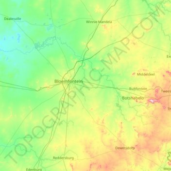
Name: Mangaung Metropolitan Municipality topographic map, elevation, terrain.
Location: Mangaung Metropolitan Municipality, Free State, South Africa (-29.53391 25.71936 -28.76006 27.09448)
Average elevation: 4,596 ft
Minimum elevation: 3,970 ft
Maximum elevation: 6,870 ft
Make a donation
Gear up for your next adventure:
As an Amazon Associate, this site earns from qualifying purchases at no extra cost to you.
Other topographic maps
Click on a map to view its topography, its elevation and its terrain.
Clarens
South Africa > Free State > Thabo Mofutsanyana District Municipality > Dihlabeng Local Municipality
Average elevation: 6,148 ft
Sasolburg
South Africa > Free State > Fezile Dabi District Municipality > Metsimaholo Local Municipality
Sasolburg is at a high altitude with a fairly dry climate and large seasonal temperature variation. It is situated on the banks of the Vaal River, which separates the Free State from the former Transvaal Province, and is not far from the Vaal Dam where excellent windsurfing spots can be found.
Average elevation: 4,820 ft
Bloemfontein
South Africa > Free State > Mangaung Metropolitan Municipality
Situated at an elevation of 1,395 m (4,577 ft) above sea level, the city is home to approximately 520,000 residents and forms part of the Mangaung Metropolitan Municipality which has a population of 747,431. It was one of the host cities for the 2010 FIFA World Cup.
Average elevation: 4,508 ft
Vaal Dam
South Africa > Free State > Fezile Dabi District Municipality > Metsimaholo Local Municipality > Deneysville
Average elevation: 4,859 ft
Make a donation
Gear up for your next adventure:
As an Amazon Associate, this site earns from qualifying purchases at no extra cost to you.
Phuthaditjhaba
South Africa > Free State > Thabo Mofutsanyana District Municipality > Maluti-a-Phofung Local Municipality
Average elevation: 5,696 ft
Bohlokong
South Africa > Free State > Thabo Mofutsanyana District Municipality > Dihlabeng Local Municipality
Average elevation: 5,358 ft
Kroonstad
South Africa > Free State > Fezile Dabi District Municipality > Moqhaka Local Municipality
Average elevation: 4,528 ft
Make a donation
Gear up for your next adventure:
As an Amazon Associate, this site earns from qualifying purchases at no extra cost to you.
Hertzogville
South Africa > Free State > Lejweleputswa District Municipality > Tokologo Local Municipality
Average elevation: 4,216 ft
Bothaville
South Africa > Free State > Lejweleputswa District Municipality > Nala Local Municipality
Average elevation: 4,222 ft
Parys
South Africa > Free State > Fezile Dabi District Municipality > Ngwathe Local Municipality
Average elevation: 4,619 ft
Ficksburg
South Africa > Free State > Thabo Mofutsanyana District Municipality > Setsoto Local Municipality
Average elevation: 5,305 ft
Make a donation
Gear up for your next adventure:
As an Amazon Associate, this site earns from qualifying purchases at no extra cost to you.
Bethlehem
South Africa > Free State > Thabo Mofutsanyana District Municipality > Dihlabeng Local Municipality
The city lies at an altitude of 1,700 metres (5,600 ft) and this contributes to its cool climate with frosty winters and mild summers. The average annual temperature is around 14 °C (57 °F).
Average elevation: 5,495 ft
Welkom
South Africa > Free State > Lejweleputswa District Municipality
Koppie Alleen is the only hill near Welkom and therefore is aptly named for its oddity. The terrain elevation above sea level is 1435 metres. The largest water catchment is the Sand River to the south-east of Welkom in Virginia's direction. Large saline pans such as Flamingo Pan and Theronia Pan are situated…
Average elevation: 4,400 ft
Viljoenskroon
South Africa > Free State > Fezile Dabi District Municipality > Moqhaka Local Municipality
Average elevation: 4,380 ft
Make a donation
Gear up for your next adventure:
As an Amazon Associate, this site earns from qualifying purchases at no extra cost to you.
Vrede
South Africa > Free State > Thabo Mofutsanyana District Municipality > Phumelela Local Municipality
Average elevation: 5,505 ft
Koppies Dam
South Africa > Free State > Fezile Dabi District Municipality > Ngwathe Local Municipality
Average elevation: 4,590 ft
Zastron
South Africa > Free State > Xhariep District Municipality > Mohokare Local Municipality
Average elevation: 5,640 ft
Hoopstad
South Africa > Free State > Lejweleputswa District Municipality > Tswelopele Local Municipality
Average elevation: 4,104 ft
Make a donation
Gear up for your next adventure:
As an Amazon Associate, this site earns from qualifying purchases at no extra cost to you.
Mont Pelaan
South Africa > Free State > Thabo Mofutsanyana District Municipality > Phumelela Local Municipality
Average elevation: 6,430 ft
Hlohlolwane (Clocolan)
South Africa > Free State > Thabo Mofutsanyana District Municipality > Setsoto Local Municipality
Average elevation: 5,226 ft
Bultfontein
South Africa > Free State > Lejweleputswa District Municipality > Tswelopele Local Municipality
Average elevation: 4,350 ft
Deneysville
South Africa > Free State > Fezile Dabi District Municipality > Metsimaholo Local Municipality
Average elevation: 4,908 ft
Make a donation
Gear up for your next adventure:
As an Amazon Associate, this site earns from qualifying purchases at no extra cost to you.
Winnie Mandela (Brandfort)
South Africa > Free State > Lejweleputswa District Municipality > Masilonyana Local Municipality
Average elevation: 4,603 ft
Virginia
South Africa > Free State > Lejweleputswa District Municipality > Matjhabeng Local Municipality
Average elevation: 4,350 ft
Ladybrand
South Africa > Free State > Thabo Mofutsanyana District Municipality > Mantsopa Local Municipality
Average elevation: 5,361 ft
Fouriesburg
South Africa > Free State > Thabo Mofutsanyana District Municipality > Dihlabeng Local Municipality
Average elevation: 5,725 ft
Make a donation
Gear up for your next adventure:
As an Amazon Associate, this site earns from qualifying purchases at no extra cost to you.
Reddersburg
South Africa > Free State > Xhariep District Municipality > Kopanong Local Municipality
Average elevation: 4,669 ft
Renoster River
South Africa > Free State > Thabo Mofutsanyana District Municipality > Nketoana Local Municipality
Average elevation: 5,207 ft
Theunissen
South Africa > Free State > Lejweleputswa District Municipality > Masilonyana Local Municipality
Average elevation: 4,577 ft
Odendaalsrus
South Africa > Free State > Lejweleputswa District Municipality > Matjhabeng Local Municipality
Average elevation: 4,383 ft
Make a donation
Gear up for your next adventure:
As an Amazon Associate, this site earns from qualifying purchases at no extra cost to you.
Reitz
South Africa > Free State > Thabo Mofutsanyana District Municipality > Nketoana Local Municipality
Reitz is located in the north-eastern part of the Free State province, 300 kilometres (190 mi) north-east of Bloemfontein and 180 kilometres (110 mi) south of Johannesburg. It lies roughly halfway between the towns of Bethlehem and Frankfort, at an elevation of 1,630 metres (5,350 ft).
Average elevation: 5,407 ft
Wesselsbron
South Africa > Free State > Lejweleputswa District Municipality > Nala Local Municipality
Average elevation: 4,255 ft
Verkeerdevlei
South Africa > Free State > Lejweleputswa District Municipality > Masilonyana Local Municipality
Average elevation: 4,836 ft
Rouxville
South Africa > Free State > Xhariep District Municipality > Mohokare Local Municipality
Average elevation: 4,980 ft
Make a donation
Gear up for your next adventure:
As an Amazon Associate, this site earns from qualifying purchases at no extra cost to you.
Swartkrans
South Africa > Free State > Thabo Mofutsanyana District Municipality > Dihlabeng Local Municipality
Average elevation: 6,680 ft
Marquard
South Africa > Free State > Thabo Mofutsanyana District Municipality > Setsoto Local Municipality
Average elevation: 4,961 ft
Bloemhof Dam
South Africa > Free State > Lejweleputswa District Municipality > Tswelopele Local Municipality
Average elevation: 4,029 ft
Wilge River
South Africa > Free State > Thabo Mofutsanyana District Municipality > Maluti-a-Phofung Local Municipality
Average elevation: 5,705 ft
Make a donation
Gear up for your next adventure:
As an Amazon Associate, this site earns from qualifying purchases at no extra cost to you.
Koeberg
South Africa > Free State > Thabo Mofutsanyana District Municipality > Dihlabeng Local Municipality
Average elevation: 7,110 ft
Mabula
South Africa > Free State > Thabo Mofutsanyana District Municipality > Mantsopa Local Municipality
Average elevation: 5,794 ft
Smithfield
South Africa > Free State > Xhariep District Municipality > Mohokare Local Municipality
Average elevation: 4,728 ft
Make a donation
Gear up for your next adventure:
As an Amazon Associate, this site earns from qualifying purchases at no extra cost to you.
Tierpoort
South Africa > Free State > Xhariep District Municipality > Kopanong Local Municipality
Average elevation: 4,268 ft
Mount Morkel
South Africa > Free State > Thabo Mofutsanyana District Municipality > Dihlabeng Local Municipality
Average elevation: 6,066 ft
HJ Joel Nature Reserve
South Africa > Free State > Lejweleputswa District Municipality > Masilonyana Local Municipality
Average elevation: 4,547 ft
Fauresmith
South Africa > Free State > Xhariep District Municipality > Kopanong Local Municipality
Average elevation: 4,629 ft
Make a donation
Gear up for your next adventure:
As an Amazon Associate, this site earns from qualifying purchases at no extra cost to you.
Edenville
South Africa > Free State > Fezile Dabi District Municipality > Ngwathe Local Municipality
Average elevation: 4,967 ft
Erfenis Dam
South Africa > Free State > Lejweleputswa District Municipality > Masilonyana Local Municipality
Average elevation: 4,449 ft
Van Stadensrus
South Africa > Free State > Xhariep District Municipality > Naledi Local Municipality
Average elevation: 4,852 ft
Heilbron
South Africa > Free State > Fezile Dabi District Municipality > Ngwathe Local Municipality
Average elevation: 5,115 ft
Make a donation
Gear up for your next adventure:
As an Amazon Associate, this site earns from qualifying purchases at no extra cost to you.
Elands River
South Africa > Free State > Thabo Mofutsanyana District Municipality > Maluti-a-Phofung Local Municipality
Average elevation: 5,374 ft
Rustfontein Dam
South Africa > Free State > Mangaung Metropolitan Municipality
Average elevation: 4,511 ft
Driekloof Dam
South Africa > Free State > Thabo Mofutsanyana District Municipality > Maluti-a-Phofung Local Municipality
Average elevation: 5,719 ft
Parys
South Africa > Free State > Fezile Dabi District Municipality > Ngwathe Local Municipality
Average elevation: 4,619 ft
Make a donation
Gear up for your next adventure:
As an Amazon Associate, this site earns from qualifying purchases at no extra cost to you.
Kroonstad
South Africa > Free State > Fezile Dabi District Municipality > Moqhaka Local Municipality
Average elevation: 4,528 ft
Bronville
South Africa > Free State > Lejweleputswa District Municipality > Matjhabeng Local Municipality
Average elevation: 4,478 ft
Vaal Dam
South Africa > Free State > Fezile Dabi District Municipality > Metsimaholo Local Municipality > Deneysville
Average elevation: 4,859 ft
Sterkfontein Dam
South Africa > Free State > Thabo Mofutsanyana District Municipality > Maluti-a-Phofung Local Municipality
Average elevation: 5,502 ft
Make a donation
Gear up for your next adventure:
As an Amazon Associate, this site earns from qualifying purchases at no extra cost to you.
Vaal Dam
South Africa > Free State > Fezile Dabi District Municipality > Metsimaholo Local Municipality > Deneysville
Average elevation: 4,859 ft
Heilbron
South Africa > Free State > Fezile Dabi District Municipality > Ngwathe Local Municipality
Average elevation: 5,115 ft
Bothaville
South Africa > Free State > Lejweleputswa District Municipality > Nala Local Municipality
Average elevation: 4,222 ft
Renoster River
South Africa > Free State > Thabo Mofutsanyana District Municipality > Nketoana Local Municipality > Petrus Steyn
Average elevation: 5,571 ft
Make a donation
Gear up for your next adventure:
As an Amazon Associate, this site earns from qualifying purchases at no extra cost to you.
Welkom
South Africa > Free State > Lejweleputswa District Municipality
Koppie Alleen is the only hill near Welkom and therefore is aptly named for its oddity. The terrain elevation above sea level is 1435 metres. The largest water catchment is the Sand River to the south-east of Welkom in Virginia's direction. Large saline pans such as Flamingo Pan and Theronia Pan are situated…
Average elevation: 4,400 ft
Bothaville
South Africa > Free State > Lejweleputswa District Municipality > Nala Local Municipality
Average elevation: 4,222 ft
Jacobsdal
South Africa > Free State > Xhariep District Municipality > Letsemeng Local Municipality
Average elevation: 3,763 ft
Sasolburg
South Africa > Free State > Fezile Dabi District Municipality > Metsimaholo Local Municipality
Sasolburg is at a high altitude with a fairly dry climate and large seasonal temperature variation. It is situated on the banks of the Vaal River, which separates the Free State from the former Transvaal Province, and is not far from the Vaal Dam where excellent windsurfing spots can be found.
Average elevation: 4,820 ft
Make a donation
Gear up for your next adventure:
As an Amazon Associate, this site earns from qualifying purchases at no extra cost to you.
Ficksburg
South Africa > Free State > Thabo Mofutsanyana District Municipality > Setsoto Local Municipality
Average elevation: 5,305 ft
Vredefort
South Africa > Free State > Fezile Dabi District Municipality > Ngwathe Local Municipality
Average elevation: 4,692 ft
Bloemfontein
South Africa > Free State > Mangaung Metropolitan Municipality
Situated at an elevation of 1,395 m (4,577 ft) above sea level, the city is home to 256,185 (as of 2011) residents and forms part of the Mangaung Metropolitan Municipality which has a population of 747,431. It was one of the host cities for the 2010 FIFA World Cup.
Average elevation: 4,508 ft
Make a donation
Gear up for your next adventure:
As an Amazon Associate, this site earns from qualifying purchases at no extra cost to you.
Rainfall Dam
South Africa > Free State > Thabo Mofutsanyana District Municipality > Maluti-a-Phofung Local Municipality
Average elevation: 5,600 ft
Welkom
South Africa > Free State > Lejweleputswa District Municipality
Koppie Alleen is the only hill near Welkom and therefore is aptly named for its oddity. The terrain elevation above sea level is 1435 metres. The largest water catchment is the Sand River to the south-east of Welkom in Virginia's direction. Large saline pans such as Flamingo Pan and Theronia Pan are situated…
Average elevation: 4,400 ft
iNtabazwe (Harrismith)
South Africa > Free State > Thabo Mofutsanyana District Municipality > Maluti-a-Phofung Local Municipality
Average elevation: 5,630 ft
Bloemfontein
South Africa > Free State > Mangaung Metropolitan Municipality
Situated at an elevation of 1,395 m (4,577 ft) above sea level, the city is home to 256,185 (as of 2011) residents and forms part of the Mangaung Metropolitan Municipality which has a population of 747,431. It was one of the host cities for the 2010 FIFA World Cup.
Average elevation: 4,508 ft
Make a donation
Gear up for your next adventure:
As an Amazon Associate, this site earns from qualifying purchases at no extra cost to you.
Senekal
South Africa > Free State > Thabo Mofutsanyana District Municipality > Setsoto Local Municipality
Average elevation: 4,760 ft
Welkom
South Africa > Free State > Lejweleputswa District Municipality
Koppie Alleen is the only hill near Welkom and therefore is aptly named for its oddity. The terrain elevation above sea level is 1435 metres. The largest water catchment is the Sand River to the south-east of Welkom in Virginia's direction. Large saline pans such as Flamingo Pan and Theronia Pan are situated…
Average elevation: 4,400 ft
Petrus Steyn
South Africa > Free State > Thabo Mofutsanyana District Municipality > Nketoana Local Municipality
Average elevation: 5,538 ft
Make a donation
Gear up for your next adventure:
As an Amazon Associate, this site earns from qualifying purchases at no extra cost to you.
Bloemfontein
South Africa > Free State > Mangaung Metropolitan Municipality
Situated at an elevation of 1,395 m (4,577 ft) above sea level, the city is home to 256,185 (as of 2011) residents and forms part of the Mangaung Metropolitan Municipality which has a population of 747,431. It was one of the host cities for the 2010 FIFA World Cup.
Average elevation: 4,508 ft
Highveld
South Africa > Free State > Lejweleputswa District Municipality > Matjhabeng Local Municipality
The Highveld (Afrikaans: Hoëveld, pronounced [ˈɦuəfælt], lit. 'High Field') is the portion of the South African inland plateau which has an altitude above roughly 1,500 m (4,900 ft), but below 2,100 m (6,900 ft), thus excluding the Lesotho mountain regions to the south-east of the Highveld. It is home…
Average elevation: 4,528 ft
Viljoenskroon
South Africa > Free State > Fezile Dabi District Municipality > Moqhaka Local Municipality
Average elevation: 4,380 ft
Paardeberg
South Africa > Free State > Xhariep District Municipality > Letsemeng Local Municipality
Average elevation: 3,832 ft
Make a donation
Gear up for your next adventure:
As an Amazon Associate, this site earns from qualifying purchases at no extra cost to you.
Bloemspruit
South Africa > Free State > Mangaung Metropolitan Municipality > Bloemfontein
Average elevation: 4,514 ft
Bethlehem
South Africa > Free State > Thabo Mofutsanyana District Municipality > Dihlabeng Local Municipality
The city lies at an altitude of 1,700 metres (5,600 ft) and this contributes to its cool climate with frosty winters and mild summers. The average annual temperature is around 14 °C (57 °F).
Average elevation: 5,495 ft
Bloemfontein
South Africa > Free State > Mangaung Metropolitan Municipality
Situated at an elevation of 1,395 m (4,577 ft) above sea level, the city is home to 256,185 (as of 2011) residents and forms part of the Mangaung Metropolitan Municipality which has a population of 747,431. It was one of the host cities for the 2010 FIFA World Cup.
Average elevation: 4,508 ft
Dewetsdorp
South Africa > Free State > Xhariep District Municipality > Naledi Local Municipality
Average elevation: 5,138 ft
Make a donation
Gear up for your next adventure:
As an Amazon Associate, this site earns from qualifying purchases at no extra cost to you.
Bloemfontein
South Africa > Free State > Mangaung Metropolitan Municipality
Situated at an elevation of 1,395 m (4,577 ft) above sea level, the city is home to 256,185 (as of 2011) residents and forms part of the Mangaung Metropolitan Municipality which has a population of 747,431. It was one of the host cities for the 2010 FIFA World Cup.
Average elevation: 4,508 ft
Mabula
South Africa > Free State > Thabo Mofutsanyana District Municipality > Mantsopa Local Municipality
Average elevation: 5,794 ft
Gariep Dam
South Africa > Free State > Xhariep District Municipality > Kopanong Local Municipality
Average elevation: 4,154 ft
Allanridge
South Africa > Free State > Lejweleputswa District Municipality > Matjhabeng Local Municipality
Average elevation: 4,301 ft
Make a donation
Gear up for your next adventure:
As an Amazon Associate, this site earns from qualifying purchases at no extra cost to you.
Marquard
South Africa > Free State > Thabo Mofutsanyana District Municipality > Setsoto Local Municipality
Average elevation: 4,961 ft
Koffiefontein
South Africa > Free State > Xhariep District Municipality > Letsemeng Local Municipality
Average elevation: 3,947 ft
Sasolburg
South Africa > Free State > Fezile Dabi District Municipality > Metsimaholo Local Municipality
Sasolburg is at a high altitude with a fairly dry climate and large seasonal temperature variation. It is situated on the banks of the Vaal River, which separates the Free State from the former Transvaal Province, and is not far from the Vaal Dam where excellent windsurfing spots can be found.
Average elevation: 4,820 ft
Bethlehem
South Africa > Free State > Thabo Mofutsanyana District Municipality > Dihlabeng Local Municipality
The city lies at an altitude of 1,700 metres (5,600 ft) and this contributes to its cool climate with frosty winters and mild summers. The average annual temperature is around 14 °C (57 °F).
Average elevation: 5,495 ft
Make a donation
Gear up for your next adventure:
As an Amazon Associate, this site earns from qualifying purchases at no extra cost to you.
Renovaal
South Africa > Free State > Fezile Dabi District Municipality > Moqhaka Local Municipality
Average elevation: 4,281 ft
Hobhouse
South Africa > Free State > Thabo Mofutsanyana District Municipality > Mantsopa Local Municipality
Average elevation: 4,902 ft
Paul Roux
South Africa > Free State > Thabo Mofutsanyana District Municipality > Dihlabeng Local Municipality
Average elevation: 5,184 ft
Highveld
South Africa > Free State > Lejweleputswa District Municipality > Matjhabeng Local Municipality
Average elevation: 4,528 ft
Make a donation
Gear up for your next adventure:
As an Amazon Associate, this site earns from qualifying purchases at no extra cost to you.