
Make a donation
Gear up for your next adventure:
As an Amazon Associate, this site earns from qualifying purchases at no extra cost to you.
Nagarkurnool topographic map
Click on the map to display elevation.
Make a donation
Gear up for your next adventure:
As an Amazon Associate, this site earns from qualifying purchases at no extra cost to you.
Nagarkurnool
Nagarkurnool is located at 18°00′N 79°35′E / 18.0°N 79.58°E / 18.0; 79.58. It has an average elevation of 458 metres (1503 feet).It is settled in the central Deccan Plateau and northern part of Nallamalla Hills made up of granite rocks and hill formations. Most of the region is occupied by Deccan thorn scrub forests and Central Deccan Plateau dry deciduous forests towards the southern region of the district. The region falls under semi arid climate which left the region barren making the cultivation dependent on seasonal rainfall. Krishna river flows from southern border of district and additionally the district has many interlinked chains of lakes and ponds that drain into "Dindubi" river. Located in the semi-arid region of Telangana, Nagarkurnool has a predominantly hot and dry climate. Summer starts in March, and peak in May with average high temperatures in the 42 °C (108 °F) range. The monsoon arrives in June and lasts until September with about 550 mm (22 in) of precipitation. A dry, mild winter starts in October and lasts until early February, when there is little humidity and average temperatures in the 22–23 °C (72–73 °F) range. Many hill rocks and lakes are located throughout district.
Make a donation
Gear up for your next adventure:
As an Amazon Associate, this site earns from qualifying purchases at no extra cost to you.
About this map
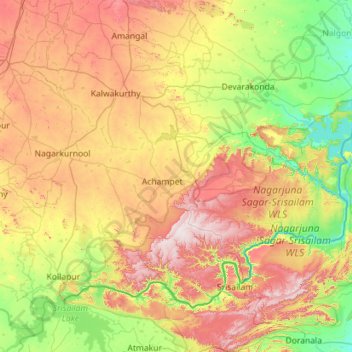
Name: Nagarkurnool topographic map, elevation, terrain.
Location: Nagarkurnool, Telangana, India (16.00053 78.10083 16.83096 79.23426)
Average elevation: 1,375 ft
Minimum elevation: 495 ft
Maximum elevation: 2,913 ft
Make a donation
Gear up for your next adventure:
As an Amazon Associate, this site earns from qualifying purchases at no extra cost to you.
Other topographic maps
Click on a map to view its topography, its elevation and its terrain.
Jadcherla
India > Telangana > Jadcherla mandal
Jadcherla is located at 16°46′26″N 78°08′12″E / 16.7738°N 78.1367°E / 16.7738; 78.1367 and at an altitude of 14 m (46 ft). The town is spread over an area of 550 km2 (210 sq mi). Jadcherla is located 86 km from Hyderabad 130km from Kurnool and 21 km from Mahabubnagar.
Average elevation: 1,811 ft
Make a donation
Gear up for your next adventure:
As an Amazon Associate, this site earns from qualifying purchases at no extra cost to you.
Make a donation
Gear up for your next adventure:
As an Amazon Associate, this site earns from qualifying purchases at no extra cost to you.
Make a donation
Gear up for your next adventure:
As an Amazon Associate, this site earns from qualifying purchases at no extra cost to you.
Jagdevpur
India > Telangana > Jagdevpur mandal
Located at 17°46′05″N 78°48′29″E / 17.768°N 78.808°E / 17.768; 78.808, Jagadevpur has an average elevation of 568 metres (1,864 ft). It is the fourth-largest mandal of the Siddipet district. Jagadevpur is 70 km north of Hyderabad and 30 km each from Bhongir and the famous Yadagirigutta (Temple).
Average elevation: 1,791 ft
Make a donation
Gear up for your next adventure:
As an Amazon Associate, this site earns from qualifying purchases at no extra cost to you.
Make a donation
Gear up for your next adventure:
As an Amazon Associate, this site earns from qualifying purchases at no extra cost to you.
Make a donation
Gear up for your next adventure:
As an Amazon Associate, this site earns from qualifying purchases at no extra cost to you.
Nakrekal
India > Telangana > Nakrekal mandal
Nakrekal is located at 17°09′53″N 79°25′39″E / 17.16469834°N 79.42747827°E / 17.16469834; 79.42747827. It has an average elevation of 240 metres (790 ft).
Average elevation: 679 ft
Make a donation
Gear up for your next adventure:
As an Amazon Associate, this site earns from qualifying purchases at no extra cost to you.
Make a donation
Gear up for your next adventure:
As an Amazon Associate, this site earns from qualifying purchases at no extra cost to you.
Make a donation
Gear up for your next adventure:
As an Amazon Associate, this site earns from qualifying purchases at no extra cost to you.
Gajwel
India > Telangana > Gajwel mandal
The town is located on the Deccan Plateau and is surrounded by agricultural lands. It lies at an average elevation of around 540 meters (1,770 feet) above sea level. The area is characterized by undulating terrain with scattered hills and valleys.
Average elevation: 1,864 ft
Make a donation
Gear up for your next adventure:
As an Amazon Associate, this site earns from qualifying purchases at no extra cost to you.
Kothagudem
India > Telangana > Kothagudem mandal
Kothagudem is located at 17°33′00″N 80°37′05″E / 17.55°N 80.618°E / 17.55; 80.618. It has an average elevation of 89 metres (295 ft) above sea level. The North of Kothagudem borders Chhattisgarh state which is approximately 120 km from the town.
Average elevation: 358 ft
Make a donation
Gear up for your next adventure:
As an Amazon Associate, this site earns from qualifying purchases at no extra cost to you.
Make a donation
Gear up for your next adventure:
As an Amazon Associate, this site earns from qualifying purchases at no extra cost to you.
Make a donation
Gear up for your next adventure:
As an Amazon Associate, this site earns from qualifying purchases at no extra cost to you.
Make a donation
Gear up for your next adventure:
As an Amazon Associate, this site earns from qualifying purchases at no extra cost to you.
Munugode
India > Telangana > Munugode mandal
Munungode is located at 17°04′00″N 79°04′00″E / 17.0667°N 79.0667°E / 17.0667; 79.0667.[2] It has an average elevation of 241 metres (793 ft).
Average elevation: 823 ft