Geolocate

Strait of Hormuz topographic map

Click on the map to display elevation.

About this map

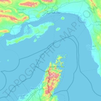
Name: Strait of Hormuz topographic map, elevation, terrain.

Location: Strait of Hormuz, Oman (25.71057 55.21274 27.18876 57.34689)

Average elevation: 246 ft

Minimum elevation: -20 ft

Maximum elevation: 6,696 ft

Other topographic maps

Click on a map to view its topography, its elevation and its terrain.

Musandam

Oman

The rugged coastline resembles the glacier-carved coasts of polar regions, but in this case, the coast was shaped by the movement of Earth's crust. The Arabian Plate is slowly pushing under the Eurasian Plate, creating the earthquake-prone mountains of Iran. On the leading edge of the Arabian Plate, the…

Average elevation: 833 ft

Muscat

Oman > Muscat Governorate

Average elevation: 440 ft

Bahla Fort

Oman > Ad Dakhiliyah Governorate > Bahla Province

Preservation attempt in 1995 was found to be a renovation not a restoration because the aim of the remodeling was to make the fort look new. This renovation began without prior archaeological, topographic, architectural or technical surveys.

Average elevation: 1,886 ft

Jabal Shams

Oman > Ad Dakhiliyah Governorate

The mountain also has a second summit, the South Summit, which is publicly accessible for trekking via the W4 Trail, marked by the Oman Ministry of Tourism. The elevation of the second south summit is 2,997 m (9,833 ft).

Average elevation: 8,041 ft

Dahariz

Oman > Dhofar Governorate > Salalah Province

Average elevation: 13 ft

الجزيرة

Oman > Al Buraimi Governorate

Average elevation: 1,608 ft

Sharaf al Ghaf

Oman > Ad Dhahirah Governorate

Average elevation: 794 ft

Sudh

Oman > Dhofar Governorate > Salalah Province

Average elevation: 62 ft

Tibat

Oman > Musandam Governorate > Bukha Province

Average elevation: 427 ft

Izki

Oman > Ad Dakhiliyah Governorate

Izki (Arabic: إِزْكِي) is a town in the Ad Dakhiliyah region of northeastern Oman. It is located at c. 544 m (1,785 ft) altitude, and has a population of 35,173 (2003 census).

Average elevation: 2,172 ft

Sayh Yalha

Oman > Al Buraimi Governorate

Average elevation: 679 ft

Muscat

Oman > Muscat Governorate

Average elevation: 440 ft

Duqm

Oman > Al Wusta Governorate > Ad Duqm Province

Average elevation: 171 ft

Jebel Jais

Oman > Musandam Governorate > Bukha Province

Jebel Jais (Arabic: جبل جيس, romanized: Jabal Jays) is a mountain of the North-Western Hajar range in the Musandam Governorate of Oman and also in Ras Al Khaimah, United Arab Emirates. The summit has an elevation of 1,934 m (6,345 ft). The summit is located on the Omani side, but a high point west of…

Average elevation: 5,184 ft

As Saiq

Oman > Ad Dakhiliyah Governorate

Saiq has a cold semi-arid climate (Köppen climate classification: BSk), with hot summers and cool winters. Precipitation is higher, and temperatures are lower, than in many other towns in Oman due to its high altitude in the Al Hajar Mountains. The highest temperature recorded in Saiq is 40.4 °C (104.7 °F),…

Average elevation: 6,191 ft

Al Hajar Mountains

Oman > Al Batinah South Governorate

The high topography is around two major culminations: Jabal Akhdar and Saih Hatat, which are large scale anticlines. The Saih Hatat culmination contains eclogite in the northeast at As Sifah. These rocks were subducted to about 80 km (50 mi) depth into the mantle, and then exhumed back to the surface. This…

Average elevation: 8,209 ft

Jurayf

Oman > Ash Sharqiyah South Governorate > Sur Province > Tiwi

Average elevation: 328 ft

Dibba

Oman > Musandam Governorate

Average elevation: 1,115 ft

Jabal Samhan

Oman > Dhofar Governorate

Average elevation: 3,514 ft

Yanqul

Oman > Ad Dhahirah Governorate

Average elevation: 1,985 ft

Barka

Oman > Al Batinah South Governorate

Average elevation: 148 ft

Wadi Darbat

Oman > Dhofar Governorate

Average elevation: 564 ft

Samad ash Shan

Oman > Ad Dakhiliyah Governorate

Average elevation: 1,969 ft

Bidiyah

Oman > Ash Sharqiyah North Governorate

Average elevation: 1,132 ft

Duqm

Oman > Al Wusta Governorate

Average elevation: 171 ft

Bimah

Oman > Al Batinah South Governorate

Average elevation: 3,615 ft

العوينة

Oman > Al Buraymi Governorate

Average elevation: 1,129 ft

Suhaylah

Oman > Al Batinah North Governorate

Average elevation: 1,138 ft

Al Kamil

Oman > Ash Sharqiyah South Governorate

Average elevation: 764 ft

Taqah

Oman > Dhofar Governorate

Average elevation: 131 ft

Al-Musannah

Oman > Al Batinah South Governorate

Average elevation: 92 ft

Suhaylah

Oman > Al Batinah North Governorate

Average elevation: 1,138 ft

Duqm

Oman > Al Wusta Governorate

Average elevation: 171 ft

Wadi Alwa

Oman > Ash Sharqiyah North Governorate > As Sabal

Average elevation: 1,512 ft

Khasab

Oman > Musandam Governorate

Average elevation: 577 ft

Sohar

Oman > Al Batinah North Governorate

Average elevation: 89 ft

Wadi Mahram

Oman > Ad Dakhiliyah Governorate > Ghariyan

Average elevation: 1,811 ft

Jebel Qas Baar

Oman > Dhofar Governorate > Dubah

Average elevation: 1,663 ft

Nuwa

Oman > Al Buraymi Governorate

Average elevation: 1,506 ft

Yiti

Oman > Muscat Governorate

Average elevation: 302 ft

Ras Madrakah

Oman > Al Wusta Governorate

Average elevation: 79 ft

Bahlā

Oman > Ad Dakhiliyah Governorate

Average elevation: 2,198 ft

Al Amerat

Oman > Muscat Governorate

Average elevation: 584 ft

Falaj ash Sham

Oman > Muscat Governorate

Average elevation: 351 ft

Sir

Oman > Ad Dhahirah Governorate

Average elevation: 2,188 ft

Mughrah

Oman > Muscat Governorate

Average elevation: 869 ft

Thumrait

Oman > Dhofar Governorate

Average elevation: 1,575 ft

Najd

Oman > Al Batinah South Governorate

Average elevation: 3,432 ft

Harat al Hawatim

Oman > Ad Dhahirah Governorate

Average elevation: 2,736 ft

Nizwa

Oman > Ad Dakhiliyah Governorate

Average elevation: 2,539 ft

Wadi Al Arbeieen

Oman > Muscat Governorate

Average elevation: 2,776 ft

Murrah

Oman > Muscat Governorate

Average elevation: 75 ft

Al Hayl

Oman > Al Batinah South Governorate

Average elevation: 3,159 ft

Sawadi

Oman > Al Batinah South Governorate

Average elevation: 0 ft

Salmiyah

Oman > Ash Sharqiyah South Governorate

Average elevation: 190 ft

Muqal

Oman > Ash Sharqiyah North Governorate

Average elevation: 2,769 ft

A'Treef

Oman > Al Batinah North Governorate

Average elevation: 30 ft

auqad bayt fadil

Oman > Dhofar Governorate

Average elevation: 16 ft

Masirah

Oman > Ash Sharqiyah South Governorate

Average elevation: 36 ft

Jardamanah

Oman > Ad Dakhiliyah Governorate

Average elevation: 1,972 ft

ThalKut

Oman > Dhofar Governorate

Average elevation: 509 ft

Bu Baqarah

Oman > Al Batinah North Governorate

Average elevation: 7 ft

Duqm

Oman > Al Wusta Governorate

Average elevation: 46 ft

Khadhrawain

Oman > Al Batinah North Governorate

Average elevation: 46 ft

Al Hamriyah

Oman > Muscat Governorate > Muscat

Average elevation: 361 ft

Falaj

Oman > Muscat Governorate > Muscat

Average elevation: 636 ft

Bahlā

Oman > Ad Dakhiliyah Governorate

Average elevation: 2,198 ft

Salalah

Oman > Dhofar Governorate

Average elevation: 459 ft

Jebel Jais

Oman > Musandam Governorate > Bukha Province

Jebel Jais (Arabic: جَبَل جَيْس, romanized: Jabal Jays) is a mountain of the North-Western Hajar range in the Musandam Governorate of Oman and also in Ras Al Khaimah, United Arab Emirates. The summit has an elevation of 1,934 m (6,345 ft). The summit is located on the Omani side, but a high point…

Average elevation: 5,184 ft

Wadi Darbat

Oman > Dhofar Governorate

Average elevation: 564 ft

Wadi al Hilti

Oman > Al Batinah North Governorate > Sohar

Average elevation: 164 ft

Subaykhah

Oman > Al Batinah South Governorate

Average elevation: 1,211 ft

Amal

Oman > Dhofar Governorate

Average elevation: 823 ft

Al Khuwayr North

Oman > Muscat Governorate > Muscat

Average elevation: 39 ft

Azaibah

Oman > Muscat Governorate > Muscat

Average elevation: 49 ft

Al Khitaym

Oman > Ad Dakhiliyah Governorate

Average elevation: 5,046 ft

Saabah

Oman > Ad Dhahirah Governorate

Average elevation: 3,045 ft

Al Khaburah

Oman > Al Batinah North Governorate

Average elevation: 118 ft

Madinat al Ilam

Oman > Muscat Governorate > Muscat

Average elevation: 105 ft

Jahis

Oman > Ash Sharqiyah North Governorate

Average elevation: 981 ft

Al yahmadi

Oman > Ash Sharqiyah North Governorate

Average elevation: 1,073 ft

al Kahil

Oman > Al Wusta Governorate

Average elevation: 26 ft

Majis

Oman > Al Batinah North Governorate

Average elevation: 16 ft

Sanqar

Oman > Al Batinah North Governorate

Average elevation: 13 ft

Al Qashar

Oman > Al Batinah South Governorate

Average elevation: 6,240 ft

Zaab

Oman > Al Batinah North Governorate > Abu Durus

Average elevation: 7 ft

Al Qaryah

Oman > Ad Dakhiliyah Governorate

Average elevation: 2,270 ft

Gear up for your next adventure:

🥾Hiking Shoes - Durable and comfortable shoes for trail hiking
🧭GPS Watch Accessories - Bands and chargers for GPS watches
🧤Tactile Hiking Gloves - Keep hands warm while operating GPS and smartphone screens
🔥Plasma Lighters - Windproof lighters that work in any weather condition
🥘Titanium Cookware - Durable, featherlight pots and pans for backpacking

As an Amazon Associate, this site earns from qualifying purchases at no extra cost to you.