
Fulton County topographic map
Click on the map to display elevation.
About this map
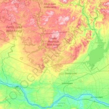
Name: Fulton County topographic map, elevation, terrain.
Location: Fulton County, New York, United States (42.98283 -74.77431 43.28960 -74.09750)
Average elevation: 1,247 ft
Minimum elevation: 226 ft
Maximum elevation: 2,946 ft
New York trails, hiking, mountain biking, running and outdoor activities
Other topographic maps
Click on a map to view its topography, its elevation and its terrain.
Tug Hill
United States > New York > Oswego County
The core Tug Hill region encompasses 150,000 acres (610 km2) of unbroken, generally second-growth, northern hardwood forest, and is drained by a vast network of streams. Important rivers and streams whose headwaters are located within the Tug Hill region include the Mohawk River, Deer River, Salmon River, Mad…
Average elevation: 358 ft
Central Park
United States > New York > New York County > New York
In June 1856, Fernando Wood appointed a "consulting board" of seven people, headed by author Washington Irving, to inspire public confidence in the proposed development. Wood hired military engineer Egbert Ludovicus Viele as the park's chief engineer, tasking him with a topographical survey of the site. The…
Average elevation: 85 ft
Sonyea State Forest
United States > New York > Livingston County > Town of Mount Morris
Average elevation: 758 ft
Riverside Park
United States > New York > New York County > New York
Initially, Riverside Avenue had been planned to run in a straight line, which would have required a retaining wall and extensive fill. However, the area's difficult topography had come to the attention of the Manhattan park commissioners. In 1873, the commissioners selected Frederick Law Olmsted, a park…
Average elevation: 56 ft
South Salem
United States > New York > Westchester County > Town of Lewisboro
Average elevation: 571 ft
Mariandale
United States > New York > Westchester County > Village of Ossining
Average elevation: 174 ft
Central Park
United States > New York > New York County > New York
In June 1856, Fernando Wood appointed a "consulting board" of seven people, headed by author Washington Irving, to inspire public confidence in the proposed development. Wood hired military engineer Egbert Ludovicus Viele as the park's chief engineer, tasking him with a topographical survey of the site. The…
Average elevation: 85 ft
Inwood Hill Park
United States > New York > New York County > New York
Inwood Hill Park is a 196 acres (79 ha) public park in the Inwood neighborhood of Manhattan, New York City, operated by the New York City Department of Parks and Recreation. On a high schist ridge that rises 200 feet (61 m) above the Hudson River from Dyckman Street to the northern tip of the island, Inwood…
Average elevation: 46 ft
Boyntonville
United States > New York > Rensselaer County > Town of Pittstown
Average elevation: 663 ft
Snug Harbor Cultural Center and Botanical Garden
United States > New York > New York
Building C, also known as the Administration Building, was completed in 1833 and is Lafever's oldest surviving work. As of 2020, building C houses part of the Newhouse Center for Contemporary Art. The building consists of two stories, a raised basement, and an attic; it is rectangular in plan with a gable…
Average elevation: 66 ft
Rosedale
United States > New York > Westchester County > City of White Plains
Average elevation: 187 ft
Smithtown Pines
United States > New York > Suffolk County > Town of Smithtown
Average elevation: 95 ft
Whitesville
United States > New York > Allegany County > Town of Independence
Average elevation: 2,005 ft
Potter Hollow
United States > New York > Albany County > Town of Rensselaerville
Average elevation: 1,135 ft
Hartmans Corners
United States > New York > Albany County > Town of Guilderland
Average elevation: 266 ft
Pleasantside
United States > New York > Westchester County > Town of Cortlandt
Average elevation: 354 ft
Brick House Corners
United States > New York > Genesee County > Town of Pembroke
Average elevation: 860 ft
Middle Granville
United States > New York > Washington County > Town of Granville
Average elevation: 512 ft
Balsam Mountain
United States > New York > Ulster County > Town of Shandaken
Average elevation: 2,746 ft
Brooklyn Bridge Park
United States > New York > Kings County > New York
Brooklyn Bridge Park spans 85 acres (34 ha) of the East River waterfront in the Brooklyn Heights and Dumbo neighborhoods of Brooklyn. The park is divided into eleven sections: Piers 1 through 6; Fulton Ferry Landing; Brooklyn Bridge Plaza; Empire Fulton Ferry; Main Street; and John Street. Each of these…
Average elevation: 30 ft
Catamount Mountain
United States > New York > Saint Lawrence County > Town of Colton
Average elevation: 1,421 ft
Oscawana Corners
United States > New York > Putnam County > Town of Putnam Valley
Average elevation: 518 ft
Lake Vanare
United States > New York > Warren County > Town of Lake Luzerne
Average elevation: 1,014 ft
Woodcock Mountain
United States > New York > Saratoga County > Town of Hadley
Average elevation: 889 ft
Constantia Center
United States > New York > Oswego County > Town of Constantia
Average elevation: 554 ft
South New Berlin
United States > New York > Chenango County > Town of New Berlin
Average elevation: 1,247 ft
Coney Island
United States > New York > Saint Lawrence County > Town of Pierrepont
Average elevation: 571 ft
Holiday Valley
United States > New York > Cattaraugus County > Ellicottville
Average elevation: 1,788 ft
South Setauket
United States > New York > Suffolk County > Town of Brookhaven
Average elevation: 144 ft
Henry Johnson Park
United States > New York > Albany County > City of Albany
Average elevation: 167 ft
Sunset Ridge
United States > New York > Westchester County > Town/Village of Harrison
Average elevation: 89 ft