
Town of New Scotland topographic map
Interactive map
Click on the map to display elevation.
About this map
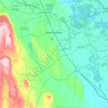
Name: Town of New Scotland topographic map, elevation, terrain.
Location: Town of New Scotland, Albany County, New York, United States (42.53308 -74.02203 42.66967 -73.84714)
Average elevation: 482 ft
Minimum elevation: 95 ft
Maximum elevation: 1,657 ft
Other topographic maps
Click on a map to view its topography, its elevation and its terrain.
City of Albany
United States > New York > Albany County
City of Albany, Albany County, New York, United States
Average elevation: 223 ft
Thompsons Lake
United States > New York > Albany County > Town of Berne
Thompsons Lake, Town of Berne, Albany County, New York, 12059, United States
Average elevation: 1,339 ft
Town of Rensselaerville
United States > New York > Albany County
Town of Rensselaerville, Albany County, New York, United States
Average elevation: 1,355 ft
Town of Coeymans
United States > New York > Albany County
Town of Coeymans, Albany County, New York, United States
Average elevation: 266 ft
Westmere
United States > New York > Albany County > Town of Guilderland
Westmere, Town of Guilderland, Albany County, New York, United States
Average elevation: 259 ft
Village of Altamont
United States > New York > Albany County > Town of Guilderland
Village of Altamont, Town of Guilderland, Albany County, New York, United States
Average elevation: 518 ft
Fort Hunter
United States > New York > Albany County > Town of Guilderland
Fort Hunter, Town of Guilderland, Albany County, New York, 12303, United States
Average elevation: 325 ft
East Berne
United States > New York > Albany County > Town of Berne
East Berne, Town of Berne, Albany County, New York, 12059, United States
Average elevation: 1,345 ft
Cedar Hill
United States > New York > Albany County > Town of Bethlehem
Cedar Hill, Town of Bethlehem, Albany County, New York, 12158, United States
Average elevation: 95 ft
North Bethlehem
United States > New York > Albany County > Town of Guilderland
North Bethlehem, Town of Guilderland, Albany County, New York, 12203, United States
Average elevation: 213 ft
Wemple
United States > New York > Albany County > Town of Bethlehem
Wemple, Town of Bethlehem, Albany County, New York, 12077, United States
Average elevation: 105 ft
West Township
United States > New York > Albany County > Town of Knox
West Township, Town of Knox, Albany County, New York, 12107, United States
Average elevation: 1,273 ft
West Berne
United States > New York > Albany County > Town of Knox
West Berne, Town of Knox, Albany County, New York, 12023, United States
Average elevation: 1,056 ft
Beckers Corners
United States > New York > Albany County > Town of Bethlehem
Beckers Corners, Town of Bethlehem, Albany County, New York, 12158, United States
Average elevation: 161 ft
Bethlehem Heights
United States > New York > Albany County > Town of Bethlehem
Bethlehem Heights, Town of Bethlehem, Albany County, New York, 12161, United States
Average elevation: 174 ft
South Albany
United States > New York > Albany County > Town of Bethlehem
South Albany, Town of Bethlehem, Albany County, New York, 12161, United States
Average elevation: 210 ft
Meadowdale
United States > New York > Albany County > Town of Guilderland
Meadowdale, Town of Guilderland, Albany County, New York, 12085, United States
Average elevation: 377 ft
Wolf Hill
United States > New York > Albany County > Town of New Scotland
Wolf Hill, Town of New Scotland, Albany County, New York, 12041, United States
Average elevation: 1,263 ft
Unionville
United States > New York > Albany County > Town of New Scotland
Unionville, Town of New Scotland, Albany County, New York, 12067, United States
Average elevation: 289 ft
Potter Hollow
United States > New York > Albany County > Town of Rensselaerville
Potter Hollow, Preston-Potter Hollow, Town of Rensselaerville, Albany County, New York, 12469, United States
Average elevation: 1,135 ft
Boght Corners
United States > New York > Albany County > Town of Colonie
Boght Corners, Town of Colonie, Albany County, New York, 12047, United States
Average elevation: 276 ft
Roessleville
United States > New York > Albany County
Roessleville, Town of Colonie, Albany County, New York, 12005, United States
Average elevation: 269 ft
Reidsville
United States > New York > Albany County > Town of Berne
Reidsville, Town of Berne, Albany County, New York, United States
Average elevation: 1,414 ft
South Berne
United States > New York > Albany County > Town of Berne
South Berne, Town of Berne, Albany County, New York, United States
Average elevation: 1,460 ft
Normansville
United States > New York > Albany County > City of Albany
Normansville, City of Albany, Albany County, New York, 12209, United States
Average elevation: 184 ft
Houcks Corners
United States > New York > Albany County > Town of Bethlehem
Houcks Corners, Town of Bethlehem, Albany County, New York, 12054, United States
Average elevation: 194 ft
Spawn Hollow
United States > New York > Albany County > Town of Bethlehem
Spawn Hollow, Town of Bethlehem, Albany County, New York, 12607, United States
Average elevation: 308 ft
Slingerlands
United States > New York > Albany County > Town of Bethlehem
Slingerlands, Town of Bethlehem, Albany County, New York, 12159, United States
Average elevation: 213 ft
South Bethlehem
United States > New York > Albany County > Town of Bethlehem
South Bethlehem, Town of Bethlehem, Albany County, New York, 12161, United States
Average elevation: 236 ft
Coeymans Hollow
United States > New York > Albany County > Town of Coeymans
Coeymans Hollow, Town of Coeymans, Albany County, New York, 12046, United States
Average elevation: 614 ft
Aquetuck
United States > New York > Albany County > Town of Coeymans
Aquetuck, Town of Coeymans, Albany County, New York, 12143, United States
Average elevation: 361 ft
Town of Green Island
United States > New York > Albany County
Town of Green Island, Albany County, New York, 12183, United States
Average elevation: 62 ft
Dunnsville
United States > New York > Albany County > Town of Guilderland
Dunnsville, Town of Guilderland, Albany County, New York, 12009, United States
Average elevation: 427 ft
Fullers
United States > New York > Albany County > Town of Guilderland
Fullers, Town of Guilderland, Albany County, New York, 12085, United States
Average elevation: 295 ft
Hartmans Corners
United States > New York > Albany County > Town of Guilderland
Hartmans Corners, Town of Guilderland, Albany County, New York, 12084, United States
Average elevation: 266 ft
East Township
United States > New York > Albany County > Town of Knox
East Township, Town of Knox, Albany County, New York, 12107, United States
Average elevation: 1,089 ft
Thompson's Lake State Park
United States > New York > Albany County > Town of Knox
Thompson's Lake State Park, Town of Knox, Albany County, New York, United States
Average elevation: 1,345 ft
Clarksville
United States > New York > Albany County > Town of New Scotland
Clarksville, Town of New Scotland, Albany County, New York, 12041, United States
Average elevation: 797 ft
Tarrytown
United States > New York > Albany County > Town of New Scotland
Tarrytown, Town of New Scotland, Albany County, New York, 12041, United States
Average elevation: 728 ft
Cooksburg
United States > New York > Albany County > Town of Rensselaerville
Cooksburg, Preston-Potter Hollow, Town of Rensselaerville, Albany County, New York, 12422, United States
Average elevation: 1,089 ft
Medusa
United States > New York > Albany County > Town of Rensselaerville
Medusa, Town of Rensselaerville, Albany County, New York, 12120, United States
Average elevation: 974 ft
South Westerlo
United States > New York > Albany County > Town of Westerlo
South Westerlo, Town of Westerlo, Albany County, New York, 12083, United States
Average elevation: 955 ft
Lambs Corner
United States > New York > Albany County > Town of Westerlo
Lambs Corner, Town of Westerlo, Albany County, New York, 12083, United States
Average elevation: 1,056 ft
Loudonville
United States > New York > Albany County
Loudonville, Town of Colonie, Albany County, New York, United States
Average elevation: 269 ft
Village of Menands
United States > New York > Albany County > Town of Colonie
Village of Menands, Town of Colonie, Albany County, New York, 12204, United States
Average elevation: 112 ft
Delmar
United States > New York > Albany County > Town of Bethlehem
Delmar, Town of Bethlehem, Albany County, New York, 12054, United States
Average elevation: 200 ft
West Albany
United States > New York > Albany County > City of Albany
West Albany, City of Albany, Albany County, New York, 12111, United States
Average elevation: 256 ft
Town of Knox
United States > New York > Albany County
Town of Knox, Albany County, New York, United States
Average elevation: 1,129 ft
Dunes
United States > New York > Albany County > Westmere
Dunes, Westmere, Town of Guilderland, Albany County, New York, 12203, United States
Average elevation: 246 ft
New Salem
United States > New York > Albany County > Town of New Scotland
New Salem, Town of New Scotland, Albany County, New York, 12186, United States
Average elevation: 696 ft