
Vanderburgh County topographic map
Interactive map
Click on the map to display elevation.
About this map
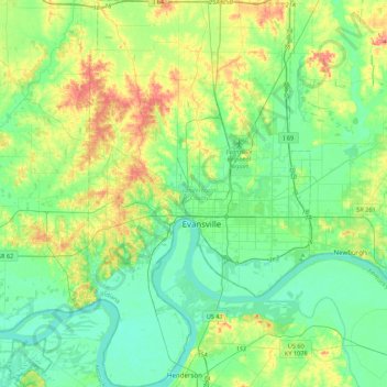
Name: Vanderburgh County topographic map, elevation, terrain.
Location: Vanderburgh County, Indiana, United States (37.82604 -87.70047 38.16842 -87.44941)
Average elevation: 417 ft
Minimum elevation: 335 ft
Maximum elevation: 617 ft
Other topographic maps
Click on a map to view its topography, its elevation and its terrain.
Indianapolis
United States > Indiana > Indianapolis
Indianapolis, Marion County, Indiana, 46204, United States
Average elevation: 791 ft
Fort Wayne
United States > Indiana > Allen County
Fort Wayne, Allen County, Indiana, United States
Average elevation: 807 ft
West Lafayette
United States > Indiana > Tippecanoe County
West Lafayette, Tippecanoe County, Indiana, United States
Average elevation: 630 ft
Bloomington
United States > Indiana > Monroe County
Bloomington, Monroe County, Indiana, United States
Average elevation: 791 ft
North Gate
United States > Indiana > Bartholomew County
North Gate, Bartholomew County, Indiana, 47280, United States
Average elevation: 646 ft
Evansville
United States > Indiana > Vanderburgh County
Evansville, Vanderburgh County, Indiana, United States
Average elevation: 400 ft
South Bend
United States > Indiana > Saint Joseph County
South Bend, Saint Joseph County, Indiana, United States
Average elevation: 774 ft
Lafayette
United States > Indiana > Tippecanoe County
Lafayette, Tippecanoe County, Indiana, United States
Average elevation: 633 ft
Valparaiso
United States > Indiana > Porter County
Valparaiso, Porter County, Indiana, United States
Average elevation: 771 ft
Tippecanoe County
Tippecanoe County, Indiana, United States
Average elevation: 692 ft
Noblesville
United States > Indiana > Hamilton County
Noblesville, Hamilton County, Indiana, 46060, United States
Average elevation: 817 ft
Brekenridge Park
United States > Indiana > Warrick County > Boonville
Brekenridge Park, Boonville, Warrick County, Indiana, United States
Average elevation: 413 ft
Eagle Creek Park
United States > Indiana > Marion County > Indianapolis
Eagle Creek Park, Indianapolis, Marion County, Indiana, 46253, United States
Average elevation: 840 ft
Koontz Lake
United States > Indiana > Starke County
Koontz Lake, Starke County, Indiana, United States
Average elevation: 725 ft
Princeton
United States > Indiana > Gibson County
Princeton, Gibson County, Indiana, 47670, United States
Average elevation: 489 ft
Saint Joseph County
Saint Joseph County, Indiana, United States
Average elevation: 784 ft
Perkins
United States > Indiana > Newton County
Perkins, Newton County, Indiana, United States
Average elevation: 692 ft
Old Pekin
United States > Indiana > Washington County
Old Pekin, Washington County, Indiana, 47165, United States
Average elevation: 751 ft
Nineveh
United States > Indiana > Johnson County
Nineveh, Johnson County, Indiana, United States
Average elevation: 781 ft
Plymouth
United States > Indiana > Marshall County
Plymouth, Marshall County, Indiana, 46563, United States
Average elevation: 810 ft
Portage
United States > Indiana > Porter County
Portage, Porter County, Indiana, United States
Average elevation: 623 ft
Syracuse
United States > Indiana > Kosciusko County
Syracuse, Kosciusko County, Indiana, United States
Average elevation: 876 ft
Bluffton
United States > Indiana > Wells County
Bluffton, Wells County, Indiana, 46714, United States
Average elevation: 833 ft
Rock Hill
United States > Indiana > Spencer County
Rock Hill, Spencer County, Indiana, United States
Average elevation: 407 ft
York
United States > Indiana > Steuben County
York, Steuben County, Indiana, United States
Average elevation: 1,050 ft
Berlien
United States > Indiana > Steuben County
Berlien, Steuben County, Indiana, United States
Average elevation: 1,024 ft
Montpelier
United States > Indiana > Blackford County
Montpelier, Blackford County, Indiana, 47359, United States
Average elevation: 873 ft
Alvarado
United States > Indiana > Steuben County
Alvarado, Steuben County, Indiana, United States
Average elevation: 958 ft
Metz
United States > Indiana > Steuben County
Metz, Steuben County, Indiana, United States
Average elevation: 974 ft
Hamilton County
Hamilton County, Indiana, United States
Average elevation: 856 ft
Spring Grove
United States > Indiana > Wayne County
Spring Grove, Wayne County, Indiana, United States
Average elevation: 984 ft
Union City
United States > Indiana > Randolph County
Union City, Randolph County, Indiana, United States
Average elevation: 1,093 ft
Chain O'Lakes State Park
United States > Indiana > Noble County
Chain O'Lakes State Park, 9, Noble County, Indiana, United States
Average elevation: 951 ft
Shirley
United States > Indiana > Hancock County
Shirley, Hancock County, Indiana, United States
Average elevation: 1,024 ft
Knightstown
United States > Indiana > Henry County
Knightstown, Henry County, Indiana, United States
Average elevation: 935 ft
Switz City
United States > Indiana > Greene County
Switz City, Greene County, Indiana, 47465, United States
Average elevation: 531 ft
Springport
United States > Indiana > Henry County
Springport, Henry County, Indiana, United States
Average elevation: 1,047 ft
Middletown
United States > Indiana > Henry County
Middletown, Henry County, Indiana, United States
Average elevation: 974 ft
Cumberland
United States > Indiana > Hancock County
Cumberland, Hancock County, Indiana, United States
Average elevation: 856 ft
New Palestine
United States > Indiana > Hancock County
New Palestine, Hancock County, Indiana, United States
Average elevation: 830 ft
Mohawk
United States > Indiana > Hancock County
Mohawk, Hancock County, Indiana, United States
Average elevation: 869 ft
Mooreland
United States > Indiana > Henry County
Mooreland, Henry County, Indiana, United States
Average elevation: 1,129 ft
Cadiz
United States > Indiana > Henry County
Cadiz, Henry County, Indiana, United States
Average elevation: 1,073 ft
Depauw
United States > Indiana > Harrison County
Depauw, Harrison County, Indiana, 47115, United States
Average elevation: 738 ft
Sugar Grove
United States > Indiana > Harrison County
Sugar Grove, Harrison County, Indiana, United States
Average elevation: 561 ft