
Make a donation
Gear up for your next adventure:
As an Amazon Associate, this site earns from qualifying purchases at no extra cost to you.
Central Greece topographic map
Click on the map to display elevation.
Make a donation
Gear up for your next adventure:
As an Amazon Associate, this site earns from qualifying purchases at no extra cost to you.
About this map
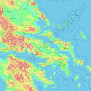
Name: Central Greece topographic map, elevation, terrain.
Location: Central Greece, Thessaly and Central Greece, Greece (37.85238 21.37393 39.27322 24.78599)
Average elevation: 863 ft
Minimum elevation: -16 ft
Maximum elevation: 8,159 ft
Make a donation
Gear up for your next adventure:
As an Amazon Associate, this site earns from qualifying purchases at no extra cost to you.
Other topographic maps
Click on a map to view its topography, its elevation and its terrain.
Athens
Greece > Attica > Regional Unit of Central Athens
Owing to the rain shadow of the Pindus Mountains, annual precipitation of Athens is lower than most other parts of Greece, especially western Greece. As an example, Ioannina receives around 1,300 mm (51 in) per year, and Agrinio around 800 mm (31 in) per year. Daily average highs for July have been measured…
Average elevation: 551 ft
Make a donation
Gear up for your next adventure:
As an Amazon Associate, this site earns from qualifying purchases at no extra cost to you.
Agni Beach
Greece > Ioanian Islands > Corfu Regional Unit > Kassopaia Municipal Unit > Kentroma > Agni
Average elevation: 253 ft
Corfu
Greece > Peloponnese, Western Greece and the Ionian > Corfu Regional Unit
Average elevation: 217 ft
Knossos Palace
Greece > Region of Crete > Heraklion Regional Unit > Heraklion Municipal Unit
The identification of Knossos with the Bronze Age site is supported by the Roman coins that were scattered over the fields surrounding the pre-excavation site, then a large mound named Kephala Hill, elevation 85 m (279 ft) from current sea level. Many of them were inscribed with Knosion or Knos on the obverse…
Average elevation: 495 ft
Πόρτες
Greece > Western Greece > Achaia Regional Unit > Municipal Unit of Olenia
Average elevation: 1,030 ft
Make a donation
Gear up for your next adventure:
As an Amazon Associate, this site earns from qualifying purchases at no extra cost to you.
Κάτω Γύρη-Άγ.Ονούφριος-Ρίζες (Αρκάσας-Μενετών Καρπάθου)
Greece > South Aegean > Karpathos-Kasos Regional Unit > Karpathos Municipal Unit > Menetes
Average elevation: 758 ft
Vasiliki
Greece > Ioanian Islands > Lefkada Regional Unit > Municipal Unit of Apollonioi
Average elevation: 374 ft
Ioannina
Greece > Epirus > Ioannina Regional Unit
Ioannina (Greek: Ιωάννινα Ioánnina [i.oˈa.ni.na] (listen)), often called Yannena (Γιάννενα Yánnena [ˈʝa.ne.na]) within Greece, is the capital and largest city of the Ioannina regional unit and of Epirus, an administrative region in north-western Greece. According to the 2011 census, the…
Average elevation: 2,375 ft
Agios Konstantinos
Greece > Northern Aegean > Samos Regional Unit > Municipal Unit of Vathy
Average elevation: 443 ft
Make a donation
Gear up for your next adventure:
As an Amazon Associate, this site earns from qualifying purchases at no extra cost to you.
Nikiti
Greece > Central Macedonia > Chalkidiki Regional Unit > Sithonia Municipal Unit
Average elevation: 210 ft
Make a donation
Gear up for your next adventure:
As an Amazon Associate, this site earns from qualifying purchases at no extra cost to you.
Koroni
Greece > Peloponnese, Western Greece and the Ionian > Messenia Regional Unit > Koroni Municipal Unit
Between 1966 and 1989 a facility for launching sounding rockets was established near the town. The first launches were performed from Koroni on May 20, 1966 for investigation an annular solar eclipse. These rockets reached an altitude of 114 kilometers. From 1972 to 1989 several Russian meteorological rockets…
Average elevation: 89 ft
Κισσάριο
Greece > Eastern Macedonia and Thrace > Evros Regional Unit > Λάβαρα
Average elevation: 197 ft
Athens
Greece > Attica > Regional Unit of Central Athens
Owing to the rain shadow of the Pindus Mountains, annual precipitation of Athens is lower than most other parts of Greece, especially western Greece. As an example, Ioannina receives around 1,300 mm (51 in) per year, and Agrinio around 800 mm (31 in) per year. Daily average highs for July have been measured…
Average elevation: 551 ft
Make a donation
Gear up for your next adventure:
As an Amazon Associate, this site earns from qualifying purchases at no extra cost to you.
Ρίζα
Greece > Region of Crete > Lasithi Regional Unit > Ierapetra Municipal Unit
Average elevation: 1,814 ft
Make a donation
Gear up for your next adventure:
As an Amazon Associate, this site earns from qualifying purchases at no extra cost to you.
Thebes
Greece > Central Greece > Regional Unit of Boeotia > Municipal Unit of Thebes
Thebes is situated in a plain, between Lake Yliki (ancient Hylica) to the north, and the Cithaeron mountains, which divide Boeotia from Attica, to the south. Its elevation is 215 m (705 ft) above mean sea level. It is about 50 km (31 mi) northwest of Athens, and 100 km (62 mi) southeast of Lamia. The A1…
Average elevation: 715 ft
Pinios
Greece > Western Greece > Elis Regional Unit > Municipality of Pyrgos > Σιτοχώρι
Average elevation: 1,352 ft
Patras
Greece > Peloponnese, Western Greece and the Ionian > Achaia Regional Unit
A central feature of the urban geography of Patras is its division into upper and lower sections. This is the result of an interplay between natural geography and human settlement patterns; the lower section of the city (Kato Poli), which includes the 19th-century urban core and the port, is adjacent to the…
Average elevation: 928 ft
Make a donation
Gear up for your next adventure:
As an Amazon Associate, this site earns from qualifying purchases at no extra cost to you.
Karpenisi
Greece > Central Greece > Regional Unit of Evrytania > Municipal Unit of Karpenisi
Karpenisi (Greek: Καρπενήσι, Greek pronunciation: [karpeˈnisi]) is a town in central Greece. It is the capital of the regional unit of Evrytania. Karpenisi lies within the valley of the river Karpenisiotis (Καρπενησιώτης), a tributary of the Megdovas, in the southern part of the Pindus…
Average elevation: 4,055 ft
Αγία Παρασκευή
Greece > Central Macedonia > Chalkidiki Regional Unit > Pallini Municipal Unit
Average elevation: 541 ft
Sisi
Greece > Region of Crete > Lasithi Regional Unit > Vrachasi Municipal Unit
Average elevation: 190 ft
Make a donation
Gear up for your next adventure:
As an Amazon Associate, this site earns from qualifying purchases at no extra cost to you.
Drimea
Greece > Central Greece > Phthiotis Regional Unit > Municipal Unit of Amfiklia
Average elevation: 1,929 ft
Make a donation
Gear up for your next adventure:
As an Amazon Associate, this site earns from qualifying purchases at no extra cost to you.
Meteora
Greece > Thessaly > Trikala Regional Unit > Kastraki
The Monastery of Rousanou is believed to have been constructed, like many of the other monasteries, in the 14th century. The cathedral is believed to have been built in the 16th century and later decorated in 1540. The name Rousanou is believed to come from the first group of monks who settled on the rock from…
Average elevation: 1,407 ft
Ermioni
Greece > Peloponnese, Western Greece and the Ionian > Argolis Regional Unit > Municipal Unit of Ermioni
Average elevation: 180 ft
Stemnitsa
Greece > Peloponnese, Western Greece and the Ionian > Arcadia Regional Unit > Municipal Unit of Trikolonoi
Stemnitsa (Greek: Στεμνίτσα) is a mountain village in the municipal unit of Trikolonoi, Arcadia, Peloponnese, Greece. It was the seat of the former municipality Trikolonoi. Stemnitsa is a traditional settlement and is considered one of the most beautiful villages in Arcadia, due to its picturesque…
Average elevation: 3,825 ft
Make a donation
Gear up for your next adventure:
As an Amazon Associate, this site earns from qualifying purchases at no extra cost to you.
Karpenisi
Greece > Central Greece > Regional Unit of Evrytania > Municipal Unit of Karpenisi
Karpenisi (Greek: Καρπενήσι, Greek pronunciation: [karpeˈnisi]) is a town in central Greece. It is the capital of the regional unit of Evrytania. Karpenisi lies within the valley of the river Karpenisiotis (Καρπενησιώτης), a tributary of the Megdovas, in the southern part of the Pindus…
Average elevation: 4,055 ft
Argos
Greece > Peloponnese, Western Greece and the Ionian > Argolis Regional Unit
Average elevation: 1,056 ft
Make a donation
Gear up for your next adventure:
As an Amazon Associate, this site earns from qualifying purchases at no extra cost to you.
Pylos
Greece > Peloponnese Region > Messenia Regional Unit
The erection of this fort led to one of the most memorable events in the Peloponnesian War. Thucydides has given a minute account of the topography of the district, which, though clear and consistent with itself, does not coincide, in all points, with the existing locality, Thucydides describes the harbour, of…
Average elevation: 259 ft
Archanes
Greece > Region of Crete > Heraklion Regional Unit > Archanes Municipal Unit
Average elevation: 1,093 ft
Πρόδρομος
Greece > Thessaly and Central Greece > Regional Unit of Boeotia > Δημοτική Ενότητα Θίσβης
Average elevation: 1,207 ft
Make a donation
Gear up for your next adventure:
As an Amazon Associate, this site earns from qualifying purchases at no extra cost to you.
Athens
Greece > Attica > Regional Unit of Central Athens
The southern section of the Athens metropolitan area (i.e., Elliniko, Athens Riviera) lies in the transitional zone between Mediterranean (Csa) and hot semi-arid climate (BSh), with its port-city of Piraeus being the most extreme example, receiving just 331.9 millimetres (13.07 in) per year. The areas to the…
Average elevation: 551 ft
Artemida
Greece > Attica > Regional Unit of East Attica > Artemida Municipal Unit
Average elevation: 125 ft
Make a donation
Gear up for your next adventure:
As an Amazon Associate, this site earns from qualifying purchases at no extra cost to you.
Derveni
Greece > Macedonia and Thrace > Thessaloniki Regional Unit > Mygdonia Municipal Unit > Λητή
Average elevation: 768 ft
Neos Marmaras
Greece > Macedonia and Thrace > Chalkidiki Regional Unit > Sithonia Municipal Unit
Average elevation: 292 ft
Tolo
Greece > Peloponnese Region > Argolis Regional Unit > Municipal Unit of Asini
Average elevation: 144 ft
Make a donation
Gear up for your next adventure:
As an Amazon Associate, this site earns from qualifying purchases at no extra cost to you.
Epitalio
Greece > Western Greece > Elis Regional Unit > Municipality of Pyrgos
Average elevation: 79 ft
Ξηροκάμπι
Greece > Peloponnese, Western Greece and the Ionian > Arcadia Regional Unit
Average elevation: 3,028 ft
Make a donation
Gear up for your next adventure:
As an Amazon Associate, this site earns from qualifying purchases at no extra cost to you.
Chania
Greece > Region of Crete > Chania Regional Unit
The climate in Chania is further complemented due to the terrain and can vary throughout its regions and elevations and according to its topography. At the south lies the mountain range of Lefka Ori. Furthermore, prevailing winds, such as those of the West side and South of Crete, in addition to the North…
Average elevation: 636 ft
Make a donation
Gear up for your next adventure:
As an Amazon Associate, this site earns from qualifying purchases at no extra cost to you.
Vrachasi
Greece > Region of Crete > Lasithi Regional Unit > Vrachasi Municipal Unit
Average elevation: 1,191 ft
Vikos–Aoos National Park
Greece > Epirus > Ioannina Regional Unit
The Vikos–Aoös National Park (Greek: Εθνικός Δρυμός Βίκου–Αώου, romanized: Ethnikós Drymós Víkou–Aóou) is a national park in the region of Epirus in northwestern Greece. The park, founded in 1973, is one of ten national parks in mainland Greece and is located 30 kilometres (19…
Average elevation: 3,763 ft
Make a donation
Gear up for your next adventure:
As an Amazon Associate, this site earns from qualifying purchases at no extra cost to you.
Imera
Greece > Epirus and Western Macedonia > Kozani Regional Unit > Servia Municipal Unit
Average elevation: 1,371 ft
Palaio Faliro
Greece > Attica > Regional Unit of South Athens
Phaleron was an important place in antiquity, then as now one of the demes of Athens; however, a precise definition of its Classical topography is lacking, although the location of the deme is well established. Pausanias records that it was on the coast, equidistant from Athens and Cape Kolias (i.e., Ayios…
Average elevation: 89 ft
Make a donation
Gear up for your next adventure:
As an Amazon Associate, this site earns from qualifying purchases at no extra cost to you.
Taygeti
Greece > Peloponnese Region > Laconia Regional Unit > Municipal Unit of Mystras
Average elevation: 2,644 ft
Serres
Greece > Macedonia and Thrace > Serres Regional Unit
Serres is one of the administrative and economic centers of Northern Greece. The city is situated in a fertile plain at an elevation of about 70 metres (230 feet), some 24 kilometres (15 miles) northeast of the Strymon river and 69 km (43 mi) north-east of Thessaloniki, respectively. Serres' official municipal…
Average elevation: 1,040 ft
Komotini
Greece > Eastern Macedonia and Thrace > Rodopi Regional Unit
The city stands at an altitude of 32-38m on the Thracian plain near the foothills of the Rhodope Mountains. It is situated between two rivers, Boklutzas on the west and Trelohimaros on the east (which form, alongside the Karidia stream, the river Bosbozis). There is little urban planning in the older parts of…
Average elevation: 758 ft
Make a donation
Gear up for your next adventure:
As an Amazon Associate, this site earns from qualifying purchases at no extra cost to you.
Hymettus
Greece > Attica > Regional Unit of Central Athens
The highest point of the mountain range is Evzonas (Εύζωνας) with an elevation of 1,026 m (3,366 ft). The 16 km (9.9 mi) length of Hymettus stretches from Athens to the Saronic Gulf. It is 6 to 7 km from east to west. In ancient times, the highest point was known as Megas Hymettos and the southern peaks…
Average elevation: 2,231 ft
Mátala
Greece > Region of Crete > Heraklion Regional Unit > Tybakio Municipal Unit
Average elevation: 184 ft
Eretria
Greece > Central Greece > Euboea Regional Unit > Eretria Municipal Unit
Average elevation: 148 ft
Make a donation
Gear up for your next adventure:
As an Amazon Associate, this site earns from qualifying purchases at no extra cost to you.
Magouliana
Greece > Peloponnese Region > Arcadia Regional Unit > Municipal Unit of Vytina
Average elevation: 3,858 ft
Leontio
Greece > Peloponnese Region > Corinthia Regional Unit > Municipality of Nemea
Average elevation: 1,496 ft
Eleusis
Greece > Attica > Regional Unit of West Attica > Municipal Unit of Elefsina
Average elevation: 98 ft
Make a donation
Gear up for your next adventure:
As an Amazon Associate, this site earns from qualifying purchases at no extra cost to you.
Kalamaki Beach
Greece > Peloponnese, Western Greece and the Ionian > Zakynthos Regional Unit > Laganas Municipal Unit
Average elevation: 105 ft
Charakas
Greece > Region of Crete > Heraklion Regional Unit > Asterousia Municipal Unit
The community of Charakas (Δημοτική Κοινότητα Χάρακος) consists of the village Charakas and the smaller villages Agia Fotia (Αγιά Φωτιά) (pop. 22, at elevation 275 m, 2 km to the West from Charakas) and Doraki (Δωράκι) (pop. 24, at elevation 310 m, 1.5 km to the East from Charakas).
Average elevation: 1,171 ft
Make a donation
Gear up for your next adventure:
As an Amazon Associate, this site earns from qualifying purchases at no extra cost to you.
Naoussa
Greece > Macedonia and Thrace > Imathia Regional Unit
Naousa is located in Northwestern Imathia, 22 kilometers north of Veria and 90 kilometers west of Thessaloniki. The city lies on the eastern foothills of Vermio Mountains, one of the biggest mountain ranges in Greece, and west to the plain of Giannitsa. Naousa is today the largest forest-owning municipality in…
Average elevation: 2,139 ft
Corinth
Greece > Peloponnese, Western Greece and the Ionian > Corinthia Regional Unit
Average elevation: 69 ft
Make a donation
Gear up for your next adventure:
As an Amazon Associate, this site earns from qualifying purchases at no extra cost to you.
Serres
Greece > Central Macedonia > Serres Regional Unit
Serres is one of the administrative and economic centers of Northern Greece. The city is situated in a fertile plain at an elevation of about 70 metres (230 feet), some 24 kilometres (15 miles) northeast of the Strymon river and 69 km (43 mi) north-east of Thessaloniki, respectively. Serres' official municipal…
Average elevation: 1,040 ft
Make a donation
Gear up for your next adventure:
As an Amazon Associate, this site earns from qualifying purchases at no extra cost to you.
Karterados
Greece > South Aegean > Thira Regional Unit > Thira Municipal Unit
Average elevation: 325 ft
Toroni
Greece > Central Macedonia > Chalkidiki Regional Unit > Toroni Municipal Unit
Average elevation: 157 ft
Roda
Greece > Peloponnese, Western Greece and the Ionian > Corfu Regional Unit
Average elevation: 82 ft
Make a donation
Gear up for your next adventure:
As an Amazon Associate, this site earns from qualifying purchases at no extra cost to you.