
Pike County topographic map
Click on the map to display elevation.
Pike County
The terrain rises rapidly from the river valley in the east to the rolling foothills of the Poconos in the west. The highest point is one of two unnamed hills in Greene Township that top out at approximately 2,110 feet (643 m) above sea level. The lowest elevation is approximately 340 feet (103.6 m), at the confluence of the Bushkill and the Delaware rivers.
About this map
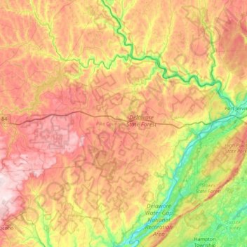
Name: Pike County topographic map, elevation, terrain.
Location: Pike County, Pennsylvania, United States (41.08135 -75.35900 41.60195 -74.68967)
Average elevation: 1,184 ft
Minimum elevation: 318 ft
Maximum elevation: 2,182 ft
Pennsylvania trails, hiking, mountain biking, running and outdoor activities
Other topographic maps
Click on a map to view its topography, its elevation and its terrain.
East Texas
United States > Pennsylvania > Lehigh County > Lower Macungie Township
Average elevation: 413 ft
Havertown
United States > Pennsylvania > Delaware County > Haverford Township
Average elevation: 276 ft
Blakeslee
United States > Pennsylvania > Monroe County > Tobyhanna Township
Average elevation: 1,654 ft
Nottingham
United States > Pennsylvania > Chester County > West Nottingham Township
Average elevation: 476 ft
Limerick
United States > Pennsylvania > Montgomery County > Limerick Township
Average elevation: 282 ft
Albrightsville
United States > Pennsylvania > Carbon County > Kidder Township
Average elevation: 1,634 ft
Shavertown
United States > Pennsylvania > Luzerne County > Kingston Township
Average elevation: 1,158 ft
Dingmans Ferry
United States > Pennsylvania > Pike County > Delaware Township
Average elevation: 630 ft
Normalville
United States > Pennsylvania > Fayette County > Springfield Township
Average elevation: 1,594 ft
Intercourse
United States > Pennsylvania > Lancaster County > Leacock Township
Average elevation: 417 ft
Gilbert
United States > Pennsylvania > Monroe County > Chestnuthill Township
Average elevation: 794 ft
Lake Carey
United States > Pennsylvania > Wyoming County > Lemon Township > Lemon > Lake Carey
Average elevation: 1,060 ft
Wimmers
United States > Pennsylvania > Lackawanna County > Jefferson Township > Mount Cobb
Average elevation: 1,624 ft
Teepleville
United States > Pennsylvania > Crawford County > Richmond Township
Average elevation: 1,266 ft
Mainesburg
United States > Pennsylvania > Tioga County > Sullivan Township
Average elevation: 1,565 ft
Mount Nebo Park
United States > Pennsylvania > Monroe County > East Stroudsburg > Twin Falls
Average elevation: 607 ft
Russell
United States > Pennsylvania > Warren County > Pine Grove Township
Average elevation: 1,450 ft
Pricetown
United States > Pennsylvania > Berks County > Ruscombmanor Township
Average elevation: 784 ft
Cornwells Heights
United States > Pennsylvania > Bucks County > Bensalem Township
Average elevation: 52 ft
Cowden
United States > Pennsylvania > Washington County > Cecil Township > Cecil
Average elevation: 1,135 ft
Idaho
United States > Pennsylvania > Armstrong County > South Bend Township
Average elevation: 1,112 ft
Keown Station
United States > Pennsylvania > Allegheny County > Ross Township
Average elevation: 1,129 ft
Glenshaw
United States > Pennsylvania > Allegheny County > Shaler Township
Average elevation: 1,024 ft
Stony Creek Mills
United States > Pennsylvania > Berks County > Lower Alsace Township > Pennside
Average elevation: 630 ft
New Enterprise
United States > Pennsylvania > Bedford County > South Woodbury Township
Average elevation: 1,302 ft
Blue Knob
United States > Pennsylvania > Bedford County > Pavia Township
Blue Knob (elevation 3,146 feet (959 m)) is a summit in the eastern United States with a broad dome that is the northernmost 3,000-footer in the Allegheny Mountains. It is the highest point in Bedford County, Pennsylvania.
Average elevation: 2,598 ft
Sinnemahoning
United States > Pennsylvania > Cameron County > Gibson Township
Average elevation: 1,332 ft
Saint Benedict
United States > Pennsylvania > Cambria County > West Carroll Township
Average elevation: 1,909 ft
English Center
United States > Pennsylvania > Lycoming County > Pine Township
Average elevation: 1,457 ft
Tyrrel Farm Corners
United States > Pennsylvania > Venango County > Allegheny Township
Average elevation: 1,568 ft
Orvilla
United States > Pennsylvania > Montgomery County > Hatfield Township
Average elevation: 328 ft
Fort Hunter
United States > Pennsylvania > Dauphin County > Middle Paxton Township
Average elevation: 489 ft
Fisherville
United States > Pennsylvania > Dauphin County > Jackson Township
Average elevation: 604 ft
Spring Run
United States > Pennsylvania > Franklin County > Fannett Township
Average elevation: 955 ft
Old Forge
United States > Pennsylvania > Franklin County > Quincy Township
Average elevation: 1,273 ft
Green Village
United States > Pennsylvania > Franklin County > Greene Township
Average elevation: 679 ft
Chalkhill
United States > Pennsylvania > Fayette County > Wharton Township
Average elevation: 2,044 ft
Arnold City
United States > Pennsylvania > Fayette County > Washington Township
Average elevation: 994 ft
Three Tuns
United States > Pennsylvania > Montgomery County > Upper Dublin Township > Maple Glen
Average elevation: 331 ft
Hidden Valley
United States > Pennsylvania > Montgomery County > Upper Merion Township
Average elevation: 154 ft
Newfoundland
United States > Pennsylvania > Wayne County > Dreher Township
Average elevation: 1,496 ft
Strafford
United States > Pennsylvania > Chester County > Tredyffrin Township
Average elevation: 436 ft
West Pittsburg
United States > Pennsylvania > Lawrence County > Taylor Township
Average elevation: 915 ft
Dilltown
United States > Pennsylvania > Indiana County > East Wheatfield Township
Average elevation: 1,555 ft
Robinson
United States > Pennsylvania > Indiana County > West Wheatfield Township
Average elevation: 1,302 ft
Hazelton Mills
United States > Pennsylvania > McKean County > Bradford Township
Average elevation: 1,962 ft
Fogelsville
United States > Pennsylvania > Lehigh County > Upper Macungie Township
Average elevation: 509 ft
Tobyhanna
United States > Pennsylvania > Monroe County > Coolbaugh Township
Average elevation: 1,936 ft
Bear Rocks
United States > Pennsylvania > Fayette County > Bullskin Township
Average elevation: 1,873 ft
Barnesville
United States > Pennsylvania > Schuylkill County > Rush Township
Average elevation: 1,175 ft
Mount Bethel
United States > Pennsylvania > Northampton County > Upper Mount Bethel Township
Average elevation: 512 ft
Rosemount
United States > Pennsylvania > York County > Spring Garden Township
Average elevation: 548 ft
Ruthfred Acres
United States > Pennsylvania > Allegheny County > Bethel Park
Average elevation: 1,142 ft
Reservoir Heights
United States > Pennsylvania > Dauphin County > Upper Paxton Township
Average elevation: 620 ft
Skytop
United States > Pennsylvania > Monroe County > Barrett Township
Skytop is an unincorporated community in Barrett Township, Monroe County, Pennsylvania, United States. Located north of Mountainhome, it is accessible by local roads off Route 390. Its elevation is 1,562 feet (476 m), and it is located at 41°13′40″N 75°14′18″W / 41.22778°N 75.23833°W /…
Average elevation: 1,539 ft
Ricketts Glen State Park
United States > Pennsylvania > Luzerne County > Fairmount Township
The state's original plans for the new park included building an inn, an 18-hole golf course and country club, and a winter sports complex for skiing, ice boating, and tobogganing, as well as a beach with bathing facilities, cabins, and a tent camping area. Only the last three were actually built, all south of…
Average elevation: 1,929 ft
Mount Cobb
United States > Pennsylvania > Lackawanna County > Jefferson Township
Average elevation: 1,736 ft
Pipersville
United States > Pennsylvania > Bucks County > Bedminster Township
Average elevation: 410 ft
Pastorius Park
United States > Pennsylvania > Philadelphia County > Philadelphia
Average elevation: 354 ft
Danielsville
United States > Pennsylvania > Northampton County > Lehigh Township
Average elevation: 833 ft
Blue Mountain
United States > Pennsylvania > Monroe County > Eldred Township
The ridge of Blue Mountain runs for 150 miles (240 km) through Pennsylvania, reaching an elevation of 2,270 feet (690 m) above sea level just north of the Pennsylvania Turnpike, near the borough of Newburg. Most of the ridgecrest, however, only reaches between 1,400 and 1,700 feet (430 and 520 m) in elevation.…
Average elevation: 794 ft
Park Place
United States > Pennsylvania > Schuylkill County > Mahanoy Township
Average elevation: 1,690 ft
Portlamd Waterfront Park
United States > Pennsylvania > Northampton County > Portland
Average elevation: 387 ft
Atlasburg
United States > Pennsylvania > Washington County > Smith Township
Average elevation: 1,165 ft