
Clay topographic map
Interactive map
Click on the map to display elevation.
About this map
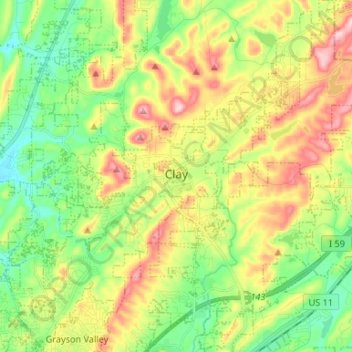
Name: Clay topographic map, elevation, terrain.
Location: Clay, Jefferson County, Alabama, 35048, United States (33.64424 -86.66513 33.75431 -86.53685)
Average elevation: 935 ft
Minimum elevation: 607 ft
Maximum elevation: 1,427 ft
Jefferson County trails, hiking, mountain biking, running and outdoor activities
Other topographic maps
Click on a map to view its topography, its elevation and its terrain.
Loch Haven Park
United States > Alabama > Jefferson County > Hoover > Cedar Crest
Average elevation: 522 ft
Warrior
United States > Alabama > Jefferson County > Warrior
Warrior is in the Central time zone. The elevation at the center of town is 564 feet (172 m), though it ranges from over 620 feet (190 m) north of the center to less than 300 feet (91 m) along the Locust Fork of the Black Warrior River, which forms the southern boundary of the city.
Average elevation: 489 ft
Fultondale
United States > Alabama > Jefferson County > Fultondale
Due to difficult topography, for many years Fultondale was limited in its ability to grow. However, as technology improved, the ability to convert what had been difficult to unusable land for retail and commercial purposes improved. Besides the retail development of Colonial Promenade, other retail development…
Average elevation: 623 ft
Warrior
United States > Alabama > Jefferson County > Warrior > Warrior
Warrior is in the Central time zone. The elevation at the center of town is 564 feet (172 m), though it ranges from over 620 feet (190 m) north of the center to less than 300 feet (91 m) along the Locust Fork of the Black Warrior River, which forms the southern boundary of the city.
Average elevation: 469 ft
Gardendale
United States > Alabama > Jefferson County > Gardendale > Gardendale
Average elevation: 594 ft
Hunters Hill
United States > Alabama > Jefferson County > Irondale > Hunters Hill
Average elevation: 784 ft
Country Haven
United States > Alabama > Jefferson County > Kimberly > Country Haven
Average elevation: 453 ft
The Drifttracks
United States > Alabama > Jefferson County > Birmingham > The Drifttracks
Average elevation: 574 ft