Geolocate

Hale County topographic map

Interactive map

Click on the map to display elevation.

About this map

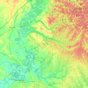
Name: Hale County topographic map, elevation, terrain.

Location: Hale County, Alabama, United States (32.46913 -87.87066 33.00701 -87.42028)

Average elevation: 213 ft

Minimum elevation: 52 ft

Maximum elevation: 594 ft

Alabama trails, hiking, mountain biking, running and outdoor activities

Other topographic maps

Click on a map to view its topography, its elevation and its terrain.

Fairhope

United States > Alabama > Baldwin County > Fairhope

According to the U.S. Census Bureau, the city has a total area of 12.0 square miles (31.1 km2), of which 0.019 square mile (0.05 km2), or 0.16%, is water. Its elevation ranges from sea level at the bay to 122 feet (37 m) in the city center.

Average elevation: 115 ft

Dauphin Island

United States > Alabama > Mobile County

Average elevation: 0 ft

Eastwood

United States > Alabama > Jefferson County > Birmingham

Average elevation: 640 ft

Bendale

United States > Alabama > Jefferson County > Birmingham

Average elevation: 604 ft

Opelika

United States > Alabama > Lee County > Opelika

Average elevation: 784 ft

Cedar Crest

United States > Alabama > Jefferson County > Hoover

Average elevation: 531 ft

Flat Rock

United States > Alabama > Lawrence County

Average elevation: 725 ft

Harpers Store

United States > Alabama > Conecuh County

Average elevation: 413 ft

Magazine

United States > Alabama > Mobile County > Mobile

Average elevation: 20 ft

Monte Vista

United States > Alabama > Etowah County > Gadsden

Average elevation: 719 ft

Flatwoods

United States > Alabama > Tuscaloosa County > Northport

Average elevation: 253 ft

Sand Mountain

United States > Alabama > Tuscaloosa County

Average elevation: 331 ft

Coopers Lake

United States > Alabama > Baldwin County

Average elevation: 161 ft

Forest Park

United States > Alabama > Jefferson County > Birmingham

Average elevation: 761 ft

Mentone

United States > Alabama > DeKalb County

Mentone is a town in DeKalb County, Alabama, United States. Mentone, located atop Lookout Mountain, has the highest elevation of any incorporated town in Alabama, and narrowly higher than Hytop.

Average elevation: 1,542 ft

Oaks Heights

United States > Alabama > Pike County > Troy

Average elevation: 486 ft

Gasque

United States > Alabama > Baldwin County

Average elevation: 7 ft

Center

United States > Alabama > Winston County

Average elevation: 915 ft

Madison

United States > Alabama > Jefferson County > Brighton

Average elevation: 535 ft

Park Place

United States > Alabama > Jefferson County > Birmingham

Average elevation: 617 ft

Ai

United States > Alabama > Cleburne County

Average elevation: 978 ft

Bluff Park

United States > Alabama > Jefferson County > Hoover

Average elevation: 810 ft

Lake Purdy

United States > Alabama > Shelby County > Brook Highland

Average elevation: 614 ft

Blueberry Estates

United States > Alabama > Shelby County > Pelham

Average elevation: 509 ft

Crest Estates

United States > Alabama > Jefferson County > Hoover

Average elevation: 817 ft

Stonehedge

United States > Alabama > Jefferson County > Birmingham

Average elevation: 889 ft

Saint Ives

United States > Alabama > Talladega County

Average elevation: 515 ft

Cottondale

United States > Alabama > Tuscaloosa County > Tuscaloosa

Average elevation: 305 ft

Micaville

United States > Alabama > Cleburne County

Average elevation: 1,181 ft

Seminole Heights

United States > Alabama > Houston County

Average elevation: 266 ft

Gulf Dale

United States > Alabama > Mobile County > Mobile

Average elevation: 23 ft

Lime Kiln

United States > Alabama > Colbert County

Average elevation: 528 ft

Carolwood

United States > Alabama > Tuscaloosa County

Average elevation: 325 ft

Ridgefield

United States > Alabama > Montgomery County > Montgomery

Average elevation: 259 ft

Vanderbilt

United States > Alabama > Jefferson County > Birmingham

Average elevation: 607 ft

West End

United States > Alabama > Jefferson County > Birmingham

Average elevation: 577 ft

Brentwood

United States > Alabama > Montgomery County > Montgomery

Average elevation: 246 ft

Liberty Hill

United States > Alabama > Franklin County

Average elevation: 928 ft

Ono Island

United States > Alabama > Baldwin County

Ono Island was along the boundary of the treaties between France and Spain. In 1813, after protests and attempts at rebellion, President James Monroe seized Spanish lands west of the Perdido River and declared them a part of the Louisiana Purchase of 1803. This set the east end of the Island, Perdido Key, at…

Average elevation: 30 ft

Camp Sequoyah Dam

United States > Alabama > Etowah County

Average elevation: 856 ft

Norwood

United States > Alabama > Mobile County > Chickasaw

Average elevation: 26 ft

Jeff

United States > Alabama > Madison County

Average elevation: 814 ft

Cloverdale

United States > Alabama > Montgomery County > Montgomery

Average elevation: 243 ft

Rabun

United States > Alabama > Baldwin County

Average elevation: 240 ft

Red Hill

United States > Alabama > Elmore County

Average elevation: 525 ft

Minooka Park

United States > Alabama > Chilton County > Jemison

Average elevation: 604 ft

Summit Place

United States > Alabama > Madison County > Huntsville

Average elevation: 699 ft

Ardell

United States > Alabama > Cullman County

Average elevation: 577 ft

Old Harmony

United States > Alabama > Etowah County > Rainbow City

Average elevation: 600 ft

Grove Hill

United States > Alabama > Monroe County

Average elevation: 85 ft

Danville

United States > Alabama > Jefferson County > Tarrant

Average elevation: 617 ft

Red Level

United States > Alabama > Montgomery County

Average elevation: 315 ft

Ridgewood

United States > Alabama > Madison County > Huntsville

Average elevation: 886 ft

Bon-Air

United States > Alabama > Jefferson County > Brighton

Average elevation: 541 ft

West Hill

United States > Alabama > Mobile County > Mobile

Average elevation: 180 ft

Bear Creek

United States > Alabama > Franklin County > Red Bay

Average elevation: 627 ft

Lakeview

United States > Alabama > Lauderdale County

Average elevation: 574 ft

Union

United States > Alabama > Calhoun County

Average elevation: 564 ft

Smithdale

United States > Alabama > Cullman County > Cullman

Average elevation: 879 ft

Anderson

United States > Alabama > Cherokee County

Average elevation: 617 ft

Pine Level

United States > Alabama > Autauga County

Average elevation: 512 ft

Alliance

United States > Alabama > Jefferson County

Average elevation: 404 ft

Hugo

United States > Alabama > Marengo County

Average elevation: 167 ft

Windsor Forest

United States > Alabama > Lee County > Auburn

Average elevation: 620 ft

Johnstown

United States > Alabama > Montgomery County > Montgomery

Average elevation: 230 ft

Quail Run

United States > Alabama > Mobile County > Tillmans Corner

Average elevation: 115 ft

Oak Mountain

United States > Alabama > Calhoun County > Anniston

Average elevation: 1,234 ft

Mount Olive

United States > Alabama > Jackson County

Average elevation: 1,355 ft

Camp Comer Dam

United States > Alabama > DeKalb County

Average elevation: 1,608 ft

Elsmeade

United States > Alabama > Montgomery County > Montgomery

Average elevation: 213 ft

Dawson

United States > Alabama > DeKalb County

Average elevation: 1,007 ft

Adamsburg

United States > Alabama > DeKalb County

Average elevation: 1,388 ft

Jones Chapel

United States > Alabama > Cullman County

Average elevation: 869 ft

Mineral Springs

United States > Alabama > Jefferson County

Average elevation: 538 ft

Dees

United States > Alabama > Mobile County

Average elevation: 108 ft

Douglasville

United States > Alabama > Baldwin County > Bay Minette

Average elevation: 246 ft

Greer

United States > Alabama > Elmore County

Average elevation: 492 ft

Alton

United States > Alabama > Jefferson County > Irondale

Average elevation: 794 ft

Higdon

United States > Alabama > Jackson County

Average elevation: 1,378 ft

Flat Rock

United States > Alabama > Jackson County

Average elevation: 1,385 ft