
Parke County topographic map
Interactive map
Click on the map to display elevation.
About this map
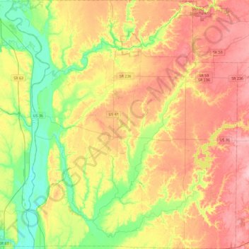
Name: Parke County topographic map, elevation, terrain.
Location: Parke County, Indiana, United States (39.60479 -87.43468 39.95293 -87.00948)
Average elevation: 653 ft
Minimum elevation: 453 ft
Maximum elevation: 863 ft
Indiana trails, hiking, mountain biking, running and outdoor activities
Other topographic maps
Click on a map to view its topography, its elevation and its terrain.
Indianapolis
United States > Indiana > Indianapolis
Indianapolis is within the Tipton Till Plain, a flat to gently sloping terrain underlain by glacial deposits known as till. The lowest point in the city is about 650 feet (198 m) above mean sea level, with the highest natural elevation at about 900 feet (274 m) above sea level. Few hills or short ridges, known…
Average elevation: 791 ft
Johnson Lake
United States > Indiana > Jefferson County > Madison > North Madison
Average elevation: 873 ft
Fort Benjamin Harrison State Park and Nature Preserve
United States > Indiana > Marion County > Indianapolis
Average elevation: 833 ft
Country Club Meadows
United States > Indiana > Vanderburgh County > Evansville
Average elevation: 413 ft
Happy Hollow Heights
United States > Indiana > Tippecanoe County > West Lafayette > Happy Hollow Heights
Average elevation: 620 ft
Fox Hollow
United States > Indiana > Marion County > Indianapolis > Fox Hollow
Average elevation: 827 ft
Fort Wayne
United States > Indiana > Allen County > Fort Wayne
The first settlement started in 1815. In 1819, the military garrison abandoned the fort and moved to Detroit. In 1822, a federal land office opened to sell land ceded by local Native Americans by the Treaty of St. Mary's in 1818. Platted in 1823 at the Ewing Tavern, the village became an important frontier…
Average elevation: 814 ft