
Chaffee County topographic map
Interactive map
Click on the map to display elevation.
About this map
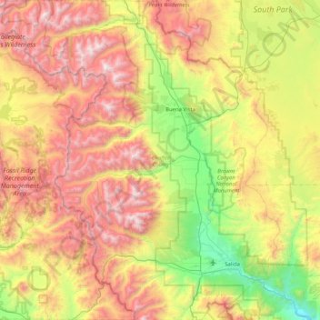
Name: Chaffee County topographic map, elevation, terrain.
Location: Chaffee County, Colorado, United States (38.42209 -106.59981 39.05785 -105.87803)
Average elevation: 9,908 ft
Minimum elevation: 6,640 ft
Maximum elevation: 14,337 ft
Colorado trails, hiking, mountain biking, running and outdoor activities
Other topographic maps
Click on a map to view its topography, its elevation and its terrain.
Evergreen
United States > Colorado > Jefferson County
Evergreen sits at an elevation of 7,220 feet (2,200 m) in the Rocky Mountains, 19 miles west of Denver, Colorado. Its addresses are oriented according to the Street_system_of_Denver.
Average elevation: 7,575 ft
Pikes Peak
United States > Colorado > El Paso County
Soils on Pikes Peak above the timberline (approximately 12,000 ft or 3,700 m) are classified as Cirque land. Forests at lower altitudes mostly lie over the brown stony, sandy, loams of the Catamount loam or Ivywild loam series.
Average elevation: 12,802 ft
Lakewood
United States > Colorado > Jefferson County > Lakewood
Lakewood is located at 39°42′17″N 105°04′53″W / 39.70472°N 105.08139°W / 39.70472; -105.08139 at an elevation of 5,518 feet (1,682 m). Located at the junction of U.S. Route 6 and Colorado State Highway 121 in central Colorado, the city lies immediately west of Denver and 62 miles (100 km)…
Average elevation: 5,633 ft
Estes Park
United States > Colorado > Larimer County
Estes Park sits at an elevation of 7,522 feet (2,293 m) on the front range of the Rocky Mountains at the eastern entrance of the Rocky Mountain National Park. Its north, south and east extremities border the Roosevelt National Forest. Lumpy Ridge lies immediately north of Estes Park.
Average elevation: 8,343 ft
Fairplay
United States > Colorado > Park County
The historic Town of Fairplay is the Statutory Town that is the county seat and the most populous municipality of Park County, Colorado, United States. The town population was 724 at the 2020 United States Census. Fairplay is located in South Park at an elevation of 9,953 feet (3,034 m). The town is the…
Average elevation: 9,990 ft
Bennett
United States > Colorado > Adams County
Bennett is located at coordinates 39°45′32″N 104°25′39″W / 39.7589°N 104.4275°W / 39.7589; -104.4275 at an elevation of 5486 at the intersection of State Highways 36 and 79, just north of Interstate 70.
Average elevation: 5,551 ft
Doublehead Mountain
United States > Colorado > Jefferson County > Aspen Park
Average elevation: 8,097 ft
Bennett
United States > Colorado > Adams County
Bennett is located at coordinates 39°45′32″N 104°25′39″W / 39.7589°N 104.4275°W / 39.7589; -104.4275 at an elevation of 5486 at the intersection of State Highways 36 and 79, just north of Interstate 70.
Average elevation: 5,551 ft
Berthoud Pass
United States > Colorado > Clear Creek County
Berthoud Pass (/ˈbɜːrθəd/ BURTH-əd; elevation 11,307 ft (3,446 m)) is a high mountain pass in central Colorado, in the Front Range of the Rocky Mountains of the western United States.
Average elevation: 11,427 ft
Crested Butte
United States > Colorado > Gunnison County
Crested Butte is located in north-central Gunnison County on the west side of the valley of the Slate River, along Coal Creek. Colorado State Highway 135 runs south from Crested Butte 27 miles (43 km) to Gunnison, the county seat. According to the United States Census Bureau, the town of Crested Butte has a…
Average elevation: 9,180 ft
Vail
United States > Colorado > Eagle County
Vail's average elevation is 8,150 feet (2484 m) above sea level. The town has a total area of 4.5 square miles (12 km2), with no lakes (there is, however, at least one pond). Gore Creek flows from east to west through the center of town.
Average elevation: 9,688 ft
Berthoud Pass
United States > Colorado > Clear Creek County
Berthoud Pass (/ˈbɜːrθəd/ BURTH-əd; elevation 11,307 ft (3,446 m)) is a high mountain pass in central Colorado, in the Front Range of the Rocky Mountains of the western United States.
Average elevation: 11,427 ft
Estes Park
United States > Colorado > Larimer County
Estes Park sits at an elevation of 7,522 feet (2,293 m) on the front range of the Rocky Mountains at the eastern entrance of the Rocky Mountain National Park. Its north, south and east extremities border the Roosevelt National Forest. Lumpy Ridge lies immediately north of Estes Park.
Average elevation: 7,969 ft
Ouray
United States > Colorado > Ouray County
Ouray (/ˈjʊəreɪ/ YOOR-ay) is a home rule municipality that is the county seat of Ouray County, Colorado, United States. The city population was 898 as of the 2020 census. The Ouray Post Office has the ZIP Code 81427. Located at an elevation of 7,792 feet (2,375 m), Ouray's climate, natural alpine…
Average elevation: 8,914 ft
Mount Elbert
United States > Colorado > Lake County
Mount Elbert is the highest summit of the Rocky Mountains of North America. With an elevation of 14,438 feet (4400.58 m), it is also the highest point in the U.S. state of Colorado and the second-highest summit in the contiguous United States after Mount Whitney, which is slightly taller. The ultra-prominent…
Average elevation: 12,989 ft
Evergreen
United States > Colorado > Jefferson County
Evergreen sits at an elevation of 7,220 feet (2,200 m) in the Rocky Mountains, 19 miles west of Denver, Colorado.
Average elevation: 7,575 ft
Ben Lomand Mountain
United States > Colorado > El Paso County > Palmer Lake
Average elevation: 7,283 ft
Berthoud Pass
United States > Colorado > Clear Creek County
Berthoud Pass (/ˈbɜːrθəd/ BURTH-əd; elevation 11,307 ft (3,446 m)) is a high mountain pass in central Colorado, in the Front Range of the Rocky Mountains of the western United States.
Average elevation: 11,427 ft
Sleepy Cat Peak
United States > Colorado > Rio Blanco County
Sleepy Cat Peak, elevation 10,853 ft (3,308 m), is a summit in the Flat Tops of northwest Colorado. The mountain is east of Meeker in the White River National Forest of Rio Blanco County.
Average elevation: 10,138 ft
Cottonwood Pass
United States > Colorado > Chaffee County
Cottonwood Pass (elevation 12,119 feet (3,694 m)) is a high mountain pass on the Continental Divide in south-central Colorado in the Rocky Mountains of the western United States. It is located along the border of Gunnison and Chaffee counties in Colorado, and is in the Sawatch Range. The road over Cottonwood…
Average elevation: 11,913 ft
Tower Mountain
United States > Colorado > San Juan County
Tower Mountain, elevation 13,558 ft (4,132 m), is a summit located northeast of Silverton, Colorado.
Average elevation: 12,395 ft
Buena Vista
United States > Colorado > Chaffee County
Buena Vista is located in central Colorado roughly midway between Salida and Leadville in the Upper Arkansas River Valley at an elevation of 7,965 feet (2,428 m). The area between Buena Vista and Salida is often referred to as the Denver & Rio Grande, South Park & Pacific, and Colorado Midland railroads. Many…
Average elevation: 8,061 ft
Cheyenne Mountain State Park
United States > Colorado > El Paso County > Colorado Springs
Average elevation: 7,028 ft
Tabernash
United States > Colorado > Grand County > Tabernash
On August 10, 1984, a Cessna L-19 Bird Dog (registration N4584A), piloted by James Jeb Caddell, 36, crashed in a forest near Tabernash. The aircraft was en route from Granby to Jeffco Airport, Colorado. Despite the efforts of a search party, the two men could not be located, as the plane had flipped over and…
Average elevation: 8,507 ft
Grand Lake
United States > Colorado > Grand County
Established in 1881, Grand Lake sits at an elevation of 8,369 feet (2,551 m) and derives its name from the lake on whose shores it is situated: Grand Lake, the largest natural body of water in Colorado. The town of Grand Lake was originally an outfitting and supply point for the mining settlements of Lulu…
Average elevation: 8,629 ft
Hidden Mesa Open Space
United States > Colorado > Douglas County > Castle Rock
Average elevation: 6,240 ft
Torreys Peak
United States > Colorado > Clear Creek County
The third trail starts at Loveland Pass about 4.5 miles (7.2 km) to the northwest. To reach Loveland Pass, follow I-70 west from Denver 55 miles (89 km) to where US Route 6 breaks off and heads south. Follow the meandering Route 6 approximately seven miles to the trailhead at Loveland Pass, at an elevation of…
Average elevation: 12,644 ft
Monument
United States > Colorado > El Paso County
Monument experiences a hemiboreal continental climate (Köppen Dfb) with warm, relatively rainy summers and cold, snowy winters. The semi-arid climate keeps the dew point very low in Monument year-round which causes the air to feel quite dry. Monument is part of the Front Range urban corridor and lies on the…
Average elevation: 7,087 ft
Alma
United States > Colorado > Park County
At an elevation of approximately 10,578 feet (3,224 m), Alma is the highest incorporated municipality in the United States when considering only areas with permanent residents. Its post office is located at the highest elevation of any in the country. Alma, which is considered a town and not a city, does not…
Average elevation: 10,538 ft