
Leon County topographic map
Click on the map to display elevation.
About this map
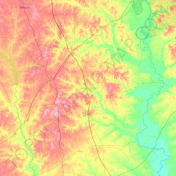
Name: Leon County topographic map, elevation, terrain.
Location: Leon County, Texas, United States (30.97397 -96.33108 31.65419 -95.65538)
Average elevation: 344 ft
Minimum elevation: 138 ft
Maximum elevation: 614 ft
Texas trails, hiking, mountain biking, running and outdoor activities
Other topographic maps
Click on a map to view its topography, its elevation and its terrain.
Enchanted Rock
United States > Texas > Llano County
Enchanted Rock is a pink granite mountain located in the Llano Uplift about 17 miles (27 km) north of Fredericksburg, Texas and 24 miles (39 km) south of Llano, Texas, United States. Enchanted Rock State Natural Area, which includes Enchanted Rock and surrounding land, spans the border between Gillespie and…
Average elevation: 1,486 ft
Padre Island National Seashore
United States > Texas > Kenedy County > Corpus Christi
Average elevation: 16 ft
Flint
United States > Texas > Smith County
Flint is an unincorporated community in southeastern Smith County, Texas, United States. It lies along FM 2493, south of the city of Tyler, the county seat of Smith County. Its elevation is 522 feet (159 m). Although Flint is unincorporated, it has a post office, with the ZIP code of 75762.
Average elevation: 479 ft
Choke Canyon State Park - Calliham Unit
United States > Texas > McMullen County > Calliham
Average elevation: 220 ft