
South District topographic map
Interactive map
Click on the map to display elevation.
About this map
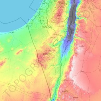
Name: South District topographic map, elevation, terrain.
Location: South District, Israel (29.48779 34.26750 31.87282 35.47601)
Average elevation: 1,575 ft
Minimum elevation: -1,362 ft
Maximum elevation: 5,627 ft
Other topographic maps
Click on a map to view its topography, its elevation and its terrain.
Dimona
Dimona is located in the Negev Desert. The city stands at an elevation of around 550–600 metres (1,800–1,970 ft) above sea level.
Average elevation: 1,834 ft
Zur Hadassa
Tzur Hadassah (Hebrew: צוּר הֲדַסָּה, lit. Rock of Hadassah) is a local council located in the Jerusalem Corridor, located 12 kilometres (7.5 mi) southwest of Jerusalem, at an altitude of 755 meters above sea level, located on Route 375 west of Betar Ilit, about one kilometer west of the Green…
Average elevation: 2,303 ft
2236 Mt. Hermon
Israel > North District > Golan Regional Council
Mount Hermon (Arabic: جبل الشيخ or جبل حرمون / ALA-LC: Jabal al-Shaykh ('Mountain of the Sheikh') or Jabal Haramun; Hebrew: הַר חֶרְמוֹן, Har Ḥermōn) is a mountain cluster constituting the southern end of the Anti-Lebanon mountain range. Its summit straddles the border between…
Average elevation: 6,614 ft
Karmiel
Karmiel is located on the Acre–Safed road, on the northern edge of the Lower Galilee. It lies in the Beit HaKerem Valley and its elevation is 330 m (1,082.68 ft). The Hilazon Stream passes slightly to the south of Karmiel. Its tributaries, the Shezor and Shagor Streams pass through Karmiel on the east and…
Average elevation: 791 ft
Nazareth
Israel > North District > Nazareth
As of the early 1990s, no city plans drafted by Nazareth Municipality have been approved by the government (both the British Mandate and later Israel) since 1942. This has left many people in Nazareth who vote in the city's municipal elections and receive services from its municipality effectively outside of…
Average elevation: 1,178 ft
Bat Hefer
Israel > Center District > Emek Hefer Regional Council > Bat Hefer
Average elevation: 187 ft
Mishmar HaEmek
Israel > North District > Megido Regional Council > Mishmar HaEmek
Average elevation: 410 ft
Deganya Alef
Israel > North District > Emek HaYarden Regional Council > Deganya Alef
Average elevation: -659 ft
Tiberias
Tiberias is located on the shore of the Sea of Galilee and the western slopes of the Jordan Rift Valley overlooking the lake, in the elevation range of −200 to 200 metres (−660–660 feet). Tiberias has a climate that borders a Hot-summer Mediterranean climate (koppen Csa) and a Hot Semi-arid climate…
Average elevation: -7 ft
Sde Boker
Israel > South District > Ramat Negev Regional Council > Sde Boker
Average elevation: 1,594 ft
Modiin-Maccabim-Reut
Israel > Center District > Ramla Subdistrict > Modiin-Maccabim-Reut
Average elevation: 787 ft
Nazareth
Israel > North District > Nazareth
As of the early 1990s, no city plans drafted by Nazareth Municipality have been approved by the government (both the British Mandate and later Israel) since 1942. This has left many people in Nazareth who vote in the city's municipal elections and receive services from its municipality effectively outside of…
Average elevation: 495 ft