
Nyingchi Prefecture topographic map
Interactive map
Click on the map to display elevation.
About this map
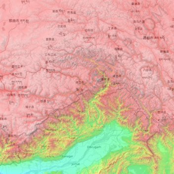
Name: Nyingchi Prefecture topographic map, elevation, terrain.
Location: Nyingchi Prefecture, Tibet, 860000, China (28.10718 92.16474 30.66861 98.75310)
Average elevation: 11,342 ft
Minimum elevation: 174 ft
Maximum elevation: 24,121 ft
Other topographic maps
Click on a map to view its topography, its elevation and its terrain.
Mount Makalu
China > Tibet > Tingri County
Makalu (Nepali: मकालु हिमाल, romanized: Makālu himāl; Chinese: 马卡鲁峰; pinyin: Mǎkǎlǔ Fēng) is the fifth-highest mountain on Earth, with a summit at an elevation of 8,485 metres (27,838 ft) AMSL. It is located in the Mahalangur Himalayas 19 km (12 mi) southeast of Mount Everest,…
Average elevation: 24,537 ft
Lhasa
Lhasa has an elevation of about 3,600 m (11,800 ft) and lies in the centre of the Tibetan Plateau with the surrounding mountains rising to 5,500 m (18,000 ft). The air only contains 68 percent of the oxygen compared to sea level. The Lhasa River, also Kyi River or Kyi Chu, a tributary of the Yarlung Zangbo…
Average elevation: 14,370 ft
Chumbi Valley
China > Tibet > Yadong County > Xiayadong > Rinchengang
The valley is at an altitude of 3,000 m (9,800 ft), and being on the south side of the Himalayas, enjoys a wetter and more temperate climate than most of Tibet. The valley supports some vegetation in the form of the Eastern Himalayan broadleaf forests and transitions to the Eastern Himalayan alpine shrub and…
Average elevation: 10,092 ft
Lhotse
China > Tibet > Tingri County
Lhotse (Nepali: ल्होत्से, romanized: L'hōtsē [lotse]; Standard Tibetan: ལྷོ་རྩེ, romanized: lho tse, lit. 'South Peak' [l̥otse]; Chinese: 洛子峰) is the fourth-highest mountain on Earth, after Mount Everest, K2, and Kangchenjunga. At an elevation of 8,516 metres (27,940…
Average elevation: 24,249 ft
Nagqu
Nagqu is located in the northeast of Tibet. Nagqu Town is 330 kilometres (210 mi) by the China National Highway 109 northeast of Lhasa. Nagqu is bordered by Bayingolin and Hotan Prefectures of Xinjiang to the north, Haixi, Yushu Prefectures of Qinghai and Chamdo to the east, Nyingchi, Lhasa and Shigatse to the…
Average elevation: 15,171 ft
Nyingchi
The average elevation of Nyingchi is 3,040 meters (9,974 feet), which is the lowest compared with the other prefectures in Tibet. So, the risk of getting high-altitude sickness is relatively lower than other parts on the plateau. Guangdong province announced in 2012 that it plans to invest more than RMB 400…
Average elevation: 13,238 ft
Lhoka
China > Tibet > Tsetang Township
Shannan has 1 district and 11 counties and its capital is Tsetang, which is located 183 kilometres from Lhasa. It covers an area of 79,700 square kilometres (30,800 sq mi), which includes part of South Tibet, a disputed territory currently under control of the Indian state of Arunachal Pradesh. Its topography…
Average elevation: 13,609 ft