
Aroostook County topographic map
Interactive map
Click on the map to display elevation.
Aroostook County
According to the U.S. Census Bureau, the county has a total area of 6,828 square miles (17,680 km2), of which 6,671 square miles (17,280 km2) is land and 156 square miles (400 km2) (2.3%) is water. Aroostook County is Maine's largest county by area, about the size of Connecticut and Rhode Island combined. The county high point is Peaked Mountain, elevation 2,230 feet (680 m), whose western slopes are in the north east corner of Piscataquis County.
About this map
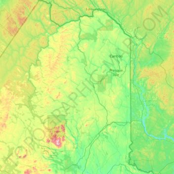
Name: Aroostook County topographic map, elevation, terrain.
Location: Aroostook County, Maine, United States (45.57286 -70.02320 47.45984 -67.75063)
Average elevation: 899 ft
Minimum elevation: 125 ft
Maximum elevation: 4,911 ft
Maine trails, hiking, mountain biking, running and outdoor activities
Other topographic maps
Click on a map to view its topography, its elevation and its terrain.
Height of Land Scenic Overlook
United States > Maine > Franklin County > Township D > Rangeley Plantation
Average elevation: 1,972 ft
Jones Pond
United States > Maine > Somerset County > Bald Mountain Township T4 R3
Average elevation: 1,650 ft
Monhegan Island
United States > Maine > Lincoln County > Monhegan Island Plantation > Monhegan
Average elevation: 16 ft
Sandy River Plantation
United States > Maine > Franklin County > Sandy River Plantation
Average elevation: 1,932 ft
Estcourt Station
United States > Maine > Aroostook County
Estcourt Station (elevation: 671 ft (205 m), pop. 4) is a village within the Big Twenty Township in the state of Maine. It is the northernmost point in the United States east of the Great Lakes. The ZIP Code for Estcourt Station is 04741. Although part of Maine, the village uses Quebec, Canada area code 418.
Average elevation: 879 ft
Littlejohn Island
United States > Maine > Cumberland County > Yarmouth > Cousins Island
Average elevation: 16 ft
East Livermore
United States > Maine > Androscoggin County > Livermore Falls
Average elevation: 364 ft
Matinicus Island
United States > Maine > Knox County > Matinicus Isle Plantation
Matinicus Isle plantation is an archipelago located on the southeastern fringes of Penobscot Bay in the Gulf of Maine, part of the Atlantic Ocean. According to the United States Census Bureau, the plantation has a total area of 9.9 square miles (26 km2), of which 2.3 square miles (6.0 km2) is land and 7.6…
Average elevation: 16 ft
West Boothbay Harbor
United States > Maine > Lincoln County > Boothbay Harbor
Average elevation: 33 ft