Geolocate

Marinette County topographic map

Interactive map

Click on the map to display elevation.

About this map

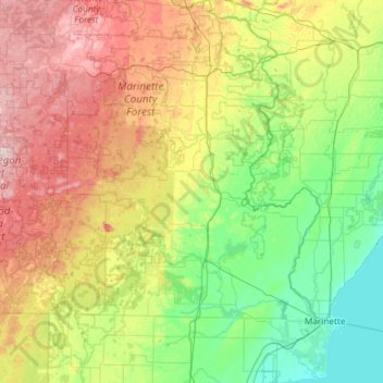
Name: Marinette County topographic map, elevation, terrain.

Location: Marinette County, Wisconsin, United States (44.96429 -88.42809 45.79564 -87.57386)

Average elevation: 935 ft

Minimum elevation: 568 ft

Maximum elevation: 1,755 ft

Wisconsin trails, hiking, mountain biking, running and outdoor activities

Other topographic maps

Click on a map to view its topography, its elevation and its terrain.

Morgan Falls

United States > Wisconsin > Ashland County

Average elevation: 1,319 ft

Madison

United States > Wisconsin > Dane County

The city is sometimes described as The City of Four Lakes, comprising the four successive lakes of the Yahara River: Lake Mendota ("Fourth Lake"), Lake Monona ("Third Lake"), Lake Waubesa ("Second Lake") and Lake Kegonsa ("First Lake"), although Waubesa and Kegonsa are not actually in Madison, but just south…

Average elevation: 948 ft

Petersburg

United States > Wisconsin > Crawford County

Average elevation: 863 ft

Waunakee Marsh

United States > Wisconsin > Dane County > Waunakee

Average elevation: 958 ft

Lake Nokomis

United States > Wisconsin > Bayfield County

Average elevation: 1,188 ft

Mount Zion

United States > Wisconsin > Rock County

Average elevation: 938 ft

Poskin Lake

United States > Wisconsin > Barron County

Average elevation: 1,194 ft

Chicago Island

United States > Wisconsin > Lincoln County > Tomahawk

Average elevation: 1,447 ft

Peru

United States > Wisconsin > Portage County

Average elevation: 1,138 ft

Germania

United States > Wisconsin > Marquette County

Average elevation: 810 ft

Hawthorne

United States > Wisconsin > Douglas County

Average elevation: 1,171 ft

Leeman

United States > Wisconsin > Outagamie County

Average elevation: 791 ft

Summit Lake

United States > Wisconsin > Langlade County

Average elevation: 1,709 ft

Lynn

United States > Wisconsin > Clark County

The history of Lynn, Wisconsin is deeply rooted in the early settlement and development of Clark County. Topics covered in the history of Clark County, Wisconsin, include topography, Indians, early government, early settlement, politics, lumbering, transportation, agriculture, education, the press, the courts,…

Average elevation: 1,165 ft

Horicon Marsh

United States > Wisconsin > Dodge County

Average elevation: 860 ft

Meteor

United States > Wisconsin > Sawyer County

Average elevation: 1,670 ft

Cainville

United States > Wisconsin > Rock County

Average elevation: 932 ft

Cedar Lake

United States > Wisconsin > Washington County > Slinger

Average elevation: 1,079 ft

Hager City

United States > Wisconsin > Pierce County

Average elevation: 797 ft

Bowens Addition

United States > Wisconsin > Dane County > Madison

Average elevation: 873 ft

Cable

United States > Wisconsin > Bayfield County

Average elevation: 1,371 ft

Holy Hill

United States > Wisconsin > Washington County

Average elevation: 1,115 ft

Bundy

United States > Wisconsin > Lincoln County

Average elevation: 1,663 ft

East Hill

United States > Wisconsin > Forest County > Crandon

Average elevation: 1,696 ft

Kansasville

United States > Wisconsin > Racine County

Average elevation: 820 ft

Brodhead Dam

United States > Wisconsin > Green County

Average elevation: 827 ft

Rodell

United States > Wisconsin > Eau Claire County

Average elevation: 965 ft

Silver Lake

United States > Wisconsin > Waushara County

Average elevation: 889 ft

Buena Park

United States > Wisconsin > Racine County

Average elevation: 804 ft

Capitol Square

United States > Wisconsin > Dane County > Madison

Average elevation: 860 ft

Champion

United States > Wisconsin > Brown County

Average elevation: 771 ft

Winneboujou

United States > Wisconsin > Douglas County > Town of Brule

Average elevation: 1,093 ft

Underhill

United States > Wisconsin > Oconto County

Average elevation: 817 ft

Devils Lake

United States > Wisconsin > Washburn County

Average elevation: 1,204 ft

Woods

United States > Wisconsin > Manitowoc County > Manitowoc

Average elevation: 686 ft

White Creek

United States > Wisconsin > Adams County

Average elevation: 899 ft

Jonesdale

United States > Wisconsin > Iowa County

Average elevation: 1,004 ft

Saxon

United States > Wisconsin > Iron County

Average elevation: 1,112 ft

Heart Island

United States > Wisconsin > Barron County > Rice Lake

Average elevation: 1,227 ft

Fawn Lake

United States > Wisconsin > Burnett County

Average elevation: 988 ft

Wilson Park

United States > Wisconsin > Dunn County > Menomonie

Average elevation: 876 ft

Iron Belt

United States > Wisconsin > Iron County

Average elevation: 1,558 ft

Powell

United States > Wisconsin > Iron County

Average elevation: 1,598 ft

Montfort Junction

United States > Wisconsin > Iowa County

Average elevation: 1,168 ft

Edmund

United States > Wisconsin > Iowa County

Average elevation: 1,152 ft

Medary

United States > Wisconsin > La Crosse County > La Crosse

Average elevation: 741 ft

Ellison Bay

United States > Wisconsin > Door County

Average elevation: 636 ft

Abells Corners

United States > Wisconsin > Walworth County

Average elevation: 902 ft

Fish Creek

United States > Wisconsin > Door County

Average elevation: 620 ft

Stitzer

United States > Wisconsin > Grant County

Average elevation: 1,086 ft

Martintown

United States > Wisconsin > Green County

Average elevation: 827 ft

Troy Center

United States > Wisconsin > Walworth County

Average elevation: 883 ft

Avalon

United States > Wisconsin > Rock County

Average elevation: 948 ft

Spring Grove

United States > Wisconsin > Green Lake County

Average elevation: 853 ft

Kieler

United States > Wisconsin > Grant County

Average elevation: 902 ft

Burnett

United States > Wisconsin > Dodge County

Average elevation: 892 ft

Tuleta Hills

United States > Wisconsin > Green Lake County

Average elevation: 837 ft

Sandy Hook

United States > Wisconsin > Grant County

Average elevation: 804 ft

Fairburn

United States > Wisconsin > Green Lake County

Average elevation: 771 ft

Millard

United States > Wisconsin > Walworth County

Average elevation: 928 ft

Sinsinawa

United States > Wisconsin > Grant County

Average elevation: 909 ft

Center House

United States > Wisconsin > Green Lake County

Average elevation: 951 ft

Twin Grove

United States > Wisconsin > Green County

Average elevation: 991 ft

Stearns

United States > Wisconsin > Green County

Average elevation: 1,027 ft

Ross Crossing

United States > Wisconsin > Green County

Average elevation: 919 ft

Postville

United States > Wisconsin > Green County

Average elevation: 1,086 ft

Oakley

United States > Wisconsin > Green County

Average elevation: 915 ft

Greenwyck

United States > Wisconsin > Green Lake County

Average elevation: 840 ft

Indian Hills

United States > Wisconsin > Green Lake County

Average elevation: 837 ft

Utley

United States > Wisconsin > Green Lake County

Average elevation: 955 ft

Lima Center

United States > Wisconsin > Rock County

Average elevation: 899 ft

Foxhollow

United States > Wisconsin > Rock County > Town of Turtle

Average elevation: 912 ft

Tomahawk Lake

United States > Wisconsin > Washburn County

Average elevation: 1,043 ft

Tibbets

United States > Wisconsin > Walworth County

Average elevation: 925 ft

Tiffany

United States > Wisconsin > Rock County > Town of Turtle

Average elevation: 860 ft

Whitefish Bay

United States > Wisconsin > Door County

Average elevation: 600 ft

Juda

United States > Wisconsin > Green County

Average elevation: 902 ft

Lake Wisconsin

United States > Wisconsin > Columbia County

Average elevation: 794 ft

Ashippun

United States > Wisconsin > Dodge County

Average elevation: 892 ft

Little Sturgeon

United States > Wisconsin > Door County

Average elevation: 587 ft

Town of Westport

United States > Wisconsin > Dane County

Average elevation: 876 ft