
Day County topographic map
Interactive map
Click on the map to display elevation.
About this map
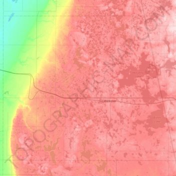
Name: Day County topographic map, elevation, terrain.
Location: Day County, South Dakota, United States (45.15117 -97.98165 45.58921 -97.22511)
Average elevation: 1,739 ft
Minimum elevation: 1,286 ft
Maximum elevation: 2,028 ft
South Dakota trails, hiking, mountain biking, running and outdoor activities
Other topographic maps
Click on a map to view its topography, its elevation and its terrain.
Mount Rushmore
Mount Rushmore National Memorial is centered on a colossal sculpture carved into the granite face of Mount Rushmore (Lakota Tȟuŋkášila Šákpe, or Six Grandfathers) in the Black Hills in Keystone, South Dakota. Sculptor Gutzon Borglum created the sculpture's design and oversaw the project's execution from…
Average elevation: 5,125 ft
Eastwoods Park
United States > South Dakota > Codington County > Watertown
Average elevation: 1,785 ft
Kirby Dog Park at Fort Sod
United States > South Dakota > Minnehaha County > Sioux Falls
Average elevation: 1,447 ft
Brooking Municipal Utilitys
United States > South Dakota > Brookings County > Brookings
Average elevation: 1,614 ft
Sioux Council Boy Scout Reservation
United States > South Dakota > Yankton County
Average elevation: 1,355 ft
North Sioux City
United States > South Dakota > Union County > North Sioux City > North Sioux City
Average elevation: 1,158 ft
Groton City Limit
United States > South Dakota > Brown County > Groton City Limit
Average elevation: 1,306 ft
Vermillion
United States > South Dakota > Clay County > Vermillion
The elevation of the city is 1,221 feet (372 m).
Average elevation: 1,243 ft