
Make a donation
Gear up for your next adventure:
As an Amazon Associate, this site earns from qualifying purchases at no extra cost to you.
Harrisonburg topographic map
Click on the map to display elevation.
Make a donation
Gear up for your next adventure:
As an Amazon Associate, this site earns from qualifying purchases at no extra cost to you.
About this map
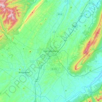
Name: Harrisonburg topographic map, elevation, terrain.
Location: Harrisonburg, Virginia, 22807, United States (38.28933 -79.02888 38.60933 -78.70888)
Average elevation: 1,463 ft
Minimum elevation: 965 ft
Maximum elevation: 3,694 ft
Virginia trails, hiking, mountain biking, running and outdoor activities
Make a donation
Gear up for your next adventure:
As an Amazon Associate, this site earns from qualifying purchases at no extra cost to you.
Other topographic maps
Click on a map to view its topography, its elevation and its terrain.
Carroll County
The first European settlers arrived in the region in the mid 18th century. These were primarily Scotch-Irish pioneers, who were used to high mountain altitudes. However, early settlement was slow, mostly due to the poor agricultural soil of the area. As a result, lead mining was one of the first economic…
Average elevation: 2,326 ft
Blue Ridge
United States > Virginia > Loudoun County
Blue Ridge Mountain is noticeably lower in elevation than other sections of the Blue Ridge Mountains in Virginia. The southern section of the mountain contains the highest peaks, and the ridge gradually loses elevation as it gets closer to the Potomac. Elevations in the gaps are typically around 1,000 feet…
Average elevation: 600 ft
Make a donation
Gear up for your next adventure:
As an Amazon Associate, this site earns from qualifying purchases at no extra cost to you.
Claytor Lake State Park
United States > Virginia > Pulaski County > Dublin
Average elevation: 1,893 ft
Make a donation
Gear up for your next adventure:
As an Amazon Associate, this site earns from qualifying purchases at no extra cost to you.
Occoquan Bay National Wildlife Refuge
United States > Virginia > Prince William County > Woodbridge
Average elevation: 10 ft
Make a donation
Gear up for your next adventure:
As an Amazon Associate, this site earns from qualifying purchases at no extra cost to you.
Make a donation
Gear up for your next adventure:
As an Amazon Associate, this site earns from qualifying purchases at no extra cost to you.
Make a donation
Gear up for your next adventure:
As an Amazon Associate, this site earns from qualifying purchases at no extra cost to you.
Make a donation
Gear up for your next adventure:
As an Amazon Associate, this site earns from qualifying purchases at no extra cost to you.
Make a donation
Gear up for your next adventure:
As an Amazon Associate, this site earns from qualifying purchases at no extra cost to you.
Silver Lake Regional Park
United States > Virginia > Prince William County > Haymarket
Average elevation: 430 ft
Make a donation
Gear up for your next adventure:
As an Amazon Associate, this site earns from qualifying purchases at no extra cost to you.
Washington & Old Dominion Trail Regional Park
United States > Virginia > Loudoun County > Purcellville
Average elevation: 531 ft
Make a donation
Gear up for your next adventure:
As an Amazon Associate, this site earns from qualifying purchases at no extra cost to you.
Make a donation
Gear up for your next adventure:
As an Amazon Associate, this site earns from qualifying purchases at no extra cost to you.
Vinton
United States > Virginia > Roanoke County
Vinton has varied topography, considering its 3.2 square mile size. The above-mentioned lake is at an elevation of 890 feet (270 m) above sea level. The Vinton side of the lake consists of a steep, wooded cliff 150 feet (46 m) in vertical height. Vinton's highest point is on Olney Road, at an elevation of…
Average elevation: 1,001 ft
Great Falls
United States > Virginia > Fairfax County > Great Falls
Great Falls is located at 38°59′53″N 077°17′18″W / 38.99806°N 77.28833°W / 38.99806; -77.28833 (38.9981653, −77.2883157) at an elevation of 344 feet (105 m). Located on Virginia State Route 7 in Northern Virginia, Great Falls is 15 miles (24 km) west-northwest of downtown Washington,…
Average elevation: 289 ft
Make a donation
Gear up for your next adventure:
As an Amazon Associate, this site earns from qualifying purchases at no extra cost to you.
Mattaponi Wildlife Management Area
United States > Virginia > Caroline County
Average elevation: 141 ft
Natural Chimneys Park & Campground
United States > Virginia > Augusta County
Average elevation: 1,381 ft
Make a donation
Gear up for your next adventure:
As an Amazon Associate, this site earns from qualifying purchases at no extra cost to you.
Make a donation
Gear up for your next adventure:
As an Amazon Associate, this site earns from qualifying purchases at no extra cost to you.
Wolf Trap National Park for the Performing Arts
United States > Virginia > Fairfax County > Wolf Trap > Shouse Village
Average elevation: 341 ft
Make a donation
Gear up for your next adventure:
As an Amazon Associate, this site earns from qualifying purchases at no extra cost to you.
Make a donation
Gear up for your next adventure:
As an Amazon Associate, this site earns from qualifying purchases at no extra cost to you.
Make a donation
Gear up for your next adventure:
As an Amazon Associate, this site earns from qualifying purchases at no extra cost to you.
Make a donation
Gear up for your next adventure:
As an Amazon Associate, this site earns from qualifying purchases at no extra cost to you.
Kernstown Battlefield Park
United States > Virginia > Frederick County > Winchester > Valley Acres
Average elevation: 791 ft
Make a donation
Gear up for your next adventure:
As an Amazon Associate, this site earns from qualifying purchases at no extra cost to you.
Make a donation
Gear up for your next adventure:
As an Amazon Associate, this site earns from qualifying purchases at no extra cost to you.
Make a donation
Gear up for your next adventure:
As an Amazon Associate, this site earns from qualifying purchases at no extra cost to you.
Make a donation
Gear up for your next adventure:
As an Amazon Associate, this site earns from qualifying purchases at no extra cost to you.
Make a donation
Gear up for your next adventure:
As an Amazon Associate, this site earns from qualifying purchases at no extra cost to you.
Barboursville Community Park
United States > Virginia > Orange County > Barboursville
Average elevation: 518 ft
Make a donation
Gear up for your next adventure:
As an Amazon Associate, this site earns from qualifying purchases at no extra cost to you.
Make a donation
Gear up for your next adventure:
As an Amazon Associate, this site earns from qualifying purchases at no extra cost to you.
Robious Landing Park
United States > Virginia > Chesterfield County > Midlothian
Average elevation: 180 ft
Kiptopeke State Park
United States > Virginia > Northampton County > Kiptopeke
Average elevation: 20 ft
Painter
United States > Virginia > Accomack County
It lies at an elevation of 36 feet.
Average elevation: 33 ft
Make a donation
Gear up for your next adventure:
As an Amazon Associate, this site earns from qualifying purchases at no extra cost to you.