Geolocate

Many Point Lake topographic map

Interactive map

Click on the map to display elevation.

About this map

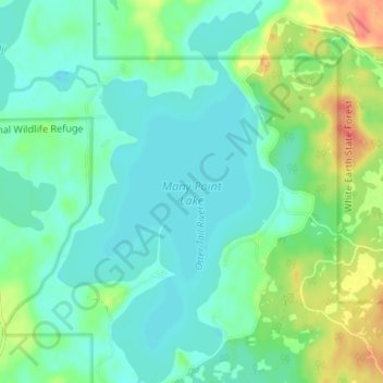
Name: Many Point Lake topographic map, elevation, terrain.

Location: Many Point Lake, Becker County, Minnesota, United States (47.05489 -95.55750 47.10023 -95.51897)

Average elevation: 1,529 ft

Minimum elevation: 1,486 ft

Maximum elevation: 1,634 ft

Minnesota trails, hiking, mountain biking, running and outdoor activities

Other topographic maps

Click on a map to view its topography, its elevation and its terrain.

Minneapolis

United States > Minnesota > Hennepin County > Minneapolis

A 1959 report by the U.S. Soil Conservation Service listed Minneapolis's elevation as 830 feet (250 m). The city's lowest elevation of 687 feet (209 m) above sea level is near where Minnehaha Creek meets the Mississippi River. Sources disagree on the exact location and elevation of the city's highest point,…

Average elevation: 889 ft

Sunrise Court

United States > Minnesota > McLeod County > Glencoe

Average elevation: 1,014 ft

Mazeppa

United States > Minnesota > Wabasha County

Average elevation: 991 ft

Rushmore

United States > Minnesota > Nobles County

Average elevation: 1,667 ft

Parkers Prairie

United States > Minnesota > Otter Tail County

Average elevation: 1,467 ft

Sanborn

United States > Minnesota > Redwood County

Average elevation: 1,073 ft

Askov

United States > Minnesota > Pine County

Average elevation: 1,161 ft

Perham

United States > Minnesota > Otter Tail County

Average elevation: 1,365 ft

Norway Lake

United States > Minnesota > Kandiyohi County

Average elevation: 1,217 ft

Wolford

United States > Minnesota > Crow Wing County

Average elevation: 1,224 ft

Becker County

United States > Minnesota

Becker County has diverse topography. It is home to several hundred lakes, many acres of fertile farm land, and forested areas. Much of the land consists of hills and deciduous trees.

Average elevation: 1,440 ft

Ranier

United States > Minnesota > Koochiching County

Average elevation: 1,122 ft

Rock County

United States > Minnesota

Rock County is located at the southwestern corner of Minnesota. Its western border shares a boundary with the eastern border of South Dakota, while its southern border is adjacent to the northern border of Iowa. The county is characterized by the flow of the Rock River, which runs southward through its east…

Average elevation: 1,539 ft

Wabasha County

United States > Minnesota

Average elevation: 1,001 ft

Sherburne County

United States > Minnesota

Average elevation: 978 ft

Mille Lacs County

United States > Minnesota

Average elevation: 1,155 ft

Dodge County

United States > Minnesota

Average elevation: 1,250 ft

Blakeley Township

United States > Minnesota > Scott County

Average elevation: 899 ft

Pine Center

United States > Minnesota > Crow Wing County

Average elevation: 1,302 ft

Houston County

United States > Minnesota

Average elevation: 971 ft

Cottonwood County

United States > Minnesota

Average elevation: 1,316 ft

Minnehaha Falls

United States > Minnesota > Hennepin County > Minneapolis

Fortunately for the generations to come, in 1883 the state legislature created the Minneapolis Board of Park Commissioners. The board began by acquiring park land near today's downtown Minneapolis. Their choice to hire noted landscape architect Horace Cleveland was fortunate. Cleveland was hired by the Board…

Average elevation: 817 ft

Waite Park

United States > Minnesota > Stearns County

Average elevation: 1,096 ft

Wilkin County

United States > Minnesota

Average elevation: 1,050 ft

Highland

United States > Minnesota > Fillmore County

Average elevation: 1,152 ft

Mora

United States > Minnesota > Kanabec County

Average elevation: 1,004 ft

West Duluth

United States > Minnesota > Saint Louis County > Duluth

Average elevation: 856 ft

Elmdale

United States > Minnesota > Morrison County

Average elevation: 1,165 ft

Murphy City

United States > Minnesota > Lake County

Average elevation: 1,867 ft

Murray County

United States > Minnesota

The county terrain consists of low rolling hills, dotted with lakes and ponds, with all available area devoted to agriculture. The terrain slopes to the south and east. However, its highest elevation occurs on Buffalo Ridge, a promontory extending about two miles along the crest of the Coteau des Prairies in…

Average elevation: 1,591 ft

Duluth Heights

United States > Minnesota > Saint Louis County > Duluth

Average elevation: 1,237 ft

Pennington County

United States > Minnesota

Average elevation: 1,109 ft

Orr

United States > Minnesota > Saint Louis County

Average elevation: 1,325 ft

New London

United States > Minnesota > Kandiyohi County

Average elevation: 1,224 ft

Kenwood

United States > Minnesota > Hennepin County > Minneapolis

Average elevation: 879 ft

Hutchinson

United States > Minnesota > McLeod County

Average elevation: 1,063 ft

Red Wing

United States > Minnesota > Goodhue County

According to the United States Census Bureau, the city has an area of 41.19 square miles (106.68 km2), of which 34.60 square miles (89.61 km2) is land and 6.59 square miles (17.07 km2) is water. The city is at the northern edge of the Driftless Area of karst topography.

Average elevation: 863 ft

Jenkins

United States > Minnesota > Crow Wing County

Average elevation: 1,266 ft

Wilmont

United States > Minnesota > Nobles County

According to the United States Census Bureau, the city has a total area of 1.14 square miles (2.95 km2), all land. By elevation, Wilmont is the highest incorporated community in Nobles County.

Average elevation: 1,729 ft

Toivola

United States > Minnesota > Saint Louis County

Average elevation: 1,286 ft

Benton County

United States > Minnesota

Average elevation: 1,115 ft

Battle Creek

United States > Minnesota > Ramsey County > Saint Paul

Average elevation: 866 ft

Tower

United States > Minnesota > Saint Louis County

Average elevation: 1,401 ft

Saint Paul

United States > Minnesota > Ramsey County > Saint Paul

The year 1858 saw more than 1,000 steamboats service Saint Paul, making it a gateway for settlers to the Minnesota frontier or Dakota Territory. Geography was a primary reason the city became a transportation hub. The location was the last good point to land riverboats coming upriver due to the river valley's…

Average elevation: 896 ft

Falcon Heights

United States > Minnesota > Ramsey County

Average elevation: 955 ft

Wayzata

United States > Minnesota > Hennepin County

Average elevation: 955 ft

Montgomery

United States > Minnesota > Le Sueur County

Average elevation: 1,060 ft

St. Charles

United States > Minnesota > Winona County

Average elevation: 1,204 ft

Hermantown

United States > Minnesota > Saint Louis County

Average elevation: 1,362 ft

Le Sueur County

United States > Minnesota

Average elevation: 1,017 ft

Dell Grove Township

United States > Minnesota > Pine County

Average elevation: 1,122 ft

Benning

United States > Minnesota > Blue Earth County > Mankato

Average elevation: 843 ft

Balaton

United States > Minnesota > Lyon County

Average elevation: 1,545 ft

La Crescent

United States > Minnesota > Houston County

Average elevation: 758 ft

Kittson County

United States > Minnesota

Kittson County was once part of glacial Lake Agassiz. Evidence of this prehistoric lake can still be seen in the county's topography. Remnants of McCauleyville Beach can be found in the eastern part of the county, an area of sandy soil and sand ridges. Other evidence of the glacier and Lake Agassiz is the…

Average elevation: 902 ft

Bucks Mill

United States > Minnesota > Becker County

Average elevation: 1,345 ft

Barrett

United States > Minnesota > Grant County

Average elevation: 1,191 ft

Big Moose Lake

United States > Minnesota > Saint Louis County

Average elevation: 1,417 ft

Kandiyohi County

United States > Minnesota

Average elevation: 1,158 ft

Hills

United States > Minnesota > Rock County

According to the United States Census Bureau, the city has a total area of 0.54 square miles (1.40 km2); 0.53 square miles (1.37 km2) is land and 0.01 square miles (0.03 km2) is water. The landscape is flat with some gently rolling hills; however, the town's name does not derive from a particular topographical…

Average elevation: 1,460 ft

Corcoran

United States > Minnesota > Hennepin County

Average elevation: 958 ft

Faribault

United States > Minnesota > Rice County

Average elevation: 1,066 ft

Shorewood

United States > Minnesota > Hennepin County

Average elevation: 961 ft

Stanchfield

United States > Minnesota > Isanti County

Average elevation: 942 ft

St. Bonifacius

United States > Minnesota > Hennepin County

Average elevation: 968 ft

Isanti

United States > Minnesota > Isanti County

Average elevation: 935 ft

Dunnell

United States > Minnesota > Martin County

Average elevation: 1,322 ft

Glendale

United States > Minnesota > Scott County > Savage

Average elevation: 860 ft

Tonka Bay

United States > Minnesota > Hennepin County

Average elevation: 938 ft

Day

United States > Minnesota > Isanti County

Average elevation: 991 ft

Grandy

United States > Minnesota > Isanti County

Average elevation: 935 ft

Elm Park

United States > Minnesota > Isanti County

Average elevation: 951 ft

Oxlip

United States > Minnesota > Isanti County

Average elevation: 945 ft

Carmody

United States > Minnesota > Isanti County

Average elevation: 981 ft

Spring Lake

United States > Minnesota > Isanti County

Average elevation: 938 ft

Bodum

United States > Minnesota > Isanti County

Average elevation: 965 ft

Money Creek

United States > Minnesota > Houston County

Average elevation: 896 ft

Andree

United States > Minnesota > Isanti County

Average elevation: 955 ft

Dalbo

United States > Minnesota > Isanti County

Average elevation: 971 ft

Pine Brook

United States > Minnesota > Isanti County

Average elevation: 955 ft

Spencer Brook

United States > Minnesota > Isanti County

Average elevation: 948 ft

Wyanett

United States > Minnesota > Isanti County

Average elevation: 961 ft

Athens

United States > Minnesota > Isanti County

Average elevation: 932 ft