
Make a donation
Gear up for your next adventure:
As an Amazon Associate, this site earns from qualifying purchases at no extra cost to you.
Kunar Province topographic map
Click on the map to display elevation.
Make a donation
Gear up for your next adventure:
As an Amazon Associate, this site earns from qualifying purchases at no extra cost to you.
About this map
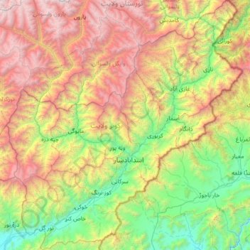
Name: Kunar Province topographic map, elevation, terrain.
Location: Kunar Province, Afghanistan (34.52566 70.57784 35.48194 71.68137)
Average elevation: 7,192 ft
Minimum elevation: 1,867 ft
Maximum elevation: 17,582 ft
Make a donation
Gear up for your next adventure:
As an Amazon Associate, this site earns from qualifying purchases at no extra cost to you.
Other topographic maps
Click on a map to view its topography, its elevation and its terrain.
Make a donation
Gear up for your next adventure:
As an Amazon Associate, this site earns from qualifying purchases at no extra cost to you.
Make a donation
Gear up for your next adventure:
As an Amazon Associate, this site earns from qualifying purchases at no extra cost to you.
Make a donation
Gear up for your next adventure:
As an Amazon Associate, this site earns from qualifying purchases at no extra cost to you.
Make a donation
Gear up for your next adventure:
As an Amazon Associate, this site earns from qualifying purchases at no extra cost to you.
Khost
Afghanistan > Khost Province > Khost
Khost has a semi-arid climate (Köppen BSk though very close to qualifying as BSh). Khost is located in the "Khost Bowl", a valley with lower elevation than the surrounding highlands, because of which it is known for its pleasant weather. With a January average of 4.8 °C (40.6 °F), Khost has noticeably…
Average elevation: 4,377 ft
Make a donation
Gear up for your next adventure:
As an Amazon Associate, this site earns from qualifying purchases at no extra cost to you.