
Fauquier County topographic map
Interactive map
Click on the map to display elevation.
Fauquier County
According to the U.S. Census Bureau, the county has an area of 651 square miles (1,690 km2), of which 647 square miles (1,680 km2) is land and 3.8 square miles (9.8 km2) (0.6%) is water. Fauquier county is not densely populated, but exurban development from Washington, DC has sprung up in some parts. Even in rural areas, housing complexes can be seen along highways. The highest point by elevation is Blue Mountain at 2,208 ft (673 meters) on the county's northwestern border with Warren County.
About this map
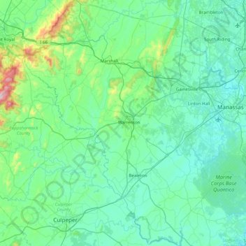
Name: Fauquier County topographic map, elevation, terrain.
Location: Fauquier County, Virginia, United States (38.40914 -78.13127 39.01377 -77.53132)
Average elevation: 499 ft
Minimum elevation: 118 ft
Maximum elevation: 3,304 ft
Virginia trails, hiking, mountain biking, running and outdoor activities
Other topographic maps
Click on a map to view its topography, its elevation and its terrain.
Virginia Beach
United States > Virginia > Virginia Beach
According to the United States Census Bureau, the city has a total area of 497 square miles (1,290 km2), of which 249 square miles (640 km2) is land and 248 square miles (640 km2) (49.9%) is water. It is the largest city in Virginia by total area and third-largest city land area. The average elevation is 12…
Average elevation: 7 ft
Eggleston
United States > Virginia > Giles County
It lies at an elevation of 1,821 feet.
Average elevation: 1,877 ft
Blue Ridge Mountains
United States > Virginia > Botetourt County
Although the term "Blue Ridge" is sometimes applied exclusively to the eastern edge or front range of the Appalachian Mountains, the geological definition of the Blue Ridge province extends westward to the Ridge and Valley area, encompassing the Great Smoky Mountains, the Great Balsams, the Roans, the Blacks,…
Average elevation: 1,509 ft
Prince William Forest Park
United States > Virginia > Prince William County > Triangle
Average elevation: 266 ft
Clinch Mountain
United States > Virginia > Washington County
For its entire length, Clinch Mountain has only one true gap through which the ridge is completely sliced in half and continues as Clinch Mountain on either side, divided by Big Moccasin Creek. It is named Moccasin Gap and runs between Weber City and Gate City, Virginia. The Norfolk Southern Railway and U.S.…
Average elevation: 2,028 ft
Blue Ridge Mountains
United States > Virginia > Bedford County
Although the term "Blue Ridge" is sometimes applied exclusively to the eastern edge or front range of the Appalachian Mountains, the geological definition of the Blue Ridge province extends westward to the Ridge and Valley area, encompassing the Great Smoky Mountains, the Great Balsams, the Roans, the Blacks,…
Average elevation: 1,798 ft
Blue Ridge Mountains
United States > Virginia > Botetourt County
Although the term "Blue Ridge" is sometimes applied exclusively to the eastern edge or front range of the Appalachian Mountains, the geological definition of the Blue Ridge province extends westward to the Ridge and Valley area, encompassing the Great Smoky Mountains, the Great Balsams, the Roans, the Blacks,…
Average elevation: 1,509 ft