
Make a donation
Gear up for your next adventure:
As an Amazon Associate, this site earns from qualifying purchases at no extra cost to you.
San Bernardino County topographic map
Click on the map to display elevation.
Make a donation
Gear up for your next adventure:
As an Amazon Associate, this site earns from qualifying purchases at no extra cost to you.
About this map
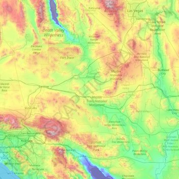
Name: San Bernardino County topographic map, elevation, terrain.
Location: San Bernardino County, California, United States (33.87105 -117.80255 35.80921 -114.13078)
Average elevation: 2,503 ft
Minimum elevation: -272 ft
Maximum elevation: 11,371 ft
California trails, hiking, mountain biking, running and outdoor activities
Make a donation
Gear up for your next adventure:
As an Amazon Associate, this site earns from qualifying purchases at no extra cost to you.
Other topographic maps
Click on a map to view its topography, its elevation and its terrain.
San Francisco Bay Area
United States > California > San Francisco
The San Francisco Bay Area is characterized by a diverse and dynamic topography shaped by geological processes over millions of years. This region features a combination of coastal plains, steep hills, and rugged mountains, all influenced by the tectonic activity associated with the nearby San Andreas Fault…
Average elevation: 371 ft
Markleeville
United States > California > Alpine County
Markleeville hosts an annual bicycle ride called the Death Ride - Tour of the California Alps. The route goes over five passes for a total distance of 129 miles and over 15,000 feet of elevation gain. In 2010 3,500 riders participated and 2,417 completed the full course of 5 mountain passes.
Average elevation: 5,866 ft
Make a donation
Gear up for your next adventure:
As an Amazon Associate, this site earns from qualifying purchases at no extra cost to you.
Mount Shasta
United States > California > Siskiyou County
Mount Shasta (Shasta: Waka-nunee-Tuki-wuki; Karuk: Úytaahkoo) is a potentially active volcano at the southern end of the Cascade Range in Siskiyou County, California. At an elevation of 14,179 feet (4,321.8 meters), it is the second-highest peak in the Cascades and the fifth-highest in the state. Mount Shasta…
Average elevation: 12,195 ft
Berkeley Hills
United States > California > Alameda County > Berkeley
The Berkeley Hills are bounded by the major Hayward Fault along their western base, and the minor Wildcat fault on their eastern side. The highest peaks are Grizzly Peak with an elevation of 1,754 feet (535 m) and Round Top, an extinct volcano with an elevation of 1,761 feet (537 m) and William Rust Summit at…
Average elevation: 518 ft
Make a donation
Gear up for your next adventure:
As an Amazon Associate, this site earns from qualifying purchases at no extra cost to you.
San Fernando Valley
United States > California > Los Angeles County > Los Angeles
Average elevation: 1,627 ft
Ramona
United States > California > San Diego County
In January 2006, Ramona Valley was designated the country's 162nd American Viticultural Area (AVA) by the Alcohol and Tobacco Tax and Trade Bureau, which recognized the area for its distinctive microclimate, elevation, and soil attributes.
Average elevation: 1,539 ft
Downieville
United States > California > Sierra County
Downieville is a census-designated place in and the county seat of Sierra County, California, United States. Downieville is on the North Fork of the Yuba River, at an elevation of 2,966 feet (904 m). The 2020 United States census reported Downieville's population was 290.
Average elevation: 3,796 ft
Make a donation
Gear up for your next adventure:
As an Amazon Associate, this site earns from qualifying purchases at no extra cost to you.
Mount Umunhum
United States > California > Santa Clara County
The mountain is also the site of the Bay Area NEXRAD weather radar. The high elevation is necessary for line of sight in the region's varied terrain, but it also limits the ability to detect storms with bases lower in the atmosphere.
Average elevation: 2,526 ft
Santa Cruz Mountains
United States > California > Santa Clara County
The Santa Cruz Mountains are a region of great biological diversity, encompassing cool, moist coastal ecosystems as well as warm, dry chaparral. Much of the area in the Santa Cruz mountains is considered temperate rainforest. In valleys and moist ocean-facing slopes some of the southernmost coast redwoods…
Average elevation: 755 ft
Make a donation
Gear up for your next adventure:
As an Amazon Associate, this site earns from qualifying purchases at no extra cost to you.
Ruben S Ayala Park
United States > California > San Bernardino County > Chino
Average elevation: 656 ft
San Diego
United States > California > San Diego County > San Diego
The climate in San Diego, like most of Southern California, often varies significantly over short geographical distances, resulting in microclimates. In San Diego, this is mostly because of the city's topography (the Bay, and the numerous hills, mountains, and canyons). Frequently, particularly during the "May…
Average elevation: 187 ft
Coachella Valley
United States > California > Riverside County > Palm Desert
The area is surrounded on the southwest by the Santa Rosa Mountains, by the San Jacinto Mountains to the west, the Little San Bernardino Mountains to the east and San Gorgonio Mountain to the north. These mountains peak at around 11,000 feet (3,400 m) and tend to average between 5,000 and 7,000 feet (1,500 and…
Average elevation: 236 ft
Make a donation
Gear up for your next adventure:
As an Amazon Associate, this site earns from qualifying purchases at no extra cost to you.
Make a donation
Gear up for your next adventure:
As an Amazon Associate, this site earns from qualifying purchases at no extra cost to you.
Oakhurst
United States > California > Madera County > Oakhurst
Oakhurst is located on the Fresno River 3 miles (5 km) south-southwest of Yosemite Forks, at an elevation of 2,274 feet (693 m). Its coordinates are 37°19′41″N 119°38′58″W / 37.32806°N 119.64944°W / 37.32806; -119.64944. It is located at the junction of state highways 41 and 49, at the…
Average elevation: 2,746 ft
Make a donation
Gear up for your next adventure:
As an Amazon Associate, this site earns from qualifying purchases at no extra cost to you.
Make a donation
Gear up for your next adventure:
As an Amazon Associate, this site earns from qualifying purchases at no extra cost to you.
Woodacre
United States > California > Marin County
The community is located at 38°00′46″N 122°38′43″W / 38.01278°N 122.64528°W / 38.01278; -122.64528 in the eastern half of the San Geronimo Valley of central Marin County. San Geronimo and Lagunitas-Forest Knolls are to its west. Woodacre is located 8 miles (13 km) south-southwest of…
Average elevation: 807 ft
Make a donation
Gear up for your next adventure:
As an Amazon Associate, this site earns from qualifying purchases at no extra cost to you.
Mammoth Mountain
United States > California > Mono County > Mammoth Lakes
Mammoth Mountain is a lava dome complex in Mono County, California. It lies in the southwestern corner of the Long Valley Caldera and consists of about 12 rhyodacite and dacite overlapping domes. These domes formed in a long series of eruptions from 110,000 to 57,000 years ago, building a volcano that reaches…
Average elevation: 9,879 ft
Make a donation
Gear up for your next adventure:
As an Amazon Associate, this site earns from qualifying purchases at no extra cost to you.
El Dorado Hills
United States > California > El Dorado County > Cameron Park
El Dorado Hills (EDH), as defined by the 2010 census-designated place (CDP), is at the western border of El Dorado County, between the City of Folsom and the unincorporated community of Cameron Park. The northern limits of the CDP are Folsom Lake and the South Fork of the American River, where river rafters…
Average elevation: 833 ft
Crowley Lake
United States > California > Mono County
Crowley Lake is a census-designated place in Mono County, California. Crowley Lake sits at an elevation of 6,939 feet (2,115 m). The 2020 United States census reported Crowley Lake's population was 980.
Average elevation: 7,385 ft
Make a donation
Gear up for your next adventure:
As an Amazon Associate, this site earns from qualifying purchases at no extra cost to you.
Rancho Peñasquitos
United States > California > San Diego County > San Diego
The highest point in the community is Black Mountain, which rises to an elevation of 1,500 feet (460 m).
Average elevation: 515 ft
Make a donation
Gear up for your next adventure:
As an Amazon Associate, this site earns from qualifying purchases at no extra cost to you.
Make a donation
Gear up for your next adventure:
As an Amazon Associate, this site earns from qualifying purchases at no extra cost to you.
Running Springs
United States > California > San Bernardino County
Running Springs is a mountain community in the San Bernardino Mountains. It is an inholding in the San Bernardino National Forest. Situated at the junction of State Route 18 and State Route 330, it is a major gateway to the mountain communities of Lake Arrowhead, Arrowbear, Green Valley Lake, and Big Bear and…
Average elevation: 5,489 ft
Upper Lake
United States > California > Lake County > Upper Lake
Upper Lake is a census-designated place (CDP) in Lake County, California, United States. Upper Lake is located 8 miles (13 km) north of Lakeport, at an elevation of 1,345 feet (410 m). The population was 1,052 at the 2010 census, up from 989 at the 2000 census. The Habematolel Pomo of Upper Lake are…
Average elevation: 1,444 ft
Make a donation
Gear up for your next adventure:
As an Amazon Associate, this site earns from qualifying purchases at no extra cost to you.
Make a donation
Gear up for your next adventure:
As an Amazon Associate, this site earns from qualifying purchases at no extra cost to you.
Swall Meadows
United States > California > Mono County
Swall Meadows sits partway up the Sherwin Grade below the Wheeler Crest of the eastern Sierra Nevada, at an elevation range of approximately 6,000 to 7,000 feet (1,800 to 2,100 m). It is in pinon-juniper/subalpine zone habitat, with views south along the Sierra Crest of Mt. Tom, and east across the Owens…
Average elevation: 6,844 ft
Make a donation
Gear up for your next adventure:
As an Amazon Associate, this site earns from qualifying purchases at no extra cost to you.
Make a donation
Gear up for your next adventure:
As an Amazon Associate, this site earns from qualifying purchases at no extra cost to you.
Laguna Hills Park
United States > California > San Luis Obispo County > San Luis Obispo
Average elevation: 269 ft
Make a donation
Gear up for your next adventure:
As an Amazon Associate, this site earns from qualifying purchases at no extra cost to you.
Make a donation
Gear up for your next adventure:
As an Amazon Associate, this site earns from qualifying purchases at no extra cost to you.
Diamond Springs
United States > California > El Dorado County
Diamond Springs (formerly, Diamond Spring and Diamond) is a census-designated place (CDP) in El Dorado County, California, United States. It is part of the Sacramento–Arden-Arcade–Roseville Metropolitan Statistical Area. The population was 11,037 at the 2010 census, up from 4,888 at the 2000 census. The…
Average elevation: 1,778 ft
Make a donation
Gear up for your next adventure:
As an Amazon Associate, this site earns from qualifying purchases at no extra cost to you.
Hilmar
United States > California > Merced County
Hilmar is an unincorporated community in Merced County, California, United States. It is located 4.25 miles (6.8 km) west-southwest of Delhi, spanning 3.9 sq mi (10 km2) and at an elevation of 92 ft (28 m) above sea level. For census purposes, Hilmar is aggregated with a nearby community into the Hilmar-Irwin…
Average elevation: 98 ft
Bodie
United States > California > Mono County
Bodie (/ˈboʊdiː/ BOH-dee) is a ghost town in the Bodie Hills east of the Sierra Nevada mountain range in Mono County, California, United States. It is about 75 miles (121 km) southeast of Lake Tahoe, and 12 mi (19 km) east-southeast of Bridgeport, at an elevation of 8,379 feet (2554 m). Bodie became a boom…
Average elevation: 8,619 ft
Make a donation
Gear up for your next adventure:
As an Amazon Associate, this site earns from qualifying purchases at no extra cost to you.
Make a donation
Gear up for your next adventure:
As an Amazon Associate, this site earns from qualifying purchases at no extra cost to you.
Make a donation
Gear up for your next adventure:
As an Amazon Associate, this site earns from qualifying purchases at no extra cost to you.
Contra Costa Centre
United States > California > Contra Costa County
Contra Costa Centre is an unincorporated community and census-designated place in Contra Costa County, California. Contra Costa Centre sits at an elevation of 92 feet (28 m). The 2010 United States census reported Contra Costa Centre's population was 5,364, while the 2020 census figure was 6,808. Contra Costa…
Average elevation: 118 ft
Make a donation
Gear up for your next adventure:
As an Amazon Associate, this site earns from qualifying purchases at no extra cost to you.
Dorrington
United States > California > Calaveras County
According to the United States Census Bureau, the CDP has a total area of 3.7 square miles (9.6 km2), 99.86% of it land. The elevation is 4,800 feet ASL.
Average elevation: 4,803 ft
Make a donation
Gear up for your next adventure:
As an Amazon Associate, this site earns from qualifying purchases at no extra cost to you.