
Bonaire topographic map
Interactive map
Click on the map to display elevation.
Bonaire
Klein Bonaire, the small island in the sheltered lee of Bonaire, has the same geological history. While Bonaire has some hills and variations in altitude, Klein Bonaire's surface is quite level and just a few feet above high tide. Because the island is as yet undeveloped, the fringing reef system surrounding Klein Bonaire is truly pristine. The smaller island is entirely ringed with dive sites.
About this map
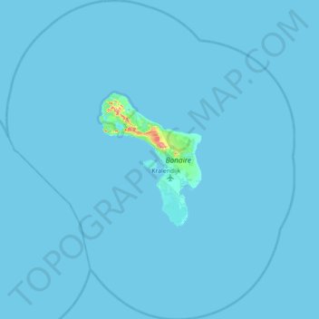
Name: Bonaire topographic map, elevation, terrain.
Location: Bonaire, Netherlands, 0000 BQ, Netherlands (11.82500 -68.62553 12.51200 -67.99163)
Average elevation: 3 ft
Minimum elevation: -3 ft
Maximum elevation: 541 ft
Other topographic maps
Click on a map to view its topography, its elevation and its terrain.